
Sharon, Queensland facts for kids
Quick facts for kids SharonBundaberg, Queensland |
|||||||||||||||
|---|---|---|---|---|---|---|---|---|---|---|---|---|---|---|---|

Sharon
Location in Queensland
|
|||||||||||||||
| Population | 1,209 (2021 census) | ||||||||||||||
| • Density | 24.77/km2 (64.2/sq mi) | ||||||||||||||
| Postcode(s) | 4670 | ||||||||||||||
| Area | 48.8 km2 (18.8 sq mi) | ||||||||||||||
| Time zone | AEST (UTC+10:00) | ||||||||||||||
| Location |
|
||||||||||||||
| LGA(s) | Bundaberg Region | ||||||||||||||
| State electorate(s) | Burnett | ||||||||||||||
| Federal Division(s) | Flynn | ||||||||||||||
|
|||||||||||||||
Sharon is a small rural area in the Bundaberg Region of Queensland, Australia. It's a place where people live, often with farms or larger properties. In 2021, about 1,209 people called Sharon home.
Contents
What is Sharon Like?
Sharon is surrounded by nature. To the north and east, you'll find Splitters Creek. The Burnett River forms its southern border.
Where is Sharon Located?
Sharon is about eight kilometres west of Bundaberg. It's on the way if you're heading towards Gin Gin.
Exploring Sharon Gorge
Just four kilometres further along the highway from Sharon is the beautiful Sharon Gorge. This area is a peaceful spot with lush rainforests. You can see many ferns, palm trees, and colourful orchids there.
The Manoo Neighbourhood
In the southwestern part of Sharon, there's a small area called Manoo. This name comes from an old railway station that used to be there. The word Manoo is an Aboriginal word. It means clear straight track.
Main Roads in Sharon
The Bundaberg-Gin Gin Road, also known as State Route 3, runs through Sharon. It helps people travel from the east to the south of the area.
A Look Back at Sharon's History
Sharon got its name from the Sharon plain in Israel. This shows a connection to places far away.
Early Churches in Sharon
In 1882, the Workman family started a Methodist Sunday School. They met on a verandah until a church could be built. The Primitive Methodist church officially opened in 1896. It was used by Primitive Methodists most Sundays. Other church groups could use it on the fourth Sunday of the month. Around 1935, this church building was sold to the Anglican Church.
The Anglican Church started holding services in the building in February 1935. St Stephen's Anglican church was officially opened on 30 April 1945. It was located near the Sharon State School. The church closed its doors in September 1991.
Schools Through the Years
Tantitha Provisional School first opened its doors on 26 February 1883. A provisional school is a temporary school. In 1894, it became a state school and was renamed Sharon State School.
Another school, Erin Hill State School, opened on 30 April 1917. It was located in the Splitters Creek area. This school closed on 14 June 1957.
Who Lives in Sharon?
The number of people living in Sharon has changed over time.
- In 2011, Sharon had 1,131 people.
- By 2016, the population grew to 1,316 people.
- In 2021, the population was 1,209 people.
Important Historical Sites
Sharon has one special place listed for its historical importance:
Learning in Sharon
Sharon State School
Sharon State School is a primary school for students from Prep to Year 6. Both boys and girls attend this government school. It is located at 18 Sharon School Road. In 2018, the school had 116 students. There were 10 teachers and 8 support staff helping them learn.
Secondary Education
There are no high schools directly in Sharon. The closest government high school is Bundaberg North State High School. It is located in Bundaberg North, to the northeast of Sharon.
Community Places
Sharon Public Hall
The Sharon Public Hall is a place where the community can gather. It is located at 1016 Gin Gin Road. People use it for events and meetings.
Images for kids
-
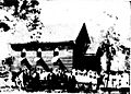
The opening of the Church of England in Sharon, around February 1935.
-
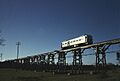
The Splitters Creek Railway Bridge.


