
Bargara, Queensland facts for kids
Quick facts for kids BargaraQueensland |
|||||||||||||||
|---|---|---|---|---|---|---|---|---|---|---|---|---|---|---|---|
 |
|||||||||||||||

Bargara
Location in Queensland
|
|||||||||||||||
| Population | 8,883 (2021 census) | ||||||||||||||
| • Density | 955/km2 (2,470/sq mi) | ||||||||||||||
| Postcode(s) | 4670 | ||||||||||||||
| Elevation | 0–10 m (0–33 ft) | ||||||||||||||
| Area | 9.3 km2 (3.6 sq mi) | ||||||||||||||
| Time zone | AEST (UTC+10:00) | ||||||||||||||
| Location |
|
||||||||||||||
| LGA(s) | Bundaberg Region | ||||||||||||||
| State electorate(s) | Burnett | ||||||||||||||
| Federal Division(s) | Hinkler | ||||||||||||||
|
|||||||||||||||
Bargara is a cool coastal town in Queensland, Australia. It's part of the Bundaberg Region. In 2021, about 8,883 people lived there.
Bargara is located about 384 kilometers (239 miles) north of Brisbane, Queensland's capital city. It's also super close to Bundaberg, just 13 kilometers (8 miles) east. You could say Bargara is like Bundaberg's beachside neighbor! Only sugar cane fields separate the two places.
Nielson Park is a small coastal area in the north of Bargara. It's only 1.5 kilometers (about 1 mile) from the main town. Most people think of Nielson Park as a great spot for picnics and beach fun in Bargara.
Contents
Exploring Bargara's Geography

Bargara's main streets are The Esplanade and Bauer Street. The Esplanade runs right along Bargara Beach. It has many modern holiday homes and apartments. Bauer Street is where you'll find hotels, restaurants, and shops. Bargara is also a popular spot for fishing, swimming, and surfing.
Just north of Bargara is the amazing Mon Repos turtle rookery. This is a special place where sea turtles come to lay their eggs. A very old wall in the park was built a long time ago using rocks from nearby sugarcane fields. Most of the coast at Mon Repos is protected. This helps keep the sea turtle nesting areas safe.
Even though Nielson Park and Bargara are officially separate, they feel like one big town. Nielson Park is mostly known as a picnic and beach area for Bargara.
Bargara has two main beaches:
- Bargara Beach is right near the town center.
- Kellys Beach is south of the town, close to the golf course.
A Look Back at Bargara's History

The area was first called Sandhills. But in 1913, it was renamed Bargara. The name Bargara comes from two nearby places: Barolin and Woongarra.
Sandhills Provisional School opened in 1893. It was renamed Bargara State School in 1921.
A church was built in South Kalkie in 1878. Around 1908, it was moved to Bargara. Another church was moved to Bargara in 1922.
From 1912 to 1948, a railway line connected Bargara to Bundaberg. This made travel easier!
The Bargara Post Office opened by 1923. Before that, there was a smaller mail office since 1912.
In 1924, the Bargara Golf Club started. They bought some swampy land to build a golf course. By 1954, they had a full 18-hole course. They even built a new clubhouse in 1997.
In 1945, people decided to build an Anglican church. St Peter's Anglican Church was officially opened in 1951.
In 2012, the Bargara Lions Club Park for the Disabled was renamed. It became the Bill Fritz Park for the Disabled. This was to honor Bill Fritz, who helped the community a lot.
Bargara has grown a lot in recent years. It's now a popular place for tourists and people who want to retire by the beach.
In 2013, a tornado hit Bargara during Australia Day. It was caused by a former tropical cyclone. The tornado damaged over 150 homes and buildings. Some people were hurt, but thankfully, everyone recovered.
Who Lives in Bargara?
In 2011, Bargara had 6,893 people. By 2016, the population grew to 7,485. About 2.7% of the people were Aboriginal and Torres Strait Islander. Most people (76.3%) were born in Australia. Others came from England (6.4%), New Zealand (3.2%), and South Africa (1.6%). Most people (90.8%) spoke only English at home.
In 2021, Bargara's population reached 8,883 people.
Places for Older People
Bargara has two big places for older people to live. They are called Palm Lake Resort and Carlyle Gardens Retirement Village.
Shopping and Businesses
The main shopping areas are on Bauer Street and See Street.
Bargara Central Shopping Centre is the biggest shopping spot. It has two supermarkets, Woolworths and Aldi. You can also find several restaurants and fast food places there.
There are also other smaller shopping centers. These include Coral Coast Plaza and Bargara Beach Plaza. Another small complex is near the Carlyle Gardens Retirement Village.
Schools Near Bargara
There are no schools right in Bargara. Bargara State School is actually in the next town over, Mon Repos. The closest high school is Kepnock State High School in Kepnock, which is part of Bundaberg.
Getting Around Bargara
Bargara has several main roads like Bargara Road, Bauer Street, and The Esplanade.
A bus route (number 4) connects Bargara to Bundaberg City and Sugarland Shopping Centre. It runs every day of the week.
Fun Things to Do and Places to Visit
There's a boat ramp at Bargara Beach. It's a great spot to launch your boat!
Churches in Bargara
Bargara has a few churches:
- St Peter's Anglican Church on Bauer Street.
- Bargara Uniting Church on Blain Street.
- St James' Catholic Church on See Street.
Sports and Clubs
The Bargara Golf Club has an 18-hole golf course. Visitors are welcome to play!
Other sports clubs include:
- Sandhills Sports Club
- Bundaberg Surf Lifesaving Club
- Bargara Football Club
Parks and Green Spaces
Bargara has many lovely parks:
- Bargara Esplanade Park, also known as Bargara Turtle Playground.
- Bargara Lakes Park
- Bargara Rotary Park
- Bauers Lookout
- Bill Fritz Park for the Disabled
- Coral Reef Park
- Crawford Park
- Davidson Street Park
- Fairway Drive Park
- Hansen-Woodhouse Park
- Ian A Cossart Park
- Jayteens Park
- Kelly's Beach Park
- Mary Kinross Park
- Moneys Creek Park
- New Bargara Park
- Nielson Park
- Nudibranch Park
- Parkside Mead Park
- Paul Petrie Park
- Settlement Court Park
- Tiny Tots Park
- Tom Riley Park
- Tom Whalley Park
- Toysons Park
- Turtle Cove Park
- Windermere Park
Images for kids
-
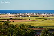
A view of Bargara from the Hummock
-
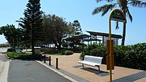
A bus stop on The Esplanade
-
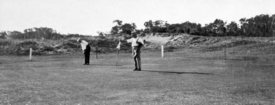
The Bargara Golf Club around 1931
-
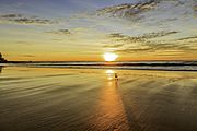
A beautiful sunrise at Kelly's Beach


