
Sidney, Montana facts for kids
Quick facts for kids
Sidney, Montana
|
|
|---|---|

Richland County courthouse
|
|
| Nickname(s):
Sunrise City
|
|

Location of Sidney, Montana
|
|
| Country | United States |
| State | Montana |
| County | Richland |
| Founded | 1888 |
| Incorporated | 1911 |
| Area | |
| • Total | 3.306 sq mi (8.563 km2) |
| • Land | 3.287 sq mi (8.514 km2) |
| • Water | 0.019 sq mi (0.049 km2) |
| Elevation | 1,949 ft (594 m) |
| Population
(2020)
|
|
| • Total | 6,346 |
| • Density | 1,859/sq mi (717.9/km2) |
| Time zone | UTC–7 (Mountain (MST)) |
| • Summer (DST) | UTC–6 (MDT) |
| ZIP Code |
59270
|
| Area code(s) | 406 |
| FIPS code | 30-67900 |
| GNIS feature ID | 2411896 |
Sidney is a city in Montana, United States. It is the main city, or county seat, of Richland County. Sidney is located less than 10 miles (16 km) west of the North Dakota border. In 2020, about 6,346 people lived there. The city is next to the Yellowstone River and close to the badlands areas of North and South Dakota. Sidney is about halfway between Glendive, Montana and Williston, North Dakota.
Contents
History of Sidney
People started moving to the Sidney area in the 1870s. A post office was set up in 1888. The town was named after six-year-old Sidney Walters. He was staying with Hiram Otis, a local judge, who thought Sidney was a good name. The next year, Montana became a state. Sidney officially became a city in 1911.
Sidney was first part of Dawson County. But in 1914, it became the main city for the new Richland County.
Farming and Growth
Farming became very important after the Lower Yellowstone Irrigation Project finished in 1909. A dam was built on the river near Glendive. This dam sent water into a long canal, about 71.6 miles (115.2 km) long. This canal runs parallel to the Yellowstone River. It helps water farms from Glendive north to Fairview. The project waters over 51,429 acres (208 km²) of land. It provides water to 450 farms.
During the Great Depression, a famous Montana artist named J. K. Ralston painted a mural in the Richland County Courthouse in Sidney. A mural is a large painting on a wall.
The town got another boost in 1924. The Holly Sugar Company opened a sugar factory in Sidney. This factory processed sugar beets grown by local farmers.
Oil Discoveries
In the late 1970s and early 1980s, the area had an oil boom. Many people moved to Sidney for a short time. Around the year 2000, there was another increase in oil exploration.
Geography and Climate
Sidney is in the northeastern part of Montana. The city covers about 3.306 square miles (8.563 km²). Most of this area is land, with a small amount of water.
Sidney is about 270 miles (435 km) northeast of Billings. It is also about 190 miles (306 km) south of Regina, Saskatchewan in Canada.
Sidney's Climate
Sidney has a semi-arid climate. This means it has long, cold, and dry winters. Summers are hot and a bit more humid.
| Climate data for Sidney, Montana, 1991–2020 normals, extremes 1910–present | |||||||||||||
|---|---|---|---|---|---|---|---|---|---|---|---|---|---|
| Month | Jan | Feb | Mar | Apr | May | Jun | Jul | Aug | Sep | Oct | Nov | Dec | Year |
| Record high °F (°C) | 61 (16) |
68 (20) |
81 (27) |
95 (35) |
102 (39) |
105 (41) |
110 (43) |
107 (42) |
101 (38) |
92 (33) |
77 (25) |
68 (20) |
110 (43) |
| Mean maximum °F (°C) | 48.1 (8.9) |
51.2 (10.7) |
68.2 (20.1) |
80.8 (27.1) |
87.8 (31.0) |
93.1 (33.9) |
97.5 (36.4) |
97.3 (36.3) |
93.5 (34.2) |
80.1 (26.7) |
61.1 (16.2) |
50.3 (10.2) |
99.6 (37.6) |
| Mean daily maximum °F (°C) | 27.2 (−2.7) |
32.0 (0.0) |
45.8 (7.7) |
60.5 (15.8) |
71.3 (21.8) |
79.1 (26.2) |
86.6 (30.3) |
86.4 (30.2) |
75.8 (24.3) |
59.4 (15.2) |
41.9 (5.5) |
30.6 (−0.8) |
58.0 (14.5) |
| Daily mean °F (°C) | 16.9 (−8.4) |
21.3 (−5.9) |
33.4 (0.8) |
46.1 (7.8) |
57.0 (13.9) |
65.7 (18.7) |
72.0 (22.2) |
70.8 (21.6) |
60.6 (15.9) |
46.5 (8.1) |
31.6 (−0.2) |
20.6 (−6.3) |
45.2 (7.3) |
| Mean daily minimum °F (°C) | 6.5 (−14.2) |
10.6 (−11.9) |
21.0 (−6.1) |
31.8 (−0.1) |
42.7 (5.9) |
52.3 (11.3) |
57.3 (14.1) |
55.1 (12.8) |
45.5 (7.5) |
33.6 (0.9) |
21.2 (−6.0) |
10.7 (−11.8) |
32.4 (0.2) |
| Mean minimum °F (°C) | −21.7 (−29.8) |
−14.2 (−25.7) |
−4.7 (−20.4) |
15.0 (−9.4) |
27.0 (−2.8) |
39.7 (4.3) |
46.9 (8.3) |
42.6 (5.9) |
30.7 (−0.7) |
15.3 (−9.3) |
0.0 (−17.8) |
−15.6 (−26.4) |
−26.3 (−32.4) |
| Record low °F (°C) | −68 (−56) |
−44 (−42) |
−29 (−34) |
−17 (−27) |
16 (−9) |
28 (−2) |
35 (2) |
30 (−1) |
15 (−9) |
−7 (−22) |
−24 (−31) |
−40 (−40) |
−68 (−56) |
| Average precipitation inches (mm) | 0.45 (11) |
0.37 (9.4) |
0.58 (15) |
1.17 (30) |
2.40 (61) |
2.78 (71) |
2.65 (67) |
1.30 (33) |
1.62 (41) |
1.08 (27) |
0.59 (15) |
0.51 (13) |
15.50 (394) |
| Average snowfall inches (cm) | 7.0 (18) |
5.6 (14) |
3.0 (7.6) |
1.7 (4.3) |
0.7 (1.8) |
0.0 (0.0) |
0.0 (0.0) |
0.0 (0.0) |
0.0 (0.0) |
1.5 (3.8) |
3.0 (7.6) |
7.9 (20) |
30.4 (77.1) |
| Average precipitation days (≥ 0.01 in) | 6.5 | 4.7 | 5.6 | 6.4 | 10.4 | 11.3 | 8.5 | 6.8 | 6.7 | 6.7 | 5.2 | 5.7 | 84.5 |
| Average snowy days (≥ 0.1 in) | 5.5 | 4.8 | 3.2 | 0.9 | 0.2 | 0.0 | 0.0 | 0.0 | 0.0 | 0.7 | 2.7 | 5.6 | 23.6 |
| Source 1: NOAA | |||||||||||||
| Source 2: National Weather Service | |||||||||||||
Economy and Jobs
Sidney's economy mainly depends on farming, ranching, and oil production. This means you'll see many farms, cattle ranches, and oil wells in the area.
For nearly 100 years, from 1925 to 2023, Sidney had a sugar beet factory. This factory was one of the biggest employers in the city. Other major employers are the Sidney Health Center and Sidney Public Schools. The sugar beet factory closed in April 2023.
Arts and Culture in Sidney
The town has a museum called the MonDak Heritage Center. It was started in 1967. The museum keeps old items and records. These show what life was like in eastern Montana and western North Dakota. You can learn about the first pioneers who arrived in the late 1800s.
Sidney also has a public library, called the Sidney-Richland County Library.
Education for Kids
Sidney has four public schools:
- Westside Elementary teaches kindergarten, 1st, and 2nd grades.
- Central Elementary teaches 3rd, 4th, and 5th grades.
- There is a Junior High School for 6th to 8th grades.
- A senior high school for 9th to 12th grades.
The sports teams at Sidney High School are called the Eagles.
There are no colleges or universities right in Sidney. However, Williston State College in North Dakota is close enough to travel to. MSU-Billings offers online courses. Sidney High School also has many classes for adults each year.
Local Media
Sidney has two local newspapers: The Sidney Herald and The Roundup.
Radio Stations
- KEYZ AM 660
- KGCX FM 93.1
- KTHC FM 95.1
- KYYZ FM 96.1
- KDSR FM 101.1
Transportation
Montana Highway 16 connects with Highway 200 in Sidney.
The town has an airport called Sidney-Richland Municipal Airport. It is about one mile (1.6 km) west of the city center. You can take flights from here through Cape Air.
Population Changes
| Historical population | |||
|---|---|---|---|
| Census | Pop. | %± | |
| 1900 | 75 | — | |
| 1910 | 345 | 360.0% | |
| 1920 | 1,400 | 305.8% | |
| 1930 | 2,010 | 43.6% | |
| 1940 | 2,978 | 48.2% | |
| 1950 | 3,987 | 33.9% | |
| 1960 | 4,564 | 14.5% | |
| 1970 | 4,543 | −0.5% | |
| 1980 | 5,726 | 26.0% | |
| 1990 | 5,216 | −8.9% | |
| 2000 | 4,774 | −8.5% | |
| 2010 | 5,191 | 8.7% | |
| 2020 | 6,346 | 22.3% | |
| 2023 (est.) | 6,112 | 17.7% | |
| source: U.S. Decennial Census 2020 Census |
|||
In 2020, Sidney had 6,346 people. There were 2,720 households, which are groups of people living together. About 82.8% of the people were White. About 6.6% of the population was Hispanic or Latino.
Notable People from Sidney
- Clyde Lamb — a cartoonist who drew funny cartoons and comic strips. He was born in Sidney.
- Roger A. Markle — a director for the U.S. Bureau of Mines. He was born in Sidney.
- Donald Nutter — a former Governor of Montana (1961–62). He grew up in Sidney.
- Barry Petersen — an Emmy Award-winning CBS News reporter. He graduated from Sidney High School in 1966.
- Chuck Stevenson — a race car driver. He was born in Sidney.
Images for kids
-
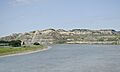
Yellowstone River near Sidney

See also
 In Spanish: Sidney (Montana) para niños
