Sierra del Carmen facts for kids
Quick facts for kids Sierra del Carmen |
|
|---|---|

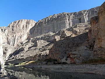
Boquillas Canyon
|
|
| Geography | |
| Country | United States, Mexico |
| State | Texas, Coahuila |
| Parent range | Sierra Madre Oriental |
The Sierra del Carmen, also known as the Sierra Maderas del Carmen, is a mountain range in Coahuila, Mexico. It's like a northern arm of the larger Sierra Madre Oriental mountain system. This range starts near the Rio Grande river, close to Big Bend National Park. It stretches southeast for about 72 kilometers (45 miles). The highest point in the Sierra del Carmen reaches about 2,719 meters (8,920 feet) high.
A part of the Sierra del Carmen is a protected area called the Maderas del Carmen Biosphere Reserve. This reserve is part of a big project between Mexico and the United States. They work together to protect a large part of the Chihuahua Desert that spans both countries.
Contents
Exploring the Sierra del Carmen's Geography
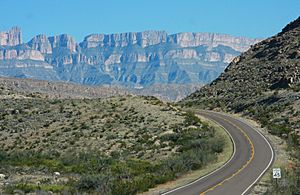
Some experts believe that the Chisos Mountains and other mountains in Big Bend National Park are part of the Sierra del Carmen. From the Mexican side of the Rio Grande, the Sierra goes southeast for about 72 kilometers (45 miles). It can be as wide as 32 kilometers (20 miles).
The mountains get taller as you go south. Several peaks are over 2,400 meters (8,000 feet) high. The highest point is 2,719 meters (8,920 feet). The western side of the Sierra del Carmen has a tall, steep cliff made of limestone. This cliff formed along a crack in the Earth's crust called a fault line.
The Sierra del Carmen is a special kind of mountain range called a "sky island." This means it's an isolated mountain that rises high above the flat Chihuahua Desert. Because it's so high, it has plants and animals that are usually found in mountains in the western United States, not typical for Mexico.
At lower parts of the mountains, you'll find desert plants. Higher up, between 1,340 and 1,800 meters (4,400 to 5,900 feet), there are forests of oak trees and oak-pine trees. Even higher, above 1,800 meters (5,900 feet), pine trees are the main type of tree. You can even find fir trees like Douglas fir and Durango fir at elevations of 2,000 meters (6,600 feet) or more.
Amazing Animals of the Sierra del Carmen
The Sierra del Carmen is home to many different kinds of animals. There are 446 types of birds and 3,600 types of insects! More than 1,500 kinds of plants grow here, and 75 different mammals live in the area.
Some of the mammals you might find include American black bears, beavers, and cougars. A special kind of white-tailed deer, called the Carmen Mountains white-tailed deer, lives only in this Sierra. Animals like pronghorn and the Mexican wolf used to live here but are not found in the Sierra anymore.
There are no major rivers, paved roads, or towns in the Sierra del Carmen. Some people call it one of the most remote places on Earth. Small streams flow down the east side of the mountains into the Rio Grande. On the western side, streams quickly disappear into the desert.
Climate of the Sierra del Carmen
The climate in the Sierra del Carmen is dry to partly dry. It gets more humid, meaning more moisture in the air, at higher elevations. The area usually gets between 25 and 50 centimeters (10 and 20 inches) of rain each year. Most of the rain falls in the summer. Snow often falls in the winter months.
The weather in the Sierra del Carmen is similar to that of Big Bend National Park. This park has a weather station that helps us understand the climate here.
| Climate data for Big Bend National Park. Elevation: 5,280 ft (1,609 m) (1942-2010) | |||||||||||||
|---|---|---|---|---|---|---|---|---|---|---|---|---|---|
| Month | Jan | Feb | Mar | Apr | May | Jun | Jul | Aug | Sep | Oct | Nov | Dec | Year |
| Record high °C (°F) | 27.8 (82.0) |
28.9 (84.0) |
35.6 (96.1) |
35.6 (96.1) |
37.2 (99.0) |
39.4 (102.9) |
38.9 (102.0) |
37.2 (99.0) |
36.1 (97.0) |
34.4 (93.9) |
31.7 (89.1) |
30.6 (87.1) |
39.4 (102.9) |
| Mean daily maximum °C (°F) | 14.7 (58.5) |
16.6 (61.9) |
20.3 (68.5) |
24.5 (76.1) |
28.2 (82.8) |
30.3 (86.5) |
29.3 (84.7) |
28.7 (83.7) |
26.3 (79.3) |
23.2 (73.8) |
18.4 (65.1) |
15.2 (59.4) |
23.0 (73.4) |
| Daily mean °C (°F) | 8.7 (47.7) |
10.3 (50.5) |
13.5 (56.3) |
17.7 (63.9) |
21.4 (70.5) |
23.8 (74.8) |
23.4 (74.1) |
22.8 (73.0) |
20.6 (69.1) |
17.1 (62.8) |
12.3 (54.1) |
9.3 (48.7) |
16.7 (62.1) |
| Mean daily minimum °C (°F) | 2.7 (36.9) |
4.0 (39.2) |
6.7 (44.1) |
10.8 (51.4) |
14.7 (58.5) |
17.3 (63.1) |
17.6 (63.7) |
17.0 (62.6) |
14.7 (58.5) |
11.0 (51.8) |
6.2 (43.2) |
3.3 (37.9) |
10.5 (50.9) |
| Record low °C (°F) | −19.4 (−2.9) |
−14.4 (6.1) |
−11.1 (12.0) |
−3.9 (25.0) |
2.8 (37.0) |
7.2 (45.0) |
11.7 (53.1) |
11.1 (52.0) |
1.1 (34.0) |
−7.2 (19.0) |
−10.6 (12.9) |
−15.6 (3.9) |
−19.4 (−2.9) |
| Average precipitation mm (inches) | 17.0 (0.67) |
15.0 (0.59) |
10.0 (0.39) |
16.0 (0.63) |
40.0 (1.57) |
57.0 (2.24) |
87.0 (3.43) |
80.0 (3.15) |
64.0 (2.52) |
39.0 (1.54) |
14.0 (0.55) |
13.0 (0.51) |
452.0 (17.80) |
| Average precipitation days (≥ 0.1 mm) | 3 | 3 | 2 | 3 | 6 | 7 | 10 | 9 | 7 | 5 | 3 | 3 | 61 |
| Source: Weatherbase: Higueras, Nuevo Leon | |||||||||||||
Working to Protect the Sierra del Carmen
The Sierra del Carmen is very isolated and mostly untouched by humans. This has led to many efforts to protect its natural environment. Both Mexico and the United States are working together on this.
Much of the Sierra del Carmen has been named the Maderas del Carmen Flora and Fauna Protected Area by the Mexican government. This special title allows some farming and private land ownership to continue. The protected area covers about 2,100 square kilometers (520,000 acres).
The Maderas del Carmen is part of a larger project called the El Carmen—Big Bend Conservation Corridor Initiative. This project connects protected lands on both sides of the border. Together, these areas cover more than 1.2 million hectares (3 million acres). This is almost as big as the U.S. state of Connecticut! In 2005, Maderas del Carmen became the first official Wilderness area in Latin America. This means it's a place where nature is left wild and undisturbed.
The Maderas del Carmen Protected Area was created in 1994. At first, conservation efforts were slow because much of the land was privately owned. It was either large ranches or collective farms called ejidos. In 2000, a Mexican company named Cementos de Mexico (CEMEX) started buying land in the region to protect it. On CEMEX's lands, they removed farm animals and fences. They encouraged native plants to grow back. By 2006, CEMEX owned about 790 square kilometers (195,000 acres) in or near Maderas del Carmen. They also managed another 253 square kilometers (62,500 acres).
One important thing about the Sierra del Carmen is that it acts like a "corridor" for animals. This means it helps wildlife move safely between north and south. In the late 1980s, this corridor helped black bears move north. They were able to come back to Big Bend National Park. Black bears had disappeared from west Texas in the 1950s.
In another project, CEMEX worked with conservation groups in Mexico and Texas. In 2000, they began raising and releasing bighorn sheep into the wild. These sheep had been gone from the Sierra del Carmen for over 50 years.
On October 24, 2011, Mexico and the United States signed an agreement. It was about working together to protect the Big Bend-Rio Bravo Natural Area. This shows how important it is to protect this special place.
See also
 In Spanish: Sierra del Carmen para niños
 | Delilah Pierce |
 | Gordon Parks |
 | Augusta Savage |
 | Charles Ethan Porter |


