Sigel, Wood County, Wisconsin facts for kids
Quick facts for kids
Town of Sigel, Wisconsin
|
|
|---|---|

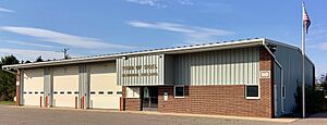
Town hall
|
|

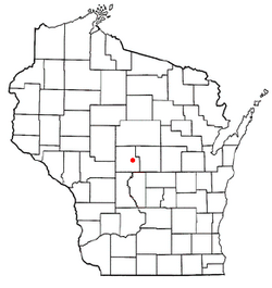
Location of the Town of Sigel, Wood County, Wisconsin
|
|
| Country | |
| State | |
| County | Wood |
| Area | |
| • Total | 35.5 sq mi (92.0 km2) |
| • Land | 35.5 sq mi (92.0 km2) |
| • Water | 0.0 sq mi (0.0 km2) |
| Elevation | 1,089 ft (332 m) |
| Population
(2000)
|
|
| • Total | 1,130 |
| • Density | 31.8/sq mi (12.3/km2) |
| Time zone | UTC-6 (Central (CST)) |
| • Summer (DST) | UTC-5 (CDT) |
| Area code(s) | 715 & 534 |
| FIPS code | 55-73900 |
| GNIS feature ID | 1584160 |
| PLSS township | T23N R5E |
The Town of Sigel is a community located in Wood County, Wisconsin, in the United States. In the year 2000, about 1,130 people lived here. The small area known as Eight Corners is also part of the town.
Contents
About Sigel's Land
The Town of Sigel covers about 35.5 square miles (92 square kilometers). Almost all of this area is land. There is only a very tiny amount of water within the town's borders.
Sigel's History
The area that is now the Town of Sigel was first measured and mapped by the U.S. government. This process is called surveying.
Early Surveys
In 1839, a team of surveyors measured the southern edge of the land. This land would later become the Town of Sigel. Then, in June 1851, another team came to measure the east and west sides.
Later that year, in November, a different team marked all the section corners. They walked through forests and swamps, using tools like a chain and a compass to measure everything.
What the Surveyors Saw
After their work, the main surveyor wrote a description of the land. He said that the northern and eastern parts of the township were good. They had fertile land with trees like Sugar Maple, Elm, Ironwood, and Birch.
The southern and western parts were not as good. They had trees like Birch, Pine, Soft Maple, and Ash. The streams in the area were fed by swamps and did not always have water. There were some scattered pine trees, but no large groups of them. The land was mostly flat and a bit rocky, with reddish stones.
Founding the Town
The Town of Sigel was officially created in 1863. It was named after Franz Sigel, who was an important officer during the American Civil War.
Who Lives in Sigel
In 2000, the census counted 1,130 people living in the Town of Sigel. There were 410 households, and 334 of these were families.
Population Details
The population density was about 31.8 people for every square mile (12.3 people per square kilometer). Most of the people living in Sigel were White (99.29%). A very small number were African American (0.09%) or Native American (0.27%). Some people (0.35%) were from two or more racial backgrounds. A small percentage (0.18%) were of Hispanic or Latino background.
Households and Families
Out of the 410 households, about 31% had children under 18 living with them. Most households (74.9%) were married couples living together. About 4.6% were single mothers with no husband present. Around 18.3% were not families.
About 14.4% of all households had only one person living there. And 5.1% had someone living alone who was 65 years old or older. On average, there were 2.76 people in each household and 3.04 people in each family.
Age and Income
The population was spread out by age:
- 24.2% were under 18 years old.
- 7.3% were between 18 and 24.
- 26.2% were between 25 and 44.
- 28.0% were between 45 and 64.
- 14.4% were 65 years old or older.
The average age of people in Sigel was 40 years. For every 100 females, there were about 107.7 males.
The average yearly income for a household in the town was $49,226. For families, the average income was $53,542. Men earned about $37,778 per year on average, while women earned about $26,429. The per capita income (income per person) for the town was $19,676.
A small number of families (1.2%) and people (2.0%) lived below the income level that is considered low-income. This included 0.8% of those under 18 and 4.1% of those 65 or older.
See also
 In Spanish: Sigel (condado de Wood, Wisconsin) para niños
 | Bayard Rustin |
 | Jeannette Carter |
 | Jeremiah A. Brown |

