
Signal Hill, St. John's facts for kids
Quick facts for kids Signal Hill |
|
|---|---|
 |
|
| Location | St. John's, Newfoundland and Labrador, Canada |
| Governing body | Parks Canada |
| Website | Signal Hill National Historic Site |
| Signal Hill | |
|---|---|
| Highest point | |
| Elevation | 167 m (548 ft) |
| Prominence | c. 167 m (548 ft) |
| Geography | |
| Location | St. John's |
| Climbing | |
| Easiest route | hillwalking |
Signal Hill is a famous hill that looks over the city and harbour of St. John's, Newfoundland and Labrador, Canada. Most of Signal Hill, including the well-known Cabot Tower, is a special place called a National Historic Site. The highest point on the hill, called Ladies' Lookout, is about 167 meters (548 feet) high.
Because of its perfect spot overlooking "The Narrows" (the only way into the harbour), people have built forts here since the mid-1600s. Something super cool happened here on December 12, 1901: the very first message sent across the Atlantic Ocean without wires (a "wireless transmission") was received by Guglielmo Marconi!
Right next to the historic site, you'll find the Johnson Geo Centre, which is a cool science museum. The small community of The Battery sits on the side of the hill, looking out at the harbour. Also, Memorial University of Newfoundland has a campus on the lower part of the hill.
Contents
Exploring Signal Hill's Past

Signal Hill has a long and exciting history! In 1762, it was the site of the very last battle of the Seven Years' War in North America. British soldiers, led by Lieutenant Colonel William Amherst, won against the French and took control of St. John's. After this victory, Amherst renamed the spot "The Lookout" to "Signal Hill." He chose this name because people used flags on its top to send messages between land and sea. This flag signalling continued for many years, all the way until 1960!
Forts and Defenses Through Time
Signal Hill was chosen as the main fort for St. John's in the late 1700s. This meant it was a very important place for protecting the city.
During the 1800s, soldiers were stationed on Signal Hill to guard against threats during big conflicts like the Napoleonic Wars and the American Civil War. A special building called the Queen's Battery Barracks was built during this time. Today, it has been carefully restored to look just like it did in 1862.
Cabot Tower: A Landmark with a Story
Work on Cabot Tower started in 1897. It was built to celebrate two important events: Queen Victoria's 60th year as queen (her Diamond Jubilee) and the 400th anniversary of John Cabot's arrival in North America in 1497. The tower officially opened in 1900. It was used for sending flag signals and also housed a Marconi wireless station, which later moved to the airport.
Marconi's Amazing Discovery

One of the most incredible moments in Signal Hill's history happened on December 12, 1901. A brilliant inventor named Guglielmo Marconi received the first-ever wireless message sent across the Atlantic Ocean! He was in an old hospital building on the hill when he heard the message, which was in Morse code. It had traveled all the way from his station in Cornwall, United Kingdom. This was a huge step forward in communication!
During World War II, American soldiers used Signal Hill to set up anti-aircraft guns to protect the area.
Signal Hill: A National Historic Site

Signal Hill is recognized as a National Historic Site. This means it's a very important place in Canadian history, protected and cared for so everyone can learn about its past.
The Signal Hill Tattoo Show

If you visit in the summer, you might get to see the exciting Signal Hill Tattoo! This show brings history to life with actors dressed as soldiers from different time periods, like the Royal Newfoundland Regiment of Foot from 1812. They perform drills and show how battles were fought long ago. You can even see cannons being fired, which adds to the excitement!
Inside Cabot Tower
Cabot Tower, located at the very top of the hill, has cool exhibits about Guglielmo Marconi and the wireless station that used to operate there. There's also a gift shop where you can find souvenirs. Sometimes, amateur radio operators use a special station inside the tower to talk to people around the world!
The Visitor Centre
The visitor centre is open during the warmer months. It has fun, interactive displays and a film that tells you all about the hill's military and communication history, as well as the story of St. John's. There's also a cafe if you need a snack!
Walking and Exploring the Trails
Signal Hill is a great place for walking and enjoying nature!
- The North Head Trail follows the edge of St. John's Harbour and the sea, offering amazing views.
- The Lady's Lookout Trail goes steeply down from Lady's Lookout, which is the highest point on Signal Hill, towards another trail called Burma Road.
- There's also a short path to the top of Gibbet Hill.
The Burma Road trail was built by American soldiers during World War II. It runs from George's Pond to Cuckold's Cove, near Quidi Vidi.
You can also explore the eight looped trails in the Johnson GEO Park. These trails have interesting outdoor displays that teach you about the local rocks, plants, and how stone was used in the past. Both the Geo Park's trails and the Signal Hill National Historic Park's trails connect to the larger Grand Concourse walkway system, so you can keep exploring!

Images for kids
-
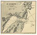
Map of St. John's in 1869, showing the harbour and old forts.
_p0703_ST_JOHN%27S.jpg)
See also
