Simard Lake (Gouin Reservoir) facts for kids
Quick facts for kids Simard Lake |
|
|---|---|

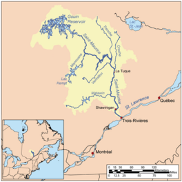
Watershed of Saint-Maurice River
|
|
| Location | La Tuque |
| Coordinates | QC_source:CGNDB_scale:250000 48°37′43″N 75°010′38″W / 48.62861°N 75.17722°W |
| Type | Lake of reservoir |
| Primary inflows | Piponisiw River |
| Primary outflows | Miller Lake (Gouin Reservoir) (a tributary of Du Mâle Lake (Gouin Reservoir) |
| Basin countries | Canada |
| Max. length | 4.2 kilometres (2.6 mi) |
| Max. width | 2.0 kilometres (1.2 mi) |
| Surface elevation | 402 metres (1,319 ft) |
Simard Lake is a freshwater lake in the province of Quebec, Canada. It is located in the northwestern part of the huge Gouin Reservoir, near the town of La Tuque.
The lake stretches across two areas called Lacasse and Crémazie. People love visiting Simard Lake for fun activities like boating and fishing. Forestry is also an important activity in the area.
Forest roads connect the lake to the village of Obedjiwan, Quebec. The lake's surface usually freezes from mid-November to the end of April. It's generally safe to walk or play on the ice from early December to the end of March. The water level can change a lot, especially in late winter, because of how water is managed at the Gouin Dam.
About Simard Lake
Simard Lake is a part of the Gouin Reservoir. Before the La Loutre Dam was built in 1916, Simard Lake was much smaller. It grew to its current size after the Gouin Dam was developed in 1946, which raised the water levels.
Where is Simard Lake?
Simard Lake is about 4.2 kilometres (2.6 mi) long and has many bays, islands, and peninsulas. It mainly gets its water from the Piponisiw River in the north.
The lake is surrounded by other important water bodies:
- To the north: Piponisiw River, Miller Lake.
- To the east: Miller Lake (Gouin Reservoir), Du Mâle Lake (Gouin Reservoir), Bourgeois Lake (Gouin Reservoir), Toussaint Lake.
- To the south: Du Mâle Lake (Gouin Reservoir), Plamondon Bay (Gouin Reservoir).
- To the west: Plamondon Creek (Gouin Reservoir), Berthelot River.
A long piece of land, like a peninsula, stretches north for 5.1 kilometres (3.2 mi) on the east side of Simard Lake. This peninsula leads to Miller Lake (Gouin Reservoir). From there, water flows through a narrow passage towards Du Mâle Lake (Gouin Reservoir). On the west side, a mountain rises 505 metres (1,657 ft) high, about 2.0 kilometres (1.2 mi) from the lake's shore.
The water level of Simard Lake is usually the same as the Gouin Reservoir. However, the level can be lowered, for example, at the end of winter, depending on how the Gouin Dam is managed.
Lake Simard's Location Details
The water from Simard Lake eventually flows into the Saint-Maurice River. The mouth of Simard Lake is located:
- 3.2 kilometres (2.0 mi) west of Miller Lake (Gouin Reservoir).
- 9.7 kilometres (6.0 mi) north of the Kaopatinak Pass.
- 17.0 kilometres (10.6 mi) southwest of Obedjiwan, Quebec, a village on the north shore of the Gouin Reservoir.
- 86.0 kilometres (53.4 mi) west of the Gouin Dam.
- 223 kilometres (139 mi) northwest of downtown La Tuque.
- 323 kilometres (201 mi) northwest of where the Saint-Maurice River meets the St. Lawrence River at Trois-Rivières.
From Simard Lake, the water travels about 101.5 kilometres (63.1 mi) to the Gouin Dam. It flows northeast through Miller Lake (Gouin Reservoir), then east through Du Mâle Lake (Gouin Reservoir), Bourgeois Lake (Gouin Reservoir), and Toussaint Lake. After that, it crosses Marmette Lake and Brochu Lake, finally reaching Kikendatch Bay and the Gouin Dam.
From the Gouin Dam, the water continues its journey down the Saint-Maurice River until it reaches Trois-Rivières. There, it joins the mighty St. Lawrence River.
What's in a Name?
The name "Simard" is a family name that comes from France. The official name "Simard Lake" was given on December 5, 1968, by the Commission de toponymie du Québec. This commission is in charge of naming places in Quebec.
 | Toni Morrison |
 | Barack Obama |
 | Martin Luther King Jr. |
 | Ralph Bunche |


