Du Mâle Lake (Gouin Reservoir) facts for kids
Quick facts for kids Du Mâle Lake |
|
|---|---|

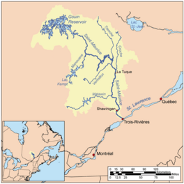
Watershed of Saint-Maurice River
|
|
| Location | La Tuque |
| Coordinates | 48°35′05″N 75°08′24″W / 48.58472°N 75.14000°W |
| Type | Lake of dam |
| Primary inflows |
|
| Primary outflows | Bourgeois Lake (Gouin Reservoir) |
| Basin countries | Canada |
| Max. length | 36.6 kilometres (22.7 mi) |
| Max. width | 14.1 kilometres (8.8 mi) |
| Surface elevation | 402 metres (1,319 ft) |
Du Mâle Lake is a large freshwater lake in Quebec, Canada. It's part of the huge Gouin Reservoir, located in the western area of the town of La Tuque. This lake is a popular spot for fun outdoor activities like boating and especially sport fishing.
The lake stretches across several different areas called cantons. These include Lacasse, Toussaint, Hanotaux, Crémazie, Lemay, Poisson, and Evanturel.
People visit Du Mâle Lake for recreation and tourism. Fishing and boating are very popular here. Forestry, which is about managing forests, is another important activity in the area.
Forest roads help people get to the lake. Road R2046 and R1045 connect to the village of Obedjiwan, Quebec in the north. Road R1009 serves the Gouin Reservoir in the west. Roads R1009 and R040 are used in the south.
The lake usually freezes over from mid-November until the end of April. However, it's safest to walk or drive on the ice from early December to late March. The water level can change a lot, especially in late winter when water is released from the Gouin Dam.
Contents
How Du Mâle Lake Was Formed
Before 1916, Du Mâle Lake was about 30 kilometres (19 mi) long. It was the main source of the Saint-Maurice River. In 1916, the La Loutre Dam was built. This created the Gouin Reservoir.
Later, in 1946, the water levels were raised again when the Gouin Dam was further developed. This made Du Mâle Lake look like it does today. It now has many bays and marshy areas. Some of these bays used to be separate lakes. These include Plamondon Bay (Gouin Reservoir), Mattawa Bay, Saraana Bay, and Aiapew Bay.
Rivers and Streams Flowing into the Lake
Many rivers and streams flow into Du Mâle Lake.
- From the north: De la Rencontre Creek, Plamondon Creek (Gouin Reservoir), Pascagama River, and Toussaint River.
- From the east: Bourgeois Lake, Thibodeau Bay, Toussaint Lake, Marmette Lake, Bureau Lake (Gouin Reservoir) (North Bay), Nemio River, and Rocher-Matci Bay.
- From the south: Bureau Lake (Gouin Reservoir) (South Bay), Hanotaux Bay, Adolphe-Poisson Bay, Mattawa Bay, Saraana Bay, Bignell Creek, Flapjack River, and Rock-Matci Bay.
- From the west: Berthelot River, Pascagama River, Plamondon Creek (Gouin Reservoir), Hanotaux Bay, Adolphe-Poisson Bay, Saveney Lake, Mégiscane River, and Mercier Lake.
Du Mâle Lake is about 36.6 kilometres (22.7 mi) long. It stretches from Mattawa Bay in the southwest to Aiapew Bay in the northeast. The lake has many islands, peninsulas, and bays. At its narrowest point, the lake is only 1.0 kilometre (0.62 mi) wide. This narrow part is called the Kaopatinak Pass.
Northeast Part of the Lake
The northeastern part of the lake is about 16.4 kilometres (10.2 mi) long and 9.4 kilometres (5.8 mi) wide. It has several smaller bays, like Miller Lake (Gouin Reservoir). The main rivers flowing into this part are the Piponisiw River and the De la Rencontre Creek.
In the northeast, there's a group of islands that separates Du Mâle Lake from Bourgeois Lake. The biggest island is 6.9 kilometres (4.3 mi) long and 2.9 kilometres (1.8 mi) wide. It's located about 6.0 kilometres (3.7 mi) west of Obedjiwan, Quebec.
Southwest Part of the Lake
The southwestern part of the lake is about 10.7 kilometres (6.6 mi) long and 12.4 kilometres (7.7 mi) wide. It extends to the Kaopatinak Pass in the middle of the lake. This part includes bays like Saraana, Mattawa Bay, Adolphe-Poisson, Hanotaux, and Plamondon.
The largest island in this area is 8.0 kilometres (5.0 mi) long. It helps form the Matci Rock Bay on the eastern side of the lake.
Where the Water Flows
The water from Du Mâle Lake flows out from its northeastern side.
- It flows about 7.6 kilometres (4.7 mi) east through Bourgeois Lake, passing south of Obedjiwan, Quebec.
- Then, it flows about 81.9 kilometres (50.9 mi) east through lakes like Marmette Lake and Brochu Lake. It then goes southeast through Kikendatch Bay towards the Gouin Dam.
From the Gouin Dam, the water continues down the Saint-Maurice River. This river eventually reaches Trois-Rivières and flows into the St. Lawrence River.
What's in a Name?
The name "Du Mâle Lake" has an interesting history.
- In 1871, a surveyor named John Bignell noted that the local Innu people called it "Ayamba Sacahigan," which means "lake to the male."
- In 1980, another survey found the Attikamek name "Aiapew Sakahikan," meaning "male moose lake."
- The Attikamek people also knew it as "Acohonan," meaning "lake where we can cross."
- Until 1945, the lake was officially called "Grand lac du Mâle" (Great Male Lake).
There's also a smaller bay in the southern part of Du Mâle Lake called "Petit lac du Mâle" (Little Male Lake). This bay has a "Sandbank" and is located between Plamondon Bay (Gouin Reservoir) and Kaopatinak Pass. This name was given in the early 1980s.
The name "Lac du Mâle" was officially recognized on December 18, 1986, by the Commission de toponymie du Québec, which is the Quebec place names commission.
 | Ernest Everett Just |
 | Mary Jackson |
 | Emmett Chappelle |
 | Marie Maynard Daly |


