Mattawa Bay facts for kids
Quick facts for kids Mattawa Bay |
|
|---|---|

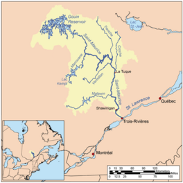
Watershed of Saint-Maurice River
|
|
| Location | La Tuque |
| Coordinates | 48°26′14″N 75°20′46″W / 48.43722°N 75.34611°W |
| Type | Lake of dam |
| Primary inflows |
|
| Primary outflows | Du Mâle Lake, Gouin Reservoir |
| Basin countries | Canada |
| Max. length | 17.0 kilometres (10.6 mi) |
| Max. width | 3.0 kilometres (1.9 mi) |
| Surface elevation | 402 metres (1,319 ft) |
Mattawa Bay is a large freshwater bay. It is located in the southwest part of the huge Gouin Reservoir. This area is part of the town of La Tuque in Quebec, Canada.
The bay stretches across the Poisson and Evanturel areas. It got its current shape after the Gouin Dam was built in 1948. The dam created the Gouin Reservoir, and Mattawa Bay became a part of it.
Most activities here are related to tourism and recreation. Fishing, boating, and enjoying nature are popular. Forestry, which is about managing forests, is also important.
Forest roads help people get around. These roads connect to Route 404. This route goes through the Mattawa Bay Valley. It also links to Route 400 in the southeast. Route 400 connects the Gouin Dam to the village of Parent, Quebec.
Mattawa Bay usually freezes over from mid-November to the end of April. However, it's generally safe to travel on the ice from early December to the end of March.
Contents
Exploring Mattawa Bay's Location
Mattawa Bay is surrounded by other bodies of water and land. Knowing its neighbors helps us understand its geography.
Nearby Waters and Land
- North side: You'll find the main Gouin Reservoir, Adolphe-Poisson Baie, Hanotaux Bay, and Plamondon Bay.
- East side: This side has Saraana Bay, Bureau Lake, Nemio River, Nemio Lake, and Lepage Lake.
- South side: Here are the Flapjack River, Bignell Creek, Clova River, and Tessier Lake.
- West side: This area includes Hanotaux Bay, Saveney Lake, Bignell Creek, and the Tamarac River.
Peninsulas and Islands
Mattawa Bay has interesting land features. A long piece of land, called a peninsula, separates it from Saraana Bay to the east. This peninsula stretches north for about 13.3 kilometers (8.3 miles). It includes a hill called "Mont de la Tête au Brochet," which means "Mount of the Pike Head." This hill is about 453 meters (1,486 feet) high.
Another peninsula separates Mattawa Bay from Adolphe-Poisson Bay to the west. This one goes north for about 11.7 kilometers (7.3 miles). There's also a large island, about 5.6 kilometers (3.5 miles) long. This island is important because it sits at the entrance of both Hanotaux Bay and Mattawa Bay. Another island, 2.2 kilometers (1.4 miles) long, is on the eastern side of Mattawa Bay's entrance.
Mattawa Bay itself is about 17.0 kilometers (10.6 miles) long. It has many islands within it. The Flapjack River flows into the bay from the south.
Where the Water Flows
The water from Mattawa Bay flows northeast into a larger bay. This larger bay is connected to Du Mâle Lake.
From the mouth of Mattawa Bay, the water travels a long way to the Gouin Dam. This journey is about 116.9 kilometers (72.6 miles).
- First, the water flows about 35.0 kilometers (21.7 miles) northeast. It crosses Du Mâle Lake and the western part of the Gouin Reservoir. This path takes it near the village of Obedjiwan, Quebec.
- Then, the water travels about 81.9 kilometers (50.9 miles) to the east. It crosses Marmette Lake, then goes southeast through Brochu Lake (Gouin Reservoir). Finally, it heads east through Kikendatch Bay until it reaches the Gouin Dam.
From the Gouin Dam, the water continues its journey down the Saint-Maurice River all the way to Trois-Rivières.
About the Name Mattawa Bay
The name "Baie Mattawa" was officially recognized on December 5, 1968. This happened when the Commission de toponymie du Québec was created. This commission is responsible for naming places in Quebec.
 | Delilah Pierce |
 | Gordon Parks |
 | Augusta Savage |
 | Charles Ethan Porter |


