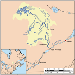
Saveney Lake facts for kids
Quick facts for kids Saveney Lake |
|
|---|---|

Watershed of Saint-Maurice River
|
|
| Location | La Tuque |
| Coordinates | 48°37′43″N 75°010′38″W / 48.62861°N 75.17722°W |
| Type | Lake of dam |
| Primary inflows | Piponisiw River |
| Primary outflows | Miller Lake (Gouin Reservoir) (a tributary of Du Mâle Lake (Gouin Reservoir) |
| Basin countries | Canada |
| Max. length | 4.2 kilometres (2.6 mi) |
| Max. width | 2.0 kilometres (1.2 mi) |
| Surface elevation | 402 metres (1,319 ft) |
Saveney Lake is a freshwater lake in Quebec, Canada. It is part of the huge Gouin Reservoir, located in the western part of the reservoir. The lake is found in the city of La Tuque, in the Mauricie region of Quebec. It stretches across two areas called Hanotaux and Poisson.
Making electricity from water, known as hydroelectric power, is the most important activity in this area. Other important activities include forestry (managing forests) and tourism, where people visit for fun.
The main road serving the western side of Saveney Lake and Adolphe-Poisson Bay is called R1009. This road also helps people get around the whole western part of the Gouin Reservoir.
Saveney Lake is usually frozen from mid-November until the end of April. However, it's generally safe to walk or drive on the ice from early December to late March.
About Saveney Lake's Location
Saveney Lake is surrounded by other important rivers and lakes. These are like its neighbors in the water system.
- To the north, you'll find the Berthelot River and Pascagama River.
- To the east, there's Adolphe-Poisson Bay, Hanotaux Bay, Saraana Bay, and Du Mâle Lake (Gouin Reservoir).
- To the south, there's Mattawa Bay, Adolphe-Poisson Bay, Bignell Creek, and Flapjack River.
- To the west, you'll see De La Tête Lake, Mégiscane River, Kekek River, and Serpent River (Mégiscane River).
Saveney Lake is about 5.2 kilometers (3.2 miles) long. It gets its water from small, unnamed lakes that flow into a bay on its western side.
The lake has several interesting bays:
- A northern bay, about 2.6 kilometers (1.6 miles) long, runs next to the northern part of Hanotaux Bay.
- Another bay stretches about 0.9 kilometers (0.6 miles) to the northeast, also towards Hanotaux Bay.
- A third bay extends about 0.9 kilometers (0.6 miles) to the south of the main part of the lake.
- A fourth bay, about 1.2 kilometers (0.7 miles) long, goes south and is where the water flows out of the lake.
The natural exit point of Saveney Lake is on its eastern side. From this point, it's:
- 5.2 kilometers (3.2 miles) southwest of the end of Hanotaux Bay.
- 18.0 kilometers (11.2 miles) southwest of the end of Kaopatinak Pass.
- 39.3 kilometers (24.4 miles) southwest of the village of Obedjiwan, Quebec, which is on the north shore of the Gouin Reservoir.
- 96.4 kilometers (59.9 miles) west of the Gouin Dam.
- 135.5 kilometers (84.2 miles) west of the village of Wemotaci, Quebec, located on the north shore of the Saint-Maurice River.
- 227 kilometers (141 miles) northwest of downtown La Tuque.
- 319 kilometers (198 miles) northwest of where the Saint-Maurice River meets the Saint Lawrence River in Trois-Rivières.
From Saveney Lake's exit, the water travels about 128.1 kilometers (79.6 miles) to the Gouin Dam. Here's how the water flows:
- First, it goes 5.3 kilometers (3.3 miles) northeast to the end of Hanotaux Bay.
- Then, it travels 40.9 kilometers (25.4 miles) northeast, crossing Du Mâle Lake (Gouin Reservoir). It then goes east, crossing Bourgeois Lake (Gouin Reservoir) and Toussaint Lake, passing south of Obedjiwan, Quebec.
- Finally, it flows 81.9 kilometers (50.9 miles) east, crossing Marmette Lake. It then turns southeast, going through Brochu Lake and Kikendatch Bay until it reaches the Gouin Dam.
From the Gouin Dam, the water continues its journey down the Saint-Maurice River. It eventually reaches Trois-Rivières, where it flows into the north side of the Saint Lawrence River.
How Saveney Lake Got Its Name
The name "lac Saveney" in French was officially recognized on December 5, 1968. This happened when the Commission de toponymie du Québec (Quebec's place name commission) was first created. This commission is in charge of naming places in Quebec.
 | DeHart Hubbard |
 | Wilma Rudolph |
 | Jesse Owens |
 | Jackie Joyner-Kersee |
 | Major Taylor |


