Hanotaux Bay facts for kids
Quick facts for kids Hanotaux Bay |
|
|---|---|

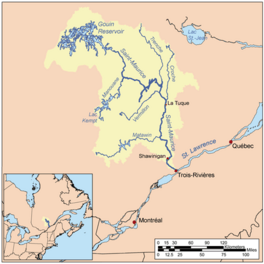
Watershed of Saint-Maurice River
|
|
| Location | La Tuque |
| Coordinates | 48°31′08″N 75°21′22″W / 48.51889°N 75.35611°W |
| Type | Bay of dam |
| Primary inflows |
|
| Primary outflows | Du Mâle Lake |
| Basin countries | Canada |
| Max. length | 8.0 kilometres (5.0 mi) |
| Max. width | 3.0 kilometres (1.9 mi) |
| Surface elevation | 402 metres (1,319 ft) |
Hanotaux Bay is a freshwater bay in Quebec, Canada. It's found in the southwest part of the large Gouin Reservoir, near the town of La Tuque. The bay mostly lies within the Hanotaux area, but also touches the Crémazie and Poisson areas.
People mostly visit this area for fun activities like fishing or boating. Logging, which is cutting down trees, is also important here.
Forest roads help people get to Hanotaux Bay. One main road, R1009, connects to other areas and even to a larger highway, Route 404.
The bay's surface is usually frozen from mid-November to the end of April. However, it's safest to walk or travel on the ice from early December to late March.
Contents
Discovering Hanotaux Bay's Geography
Hanotaux Bay is surrounded by many other lakes and rivers. These are the main water bodies nearby:
- North: Plamondon Bay, Du Mâle Lake, Plamondon Creek
- East: Gouin Reservoir, Du Mâle Lake, Bureau Lake (Gouin Reservoir)
- South: Adolphe-Poisson Bay, Mattawa Bay, Saraana Bay, Bignell Creek, Flapjack River
- West: Saveney Lake, Du Poète Lake, Berthelot River, Pascagama Lake, Mégiscane River, Mercier Lake
Hanotaux Bay is about 8.0 kilometres (5.0 mi) long. It has a unique shape, like a deformed "X," with about 50 islands in its middle.
How the Bay is Shaped
The bay's "X" shape has four main arms:
- The North-West arm stretches for about 3.9 kilometres (2.4 mi). It has a few smaller bays.
- The Northeast arm is 1.8 kilometres (1.1 mi) long. A peninsula extends south from it for about 2.5 kilometres (1.6 mi).
- The Southeast arm is shorter, about 0.7 kilometres (0.43 mi). This is where the bay's water flows out into Du Mâle Lake.
- The Southwest arm is about 3.6 kilometres (2.2 mi) long. It receives water from Adolphe-Poisson Bay.
Water Flow and Sources
Water from Adolphe-Poisson Bay flows around a large island. This island is about 5.5 kilometres (3.4 mi) long. The water goes around the south side for 5.0 kilometres (3.1 mi) and the north side for 6.1 kilometres (3.8 mi). On the north side, the water from Adolphe-Poisson Bay mixes with the water in Hanotaux Bay.
Hanotaux Bay gets most of its water from Adolphe-Poisson Bay. Adolphe-Poisson Bay itself is fed by Bignell Creek and Du Poète Lake. A special canal was built near Du Poète Lake to redirect water from the upper Mégiscane River into the Gouin Reservoir. This water then flows through Adolphe-Poisson Bay and into Hanotaux Bay.
Location and Distances
The mouth of Hanotaux Bay is located in the Southeast. Here are some distances from this point:
- 14.6 kilometres (9.1 mi) northeast of the canal from Du Poète Lake.
- 14.0 kilometres (8.7 mi) northeast of the mouth of Bignell Creek.
- 35.3 kilometres (21.9 mi) southwest of Obedjiwan, Quebec, a village on the north shore of Gouin Reservoir.
- 96.3 kilometres (59.8 mi) southwest of the Gouin Dam.
- 132.3 kilometres (82.2 mi) west of Wemotaci, Quebec, a village on the north shore of the Saint-Maurice River.
- 223 kilometres (139 mi) northwest of downtown La Tuque.
- 318 kilometres (198 mi) northwest of where the Saint-Maurice River meets the St. Lawrence River in Trois-Rivières.
From the mouth of Hanotaux Bay, the water travels about 122.8 kilometres (76.3 mi) to the Gouin Dam. It flows:
- 40.9 kilometres (25.4 mi) northeast through the western part of Gouin Reservoir, including Du Mâle Lake.
- Then, 81.9 kilometres (50.9 mi) east through Marmette Lake, then southeast through Brochu Lake, and finally east through Kikendatch Bay to the Gouin Dam.
From the Gouin Dam, the water continues its journey down the Saint-Maurice River to the city of Trois-Rivières.
The Story Behind the Name: Hanotaux Bay
The name "Hanotaux Bay" honors Gabriel Hanotaux (1853-1944). He was a famous French historian and politician. He visited Canada in 1912 for the First Congress of the French language in Quebec City. Hanotaux led a group of important French people on this trip.
Gabriel Hanotaux had a very successful career. He was an archivist and a professor. He also worked in foreign affairs and served as a diplomat in places like Constantinople. He was a member of the French Parliament in 1886 and became the Minister of Foreign Affairs from 1894 to 1898. After that, he focused on his work as a historian.
He was an expert on historical figures like Cardinal Richelieu and Egyptian history. From 1920 to 1929, he oversaw the creation of a major work called "History of the French Nation." He also helped publish a "History of the French Colonies" from 1930 to 1934, which included a lot about Canada and Quebec.
The name "Baie Hanotaux" was officially adopted by the Quebec geography commission on July 5, 1951. It was formally confirmed on June 12, 1970, by the Commission de toponymie du Québec, which is the official body for place names in Quebec.
 | DeHart Hubbard |
 | Wilma Rudolph |
 | Jesse Owens |
 | Jackie Joyner-Kersee |
 | Major Taylor |


