Plamondon Bay facts for kids
Quick facts for kids Plamondon Bay |
|
|---|---|

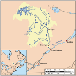
Watershed of Saint-Maurice River
|
|
| Location | La Tuque |
| Coordinates | QC_source:CGNDB_scale:250000 48°34′30″N 75°15′32″W / 48.57500°N 75.25889°W |
| Type | Baie of dam |
| Primary inflows | Plamondon Creek |
| Primary outflows | Du Mâle Lake |
| Basin countries | Canada |
| Max. length | 13.2 kilometres (8.2 mi) |
| Max. width | 5.2 kilometres (3.2 mi) |
| Surface elevation | 402 metres (1,319 ft) |
Plamondon Bay is a large freshwater bay located in Quebec, Canada. It's found in the western part of the huge Gouin Reservoir, near the town of La Tuque.
The bay stretches mainly across areas known as the Hanotaux and Crémazie townships.
Most activities around Plamondon Bay are related to tourism and recreation. Fishing, boating, and enjoying nature are popular here. Forestry, which is about managing forests for wood, is also an important activity.
Forest roads help people get to Plamondon Bay. Road R1045 comes from the village of Obedjiwan, Quebec and runs along the northwest side of the Gouin Reservoir. Road R1009 passes on the west side of Plamondon Bay.
The bay usually freezes over in mid-November. It stays frozen until the end of April. However, it's generally safe to walk or travel on the ice from early December to the end of March.
What's Around Plamondon Bay?
Plamondon Bay is surrounded by many other lakes and rivers. These are all part of the same large water system.
- To the North: You'll find Plamondon Creek, Berthelot River, and Pascagama River.
- To the East: The vast Gouin Reservoir is here, along with Du Mâle Lake and Marmette Lake.
- To the South: There are bays like Hanotaux Bay and Adolphe-Poisson Bay.
- To the West: More rivers and lakes, including Berthelot River, Pascagama River, and Mégiscane River.
How Plamondon Bay Looks
Plamondon Bay is about 13.2 kilometres (8.2 mi) long. It has a unique shape, sometimes described as looking like a "witch's arm."
- The northern part of the bay is about 3.8 kilometres (2.4 mi) long. It has several smaller bays and is where Plamondon Creek flows in.
- The southwestern part is longer, stretching for about 8.6 kilometres (5.3 mi).
- The southeastern part has many islands and peninsulas. The largest island is about 1.5 kilometres (0.93 mi) long. This area narrows into two small passages, each about 200 meters wide, before reaching the Du Mâle Lake.
The main water source for Plamondon Bay is Plamondon Creek. This creek flows into the northern end of the bay.
Location and Water Flow
The mouth, or exit, of Plamondon Bay is in the southeast. From here, the water flows into Du Mâle Lake.
Here are some distances from the mouth of Plamondon Bay:
- It's about 23.6 kilometres (14.7 mi) southwest of the village of Obedjiwan, Quebec. This village is on a peninsula in the Gouin Reservoir.
- The Gouin Dam is about 86.6 kilometres (53.8 mi) to the east.
- The city of La Tuque is about 221 kilometres (137 mi) to the southeast.
- The mouth of the Saint-Maurice River at Trois-Rivières is about 318 kilometres (198 mi) to the southeast.
From Plamondon Bay, the water travels a long way to the Gouin Dam.
- First, it flows about 28.4 kilometres (17.6 mi) northeast through Du Mâle Lake and the western part of the Gouin Reservoir.
- Then, it travels about 81.9 kilometres (50.9 mi) east through lakes like Marmette Lake and Brochu Lake, eventually reaching Kikendatch Bay and the Gouin Dam.
After passing through the Gouin Dam, the water continues its journey down the Saint-Maurice River. This river eventually joins the mighty St. Lawrence River at Trois-Rivières.
Name Origin
The name "Plamondon" comes from a French family name.
The official name "Baie Plamondon" was given on December 5, 1968. This was done by the Commission de toponymie du Québec, which is a group responsible for naming places in Quebec.
 | Kyle Baker |
 | Joseph Yoakum |
 | Laura Wheeler Waring |
 | Henry Ossawa Tanner |


