Piciw Minikanan Bay facts for kids
Quick facts for kids Piciw Minikanan Bay |
|
|---|---|

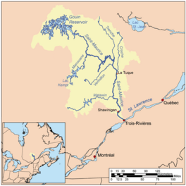
Watershed of Saint-Maurice River
|
|
| Location | La Tuque |
| Coordinates | 48°25′14″N 75°26′43″W / 48.42056°N 75.44528°W |
| Type | Lake of dam |
| Primary inflows | Outlet of unidentified lake, derivation canal coming from lake of the Poet (Mégiscane River) |
| Primary outflows | Adolphe-Poisson Bay (linked to Du Mâle Lake (Gouin Reservoir)) |
| Basin countries | Canada |
| Max. length | 2.0 kilometres (1.2 mi) |
| Max. width | 0.3 kilometres (0.19 mi) |
| Surface elevation | 402 metres (1,319 ft) |
Piciw Minikanan Bay is a freshwater bay in Quebec, Canada. It is located in the western part of the huge Gouin Reservoir. This bay is found near the town of La Tuque.
The bay is a popular spot for fun activities like boating and fishing. People also work in forestry nearby. A forest road, R1009, helps people get to the bay.
The bay usually freezes over from mid-November to late April. It's safe to walk on the ice from early December to late March. The water level in the bay can change a lot. This happens because of how water is managed at the Gouin Dam. The bay's water level always matches the level of the Gouin Reservoir.
Contents
How the Bay Was Formed
Piciw Minikanan Bay wasn't always this size. It became much bigger after the La Loutre Dam was built in 1916. This dam created the large Gouin Reservoir. The bay grew even more in 1946 when the water levels were raised again by the Gouin Dam.
Water Sources and Flow
Piciw Minikanan Bay is important because it receives water from a special channel. This channel brings water from the Lake of the Poet (Mégiscane River). It was built to move water from the Suzie River and the upper Mégiscane River into the Gouin Reservoir. The Gouin Reservoir is at the very start of the Saint-Maurice River.
The bay is about 2.0 kilometers (1.2 miles) long. It stretches towards the northeast. A peninsula on its east side helps form the Adolphe-Poisson Bay.
Nearby Waterways
Many other lakes and rivers are close to Piciw Minikanan Bay. These include:
- To the north: Rienteau Lake, Saveney Lake, Adolphe-Poisson Bay, Hanotaux Bay, Berthelot River (Mégiscane River), Plamondon Bay (Gouin Reservoir), and Pascagama River.
- To the east: Adolphe-Poisson Bay, Mattawa Bay, Du Mâle Lake (Gouin Reservoir), Saraana Bay, and Bureau Lake (Gouin Reservoir).
- To the south: Bignell Creek, Mégiscane River, Provancher Creek, and Flapjack River.
- To the west: Mégiscane River, Lake of the Poet (Mégiscane River), Brécourt Lake, and Bernier Lake.
Journey of the Water
Water from Piciw Minikanan Bay travels a long way. From the bay's mouth, the water flows about 124.7 kilometers (77.5 miles) to the Gouin Dam.
- First, it goes northeast across Adolphe-Poisson Bay for about 9.8 kilometers (6.1 miles).
- Then, it flows north through Du Mâle Lake (Gouin Reservoir). It continues east through Bourgeois Lake (Gouin Reservoir) and Toussaint Lake, passing south of Obedjiwan, Quebec. This part is about 37.3 kilometers (23.2 miles).
- Finally, it travels east across Marmette Lake, then southeast through Brochu Lake and Kikendatch Bay until it reaches the Gouin Dam. This last stretch is about 81.9 kilometers (50.9 miles).
After the Gouin Dam, the water flows down the Saint-Maurice River. It eventually reaches Trois-Rivières and joins the St. Lawrence River.
Name of the Bay
The name "Piciw Minikanan" comes from an Indigenous language.
The official French name, "Baie Piciw Minikanan," was made official on September 3, 1981. This was done by the Commission de toponymie du Québec, which is like a naming committee for places in Quebec.
 | Lonnie Johnson |
 | Granville Woods |
 | Lewis Howard Latimer |
 | James West |


