Thibodeau Bay facts for kids
Quick facts for kids Thibodeau Bay |
|
|---|---|

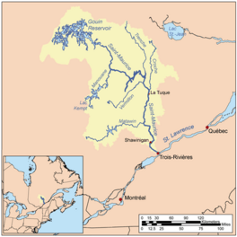
Watershed of Saint-Maurice River
|
|
| Location | La Tuque |
| Coordinates | 48°35′57″N 75°03′55″W / 48.59917°N 75.06528°W |
| Type | Lake of dam |
| Primary inflows | Du Mâle Lake (Gouin Reservoir) |
| Primary outflows | Bourgeois Lake (Gouin Reservoir) |
| Basin countries | Canada |
| Max. length | 9.7 kilometres (6.0 mi) |
| Max. width | 3.7 kilometres (2.3 mi) |
| Surface elevation | 402 metres (1,319 ft) |
Thibodeau Bay is a freshwater bay found in the middle of the Gouin Reservoir in Quebec, Canada. It's part of the town of La Tuque. This bay stretches across two areas called Toussaint and Lemay.
People love visiting Thibodeau Bay for fun activities. Fishing and boating are very popular here. The area also has some logging, which means cutting down trees for wood.
You can reach Thibodeau Bay using forest roads. These roads connect to the village of Obedjiwan, Quebec.
The bay usually freezes over from mid-November until the end of April. It's generally safe to walk or travel on the ice from early December to late March. The water level can change a lot, especially in late winter, because of how water is managed at the Gouin Dam.
Contents
Where is Thibodeau Bay?
Thibodeau Bay is a part of the large Gouin Reservoir. It is located in the northern-central section of this big body of water.
How Thibodeau Bay was Formed
Before 1916, Thibodeau Bay was much smaller. That's when the La Loutre Dam was built, which started to create the Gouin Reservoir. The bay got its current shape after the water level was raised again in 1946. This happened when the Gouin Dam was further developed.
Nearby Waters
Many other lakes and bays are close to Thibodeau Bay.
- To the north: Bourgeois Lake (Gouin Reservoir), De la Rencontre Creek, Aiapew Bay, Du Mâle Lake (Gouin Reservoir), Kanatakompeak Bay.
- To the east: Bourgeois Lake (Gouin Reservoir), Toussaint Lake, Marmette Lake, McSweeney Lake, Magnan Lake.
- To the south: Bureau Lake (Gouin Reservoir) (North Bay), Rocher-Matci Bay.
- To the west: Du Mâle Lake (Gouin Reservoir), Plamondon Creek (Gouin Reservoir), Berthelot River, Pascagama River.
Size and Shape
Thibodeau Bay is about 16.3 kilometres (10.1 mi) long from north to south. It has a narrow part in the north, which is about 1.6 kilometres (0.99 mi) long. On the south side, it connects to a bay in Du Mâle Lake (Gouin Reservoir).
There are many islands near Thibodeau Bay. One large island, about 7.2 kilometres (4.5 mi) long and 3.1 kilometres (1.9 mi) wide, separates Thibodeau Bay from Du Mâle Lake (Gouin Reservoir). This island is about 6.0 kilometres (3.7 mi) west of Obedjiwan, Quebec.
On the east side, a long piece of land stretches north for 4.1 kilometres (2.5 mi). An island, 2.9 kilometres (1.8 mi) long, continues from this land. Water from Thibodeau Bay flows into Bourgeois Lake (Gouin Reservoir) through two narrow passages around this island.
Where the Water Flows
The water from Thibodeau Bay eventually reaches the Gouin Dam.
- It flows 9.5 kilometres (5.9 mi) north through Bourgeois Lake (Gouin Reservoir).
- Then it goes east through Toussaint Lake, passing south of Obedjiwan, Quebec.
- After that, it travels 81.9 kilometres (50.9 mi) east through lakes like Marmette Lake and Brochu Lake.
- Finally, it reaches Kikendatch Bay and then the Gouin Dam.
From the Gouin Dam, the water flows down the Saint-Maurice River. This river eventually joins the St. Lawrence River at Trois-Rivières.
Name Origin
The name "Thibodeau" is a French family name. The official name "Baie Thibodeau" was given on December 18, 1986, by the Commission de toponymie du Québec.
 | Aurelia Browder |
 | Nannie Helen Burroughs |
 | Michelle Alexander |


