
Simla, Colorado facts for kids
Quick facts for kids
Simla, Colorado
|
|
|---|---|

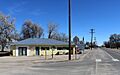
Looking east along Highway 24 in Simla.
|
|

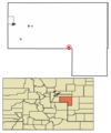
Location of Simla in Elbert County, Colorado.
|
|
| Country | |
| State | |
| County | Elbert County |
| Incorporated | January 15, 1912 |
| Government | |
| • Type | Statutory Town |
| Area | |
| • Total | 0.62 sq mi (1.60 km2) |
| • Land | 0.62 sq mi (1.60 km2) |
| • Water | 0.00 sq mi (0.00 km2) |
| Elevation | 5,978 ft (1,822 m) |
| Population
(2020)
|
|
| • Total | 601 |
| • Density | 972.9/sq mi (375.63/km2) |
| Time zone | UTC-7 (MST) |
| • Summer (DST) | UTC-6 (MDT) |
| ZIP code |
80835
|
| Area code(s) | 719 |
| FIPS code | 08-70635 |
| GNIS feature ID | 0193219 |
Simla is a small town in Elbert County, Colorado, United States. It is about 48 miles northeast of Colorado Springs. In 2020, the town had a population of 601 people.
Contents
History of Simla
Simla was started in 1909 by a man named Altman. The town got its name from a book about India that a railroad official's daughter was reading. She found the name Simla in the book. People began settling in the area in the 1880s. Simla officially became a town in 1912. The first local newspaper began in 1911. Simla was an important place for shipping potatoes grown in the area.
Simla also received national attention. It was the first place in the United States where a new type of the COVID-19 virus was found.
Geography and Location
Simla is located in the southern part of Elbert County. It is found at coordinates 39.140746 degrees North and 104.082836 degrees West. The town is south of Big Sandy Creek. This creek flows east and eventually joins the Arkansas River.
U.S. Route 24 goes right through Simla. This highway leads southwest to Colorado Springs. It also goes northeast about 24 miles to Limon. The United States Census Bureau says that Simla covers a total area of 1.4 square kilometers (0.54 square miles). All of this area is land.
People of Simla
The population of Simla has changed over the years. Here is a quick look at how many people have lived there:
| Historical population | |||
|---|---|---|---|
| Census | Pop. | %± | |
| 1920 | 387 | — | |
| 1930 | 351 | −9.3% | |
| 1940 | 421 | 19.9% | |
| 1950 | 424 | 0.7% | |
| 1960 | 450 | 6.1% | |
| 1970 | 460 | 2.2% | |
| 1980 | 494 | 7.4% | |
| 1990 | 481 | −2.6% | |
| 2000 | 663 | 37.8% | |
| 2010 | 618 | −6.8% | |
| 2020 | 601 | −2.8% | |
| U.S. Decennial Census | |||
In 2000, there were 663 people living in Simla. These people lived in 233 households. About 171 of these households were families. The town had about 1,222 people per square mile.
Most people in Simla in 2000 were White (94.27%). A small number were African American (0.45%), Native American (1.96%), or Asian (0.30%). Some people were from other races or from two or more races. About 3.62% of the population was Hispanic or Latino.
Many households (40.3%) had children under 18 living with them. More than half (56.7%) were married couples. About 13.3% of households had a female head with no husband. The average household had 2.73 people. The average family had 3.24 people.
The town's population was spread out by age. About 32.4% were under 18 years old. About 15.4% were 65 years or older. The average age in Simla was 34 years.
Big Sandy High School Sports
Big Sandy High School in Simla is well-known for its successful sports teams. The school's teams are called the Simla Cubs. They have won many state championships.
The Simla Cubs have won 11 team state championships:
- 5 in football
- 2 in boys' basketball
- 2 in girls' basketball
- 2 in girls' volleyball
- 1 in boys' track and field
Many individual athletes from Simla have also won state championships.
Famous Athletes from Simla
Simla has been home to some famous athletes.
- Glenn Morris won a gold medal in the 1936 Olympic decathlon.
- Barry Helton was a professional football player in the NFL.
Images for kids
-
Looking east along Highway 24 in Simla.
-
Location of Simla in Elbert County, Colorado.
See also
 In Spanish: Simla (Colorado) para niños
