Slade Point, Queensland facts for kids
Quick facts for kids Slade PointMackay, Queensland |
|||||||||||||||
|---|---|---|---|---|---|---|---|---|---|---|---|---|---|---|---|

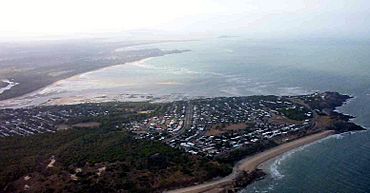
Aerial view of Slade Point, 2005
|
|||||||||||||||
| Population | 3,450 (2021 census) | ||||||||||||||
| • Density | 479/km2 (1,240/sq mi) | ||||||||||||||
| Postcode(s) | 4740 | ||||||||||||||
| Area | 7.2 km2 (2.8 sq mi) | ||||||||||||||
| Time zone | AEST (UTC+10:00) | ||||||||||||||
| Location |
|
||||||||||||||
| LGA(s) | Mackay Region | ||||||||||||||
| State electorate(s) | Mackay | ||||||||||||||
| Federal Division(s) | Dawson | ||||||||||||||
|
|||||||||||||||
Slade Point is a lovely coastal town and suburb located on a peninsula in the Mackay Region of Queensland, Australia. It's a place where the land meets the beautiful Coral Sea. In 2021, about 3,450 people called Slade Point home.
Contents
Exploring Slade Point's Geography
Slade Point is a coastal area, meaning it's right next to the ocean. The clear waters of the Coral Sea form its northern and most of its eastern borders.
This area has some cool coastal spots:
- Slade Bay (21°04′08″S 149°12′40″E / 21.0689°S 149.2112°E) is a beautiful bay.
- Slade Point (21°03′50″S 149°13′30″E / 21.0639°S 149.2250°E) is the main headland, a piece of land sticking out into the sea.
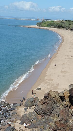
- Lamberts Beach (21°04′31″S 149°13′42″E / 21.0753°S 149.2282°E) is a popular beach.
A Look at Slade Point's History
Slade Point has an interesting past. It was first called Amhurst. On January 1, 1967, its name was changed to Slade Point.
How Slade Point Got Its Name
The name "Slade Point" comes from the headland itself. This headland was named in June 1770 by Lieutenant James Cook. He was on the ship HMS Endeavour and named it after Thomas Slade. Thomas Slade was a Surveyor of the Royal Navy and helped design famous ships, like Horatio Nelson's ship HMS Victory.
Schools and Community Buildings
Amhurst State School first opened its doors on April 11, 1939. When the town's name changed, the school also changed its name to Slade Point State School in 1967.
Around 1975, a Catholic church opened on Finch Street. It has since become a home, but you can still see the cross on the building.
Home of a Champion
Slade Point is also famous as the birthplace of Cathy Freeman. She is a well-known Australian Olympic athlete. There's even a recreation area where she used to race as a child that is now named after her!
Who Lives in Slade Point?
The number of people living in Slade Point has grown over the years.
- In 2016, about 3,349 people lived in Slade Point.
- By 2021, the population had grown to 3,450 people.
Learning in Slade Point
Slade Point has a great primary school for younger students.
Slade Point State School
Slade Point State School is a government primary school. It teaches students from Prep (the first year of school) to Year 6. You can find it at 362 Slade Point Road (21°04′26″S 149°12′53″E / 21.0739°S 149.2147°E). In 2018, the school had 204 students.
Secondary Education Options
There isn't a high school right in Slade Point. Older students usually go to Pioneer State High School. This school is in the nearby suburb of Andergrove, which is to the south-west.
Places to Visit and Things to Do
Slade Point has several places where people can shop, relax, and gather.
Shopping and Services
- Slade Point Central shopping centre (21°04′45″S 149°12′52″E / 21.0793°S 149.2145°E) is a good place to find what you need. It used to be called Seagull Shopping Centre.
- The Slade Point Post Office (21°04′45″S 149°12′54″E / 21.0793°S 149.2150°E) is located inside this shopping centre.
- The Mackay Regional Council also runs a mobile library service. It visits Pheasant Street every two weeks, bringing books and resources to the community.
Community and Recreation
- Slade Point Community Hall (21°04′33″S 149°13′08″E / 21.0759°S 149.2189°E) is a place where community events and meetings are held.
- If you enjoy lawn bowls, you can visit the Mackay RSL Memorial Bowls Club (21°04′23″S 149°13′08″E / 21.0731°S 149.2190°E). It's also known as Slade Point Bowls Club.
- Life Giving Church (21°04′35″S 149°13′04″E / 21.0764°S 149.2177°E) is a local church that used to be called Slade Point Christian Life Centre.
Top Attractions in Slade Point
Slade Point offers some beautiful sights and unique art.
Coastal Views and Whale Watching
- Lamberts Beach Lookout (21°04′16″S 149°13′44″E / 21.0711°S 149.2288°E) is a fantastic spot. From here, you can enjoy amazing views of the coast. During the right season, you might even see whales swimming by!
The Water Tower Mural
- The Slade Point water tower (21°04′01″S 149°13′32″E / 21.0669°S 149.2256°E) has been turned into a giant work of art! Artists Scott Nagy and Cara Sanders painted a beautiful mural on it. The mural shows the whale migration and features the local red-tailed black cockatoos that you can often see along the esplanade.
 | Emma Amos |
 | Edward Mitchell Bannister |
 | Larry D. Alexander |
 | Ernie Barnes |


