Slate Islands facts for kids
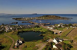
The Slate Islands are a group of islands in Scotland. They are part of the Inner Hebrides, located just off Scotland's west coast. You can find them north of Jura and southwest of Oban.
The main islands in this group are Seil, Easdale, Luing, Shuna, Torsa and Belnahua. Nearby islands like Scarba and Kerrera are usually not included.
These islands are named "Slate Islands" because of the slate rock found beneath them. People dug up this slate for building materials until the mid-1900s. Quarrying started way back in 1630. Around 1900, the quarries produced about eight million slates every year!
Contents
What Are the Slate Islands?
The Slate Islands don't have a super strict definition. But generally, they are the islands where a lot of slate was dug up for business. These include Easdale, Belnahua, Luing, and Seil.
The Slate Islands Heritage Trust also focuses on these four islands. Other sources might include a few more. For example, Shuna and Torsa are often added to the list. Torsa is a tidal island, meaning you can walk to it from Luing when the tide is low.
So, the Slate Islands usually mean Easdale, Belnahua, Luing, Seil, and their close neighbours Shuna and Torsa. This also includes the smaller, empty islands nearby.
Island Geography
Here are the main islands in the group:
| Island | Gaelic name | Area (ha) | Population (2011) | Population (2001) | Highest point | Height (m) |
|---|---|---|---|---|---|---|
| Belnahua | Beul na h-Uamha | c.6 | 0 | 0 | 22 | |
| Easdale | Eilean Èisdeal. | 25 | 59 | 58 | – | 38 |
| Luing | Luinn | 1,430 | 195 | 212 | Binnein Furachail | 87 |
| Seil | Saoil | 1,329 | 551 | 560 | Meall Chaise | 146 |
| Shuna | Siùna | 451 | 3 | 1 | Druim na Dubh Ghlaic | 90 |
| Torsa | Torsa | 113 | 0 | 0 | – | 62 |
Torsa had people living on it until the 1960s. Belnahua had many people when slate quarrying was busy. But in 1914, the quarry closed, and no one has lived there since.
Many smaller islands and rocks are scattered around the main islands. Most are not well known. Only Fladda, which has an old lighthouse keeper's house, and maybe Insh might have had people living on them.
- Belnahua: Fladda, Ormsa
- Easdale: None
- Luing: Diar Sgeir, Dubh-fheith, Dubh Sgeir, Eilean Loisgte, Fraoch Eilean (2), Funaich Mhòr, Glas Eilean, Rubh Aird Luing, Sgeir Bhuidhe
- Torsa: Eilean Fraoch, Glas Eilean, Torsa Beag
- Seil: Dubh-sgeir, Eilean à Chomraidh, Eilean Bàn-leac, Eilean Buidhe, Eilean Dùin, Eilean nam Beathach, Eilean nam Freumha, Eilean Tornal, Henderson's Rock, Insh, Sgeir Beul na h-Uamhaidh
- Shuna: None
Eilean-a-beithich was once one of the Slate Islands. It was located in Easdale Sound. But people dug so much slate from it that the island became a huge hole. This hole went down about 75 meters (246 feet) below sea level. In 1881, the sea broke through the edge of the island. This flooded the quarry, and now very little of the island can be seen.
Island Names
The name Belnahua comes from the Scottish Gaelic words Beul na h-Uamha. This means "the mouth of the cave." Torsa is also a Gaelic name, but it comes from Old Norse. It means "Thorir's island."
The names of the other main islands are not as clear. Seil and Luing probably have very old names, even older than Gaelic. Their meanings are unknown. Shuna is Siùna in Gaelic and might mean "sea island" in Norse. Easdale seems to mix Gaelic and Norse words. Eas is Gaelic for "waterfall," and dal is Norse for "valley." But it's strange because this small island is flat and has no waterfalls. The name might have come from the nearby village of Ellenabeich on Seil.
Island Geology
The most important rock on these islands is called Easdale Slate. It's a type of rock that was formed a very long time ago. This slate was used for building.
Before the Ice Ages, the Slate Islands were part of a long piece of land. This land stretched from mainland Scotland through Scarba and Jura to Islay. But then, a huge glacier cut through it. This created the islands we see today. The whole area was covered by ice. The glacier carved deep channels into the seabed, making the waters in the Firth of Lorn very deep, over 210 meters (689 feet) in some places.
Island History
From about the 500s to the 700s AD, a group called the Cenél Loairn controlled the area. This area is now known as Lorn, which includes the Slate Islands. They were part of the kingdom of Dalriada.
Later, in the late 700s, the area became a battleground. Celtic rulers from mainland Argyll fought against new settlers from Norway, called the Norsemen. The Norse language influenced many place names here. This shows that the islands became part of the Kingdom of the Isles, which was ruled by Norse kings.
The Clan MacDougall was a powerful family in the area. They were loyal to the King of Norway for their island lands. But in 1266, the Treaty of Perth was signed. This treaty gave the Hebrides and other islands to the Kingdom of Scotland.
During the Wars of Scottish Independence, the MacDougalls fought against King Robert the Bruce. They lost, and King Robert took most of their lands, including the islands. However, their lands were later given back to them.
Centuries later, the MacDougalls lost land again. This time, it was to the Duke of Argyll. The Slate Islands then became part of the lands owned by the Breadalbane family. In the 1600s, the Dukes of Argyll started renting out land differently. This led to many people being forced to leave their homes. This happened long before the famous Highland Clearances. In the 1900s, the Breadalbane family sold off their land on the islands.
Slate Quarrying
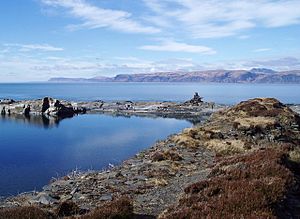
People started digging for slate on Easdale as early as the 1100s. In 1745, a company was formed to make slate quarrying a bigger business. At first, Easdale produced 1 million slates each year. By 1800, production grew to 5 million slates per year.
More slate quarries opened on Eilean-a-beithich, Belnahua, Luing, and Seil. Small railways were built to move the slate from the quarries to the harbors. Production reached its highest point in the 1860s, with 9 million slates made each year. These slates were sent to places like England, Canada, the Caribbean, the USA, Norway, and New Zealand.
But in 1881, a big storm hit. A very strong wind and high tide flooded the quarries on Easdale and Eilean-a-beithich. A large rock wall supporting a sea wall broke. Eilean-a-beithich never reopened. While other quarries continued, demand for slate changed. Clay tiles became popular for roofs instead. By 1911 on Seil and 1914 on Belnahua, commercial slate production stopped. Balvicar quarry reopened for a short time in the mid-1900s, but today, no slate is mined on the Slate Islands.
Economy and Transport
Today, the islands mostly rely on farming, tourism, and lobster fishing. The Ellenabeich Heritage Centre opened in 2000. It's run by the Slate Islands Heritage Trust. The center is in an old slate worker's cottage. It shows what life was like in the 1800s, how slate was quarried, and information about local plants, animals, and rocks.
Seil island has been connected to the Scottish mainland since 1792. This is thanks to the Clachan Bridge, also called the "Bridge Over the Atlantic." Ferries leave Seil from Ellenabeich to Easdale. Another ferry goes from Cuan to Luing across the Cuan Sound. The Easdale ferry uses a special chain and cog wheel system.
The seas around the Slate Islands have seen many shipwrecks. One sad event was the sinking of the Helēna Faulbaums in 1936. She was caught in a storm and hit a reef near Belnahua. The ship sank quickly, and 15 people lost their lives. Four sailors were rescued the next day.
The waters around all the Slate Islands are part of a special protected area called the Loch Sunart to the Sound of Jura Marine Protected Area.
See also
 In Spanish: Islas Slate (Escocia) para niños
 | Jewel Prestage |
 | Ella Baker |
 | Fannie Lou Hamer |


