
Scarba facts for kids
Scarba (Scottish Gaelic: Sgarba) is a small island in Argyll and Bute, Scotland. It is located just north of the much larger island of Jura. No one has lived on Scarba permanently since the 1960s. Today, the island is covered in purple heather and is a home for grazing animals. Kilmory Lodge is a building used sometimes for hunting, as Scarba has many red deer.
The island's name comes from the Norse language. It might mean "sharp, stony, hilly land" or "cormorant island."
| Gaelic name | Sgarba |
|---|---|
| Norse name | Skarpoe |
| Meaning of name | Old Norse for "sharp, stony, hilly terrain" |
 Cruach Scarba |
|
| OS grid reference | NM690044 |
| Coordinates | 56°10′37″N 5°43′12″W / 56.177°N 5.72°W |
| Physical geography | |
| Island group | Islay |
| Area | 1,474 ha (5.69 sq mi) |
| Area rank | 39 |
| Highest elevation | Cruach Scarba 449 m (1,473 ft) |
| Administration | |
| Sovereign state | United Kingdom |
| Country | Scotland |
| Council area | Argyll and Bute |
| Demographics | |
| Population | Not permanently inhabited since the 1960s |
| Largest settlement | Kilmory Lodge |
Getting to Scarba
Scarba does not have regular public ferries. However, you can arrange a boat trip from Craobh Haven or Crinan Harbour with local boat owners.
Exploring the Island
| Cruach Scarba | |
|---|---|
| (Scottish Gaelic: 'Cruach Sgarba') | |
| Highest point | |
| Elevation | 449 m (1,473 ft) |
| Prominence | 449 m (1,473 ft) |
| Listing | Marilyn |
| Naming | |
| English translation | Hill of Scarba |
| Language of name | Gaelic |
| Geography | |
| Location | Inner Hebrides, Scotland |
| OS grid | NM690044 |
| Topo map | OS Landranger 55 |
The island has a rough ridge at its top. You can reach it from the harbour at the north end. From there, a vehicle track goes up past Kilmory Lodge to about 200 metres high. After that, there are no clear paths, and the ground becomes rough and wet.
The island rises steeply to its highest point, called Cruach Scarba, which is 449 metres (1,473 feet) tall. A special marker called a triangulation point shows the highest summit. Several small lochs (lakes) are found around the summits.
What is the Corryvreckan?

Between Scarba and Jura is the Gulf of Corryvreckan. This area is famous for its powerful whirlpool. In 1549, a writer named Dean Monro described "Skarbay" and the waters between it and "Duray" (Jura): "There runs a stream, stronger than any sailing or rowing can handle, with endless dangers, called Corybrekan. This stream is eight miles long, which can only be used at certain tides. This Skarbay is four miles long from west to east, and one mile wide, a high, rough island, lived on and farmed, with some woods on it."
Scarba and some nearby small islands, like Lunga and the Garvellachs, are part of a special area. This area is called the Scarba, Lunga and the Garvellachs National Scenic Area. It is one of 40 such areas in Scotland. These areas are chosen because they have amazing scenery, and they are protected to make sure they stay beautiful.
Images for kids
-
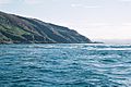
The Corryvreckan whirlpool
-
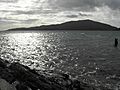
The view from Luing looking towards Scarba
-
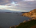
Na h-Urrachann, Isle of Scarba, looking north towards the Slate Islands
-
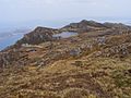
A view northwards along the summit ridge from a short distance north of the highest point


See also
 In Spanish: Scarba para niños
