
Lunga, Firth of Lorn facts for kids
| Gaelic name | Lunga |
|---|---|
| Norse name | Langr-oy |
| Meaning of name | Old Norse for 'isle of the longships' |
| OS grid reference | NM706086 |
| Coordinates | 56°13′N 5°42′W / 56.22°N 5.70°W |
| Physical geography | |
| Island group | Slate Islands |
| Area | 250 ha (0.97 sq mi) |
| Area rank | 96= |
| Highest elevation | Bidean na h-Iolaire 98 m (322 ft) |
| Administration | |
| Sovereign state | United Kingdom |
| Country | Scotland |
| Council area | Argyll and Bute |
| Demographics | |
| Population | 0 |
| Largest settlement | Rubha Fiola Centre |
Lunga is a small island in Scotland. It is part of the Slate Islands group. You can find it in the Firth of Lorn in Argyll and Bute.
The name 'Lunga' comes from an old language called Old Norse. It means 'isle of the longships'. Most other places on the island have Gaelic names.
Lunga has never had many people living on it. Today, its main activity is an adventure centre. This centre is located on the northern tip of the island, called Rubha Fiola. The waters around Lunga are important for fishing. People catch prawns and scallops here. There is also a salmon farm nearby.
Lunga is part of a special protected area. This area is great for outdoor activities. You can go scuba diving or canoeing here.
Contents
Exploring Lunga's Geography
Lunga is about 2 kilometers (1.2 miles) west of Luing island. It is just north of Scarba. The closest big town is Oban, which is about 16 kilometers (10 miles) north.
The Grey Dog Tidal Race
To the south of Lunga, there is a narrow channel. It is called Bealach a' Choin Ghlais, which means 'pass of the grey dog'. This channel is only about 200 meters (220 yards) wide. It is famous for a very strong tidal current called the 'Grey Dog'. This current can move as fast as 8 knots (about 15 kilometers per hour).
In 1845, someone described it like this: "The water rushes through this narrow pass with great force. Even during normal tides, you cannot push a boat through it."
This strong current is sometimes called the 'Little Corryvreckan'. The real Gulf of Corryvreckan is a much bigger whirlpool. It is located between Scarba and Jura, just a few miles south.
Islands and Waters Around Lunga
Many small islands surround Lunga. To the north is Belnahua. To the northwest are Eilean Dubh Mor and the Garvellachs. If you look straight west, the next land you see is the Dubh Artach lighthouse. After that, it's just the open Atlantic Ocean.
When the tide is high, the northern part of Lunga splits into several smaller islands. These include Rubha Fiola, Fiola Meadhonach, Eilean Ioasal, and Fiola an Droma. There are also many tiny rocks and islets all around. This mix of land and sea, along with the strong tides, makes these waters very tricky to navigate.
The highest point on Lunga is Bidean na h-Iolaire, which means 'peak of the eagle'. The main bay is Camas a Mhor-Fhir (bay of the giant) to the south. This bay offers a safe place to escape the strong Grey Dog current. Another safe spot for boats is Poll nan Corran on the east coast. It has a beach made of pebbles.
Lunga's History and Legends
The legend of the 'Grey Dog' channel is connected to the story of the Gulf of Corryvreckan. The legend says that a Norse prince named Breacan drowned in the Corryvreckan whirlpool. His dog then swam to land to find him. The dog searched on Jura and Scarba. Then, it tried to jump across the channel to Lunga. But it missed its step on Eilean a' Bhealaich, a small island in the middle of the channel. The dog fell into the strong current and drowned. That's why the channel is called the 'pass of the grey dog'.
An old book from 1549 mentioned Lunga. It said the island was "three miles long" and "good for animals and crops." It also noted that Lunga had a "sufficient harbor for Highland galleys."
Like many remote Scottish islands, Lunga's population decreased over time. In 1794, 29 people lived there. By 1931, only 5 people remained. Lunga was not lived on permanently during the 1960s and 1970s.
Amazing Wildlife of Lunga
The waters around Lunga are full of life. Besides prawns and scallops, you can find rare sea creatures. One example is the seafan anemone Amphianthus dohrnii. Large kelp forests, like Laminaria hyperborea, grow in many areas. In deeper, calmer waters, you might see feather stars and tiny animals called hydroids.
On land, Lunga is home to European otters and red deer. In the sea, you can often spot Atlantic grey seals, minke whales, bottlenose dolphins, and harbour porpoises. Look up, and you might see Golden eagles or white-tailed sea eagles flying overhead.
Lunga is part of the Scarba, Lunga and the Garvellachs National Scenic Area. This is one of 40 such areas in Scotland. These areas are protected because they have amazing scenery. Lunga is also part of the Firth of Lorn marine Special Area of Conservation. This helps protect the unique marine life here.
The Lunga Island Group
Lunga is the largest island in a group of islands. This group lies between the Isles of the Sea and the Sound of Luing. Besides Lunga, some of the other islands and islets in this group are:
- Eilean Dubh Mòr
- Eilean Dubh Beag
- Ormsa
- Belnahua
- Fladda
- Eilean nan Ceann
- Sgeir Poll nan Corran
- Sgeir Mhic an Altair
- Eilean a' Bhealaich
- Guirasdeal
- An Tudan
- Liath Sgeir
These islands are often considered part of the larger Slate Islands group.
Images for kids
-
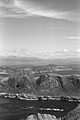
Lunga from Scarba with the Grey Dog in the foreground, looking north to Mull
-
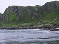
Lunga's raised beaches
-
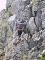
On the 'Kiwi' climb at Rubha Fiola
-
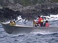
A bumpy ride around Lunga


