
Firth of Lorn facts for kids
Quick facts for kids Firth of Lorne |
|
|---|---|

Firth of Lorne
Location in Scotland
|
|
| Location | Scotland, United Kingdom |
| Coordinates | 56°20′N 5°45′W / 56.333°N 5.750°W |

The Firth of Lorn (also spelled Lorne) is a beautiful stretch of water on the west coast of Scotland. In Scottish English, a "firth" is like a long arm of the sea, similar to a fjord. The name "Lorn" comes from an old region in Scotland called Lorn or Lorne.
This area is very important for nature. In 2005, a large part of the eastern side of the firth became a Special Area of Conservation (SAC). This means it's a protected place because of its special habitats, like reefs and rocky islands. The Firth of Lorn also includes parts of two of Scotland's 40 official national scenic areas. These are places known for their amazing natural beauty.
Contents
Exploring the Firth of Lorn


For a long time, the exact borders of the Firth of Lorn were a bit unclear on maps. However, in recent years, scientists have studied the area more closely. Organizations like Scottish Natural Heritage (SNH) have helped define the firth's boundaries. SNH is a government body that works to protect Scotland's natural places.
These studies have helped us understand the firth better. They divide it into two main parts:
- The Inner Firth of Lorn is the water directly south of the Isle of Mull and around the islands on the east side.
- The Outer Firth of Lorn stretches further south from Mull, reaching towards the Isle of Jura.
The inner part of the firth connects to several other waterways. These include Loch Linnhe, Loch Etive, and the Sound of Mull. There are also smaller inlets like Loch Spelve and Loch Don on Mull, and Loch Feochan on the mainland. The firth is about 17 miles (27 km) long and can be from 5 to 15 miles (8 to 24 km) wide. It has a deep channel on its west side that leads to the Caledonian Canal.
A Look at History
Even though the Firth of Lorn is a well-known name today, it wasn't always used to describe this specific body of water. People have sailed and lived around this area for centuries. For example, in 1535, a pilot named Alexandre Lindsay helped James V of Scotland explore the Scottish coast. His sailing directions mention Lismore, Scotland, an island that helps shelter ships in the Firth of Lorn.
Historically, the area was important for ships seeking shelter from bad weather. The Caledonian Canal, built much later, also connected to these waters, making it easier for boats to travel through Scotland.
The Earth Beneath the Water
The long, narrow shape of the Firth of Lorn is actually part of a much larger geological feature. It lies along the Great Glen Fault. This is a huge crack in the Earth's crust that runs through Scotland, including the famous Great Glen and Loch Linnhe, and even extends into Ireland.
Weather and Water
The tides in the Firth of Lorn are very powerful. They create some interesting natural events:
- The Falls of Lora happen at the entrance to Loch Etive. Here, the tide rushing out creates a series of rapids and waterfalls.
- The Gulf of Corryvreckan is a narrow strait between the islands of Scarba and Jura. Strong tides here can create huge whirlpools and standing waves, which are powerful and famous.
Images for kids
-
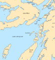
Firth of Lorn
-
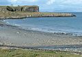
Rock platform and raised cliff at Port Donain, Isle of Mull
-
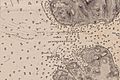
The Great Race, where the flood tide emerges from between Jura (S) and Scarba (N) into the main part of the Firth of Lorn
-
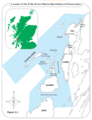
Firth of Lorn Special Area of Conservation Map


See also
 In Spanish: Fiordo de Lorn para niños
