
Seil facts for kids
| Gaelic name | Saoil |
|---|---|
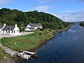
 Cottages at Ellenabeich under the cliffs of Dùn Mòr |
|
| OS grid reference | NM742172 |
| Coordinates | 56°18′N 5°37′W / 56.30°N 5.62°W |
| Physical geography | |
| Island group | Slate Islands |
| Area | 1,329 ha (5.13 sq mi) |
| Area rank | 42 |
| Highest elevation | Meall Chaise, 146 m (479 ft) |
| Administration | |
| Sovereign state | United Kingdom |
| Country | Scotland |
| Council area | Argyll and Bute |
| Demographics | |
| Population | 551 |
| Population density | 41.4/km2 (107/sq mi) |
| Largest settlement | Balvicar |
Seil (called Saoil in Scottish Gaelic) is a beautiful island in Scotland. It's part of the Slate Islands group. You can find it on the east side of the Firth of Lorn, about 7 miles (11 km) southwest of Oban. What's cool about Seil is that it has been connected to the Scottish mainland by a bridge since the late 1700s!
The name of the island, Seil, has a bit of a mystery around it. It probably comes from a very old language, even before Gaelic. In the 7th century, Seil was part of a kingdom called Dál Riata. By the 1500s, people on Seil mostly worked in farming. Later, the Breadalbane family owned the island. In the early 1700s, they started to use the island's rich slate deposits. For the next two centuries, slate from Seil's quarries was sent all over the world! Today, the island's economy mainly relies on farming and tourism.
The waters around Seil, especially the Firth of Lorn, can be tricky. Many ships have been lost there over the years. The local Kilbrandon Church has amazing stained glass windows and a connection to Saint Brendan.
Contents
What's in a Name?

The names of many Scottish islands are very old. Sometimes, we don't know exactly what they mean. This suggests they were named a very long time ago, maybe by the first people who settled here after the Ice Age.
One old document from around AD 700, called the Ravenna Cosmography, lists some Scottish island names. The island of Saponis mentioned in this list might be Seil.
Seil's name is likely pre-Gaelic, but some people think it might come from Norse (Viking) words. There's also a theory that Seil could be Hinba, an island linked to Saint Columba. This idea comes from Seil's connection to Saint Brendan. Also, it was on an old trade route from Antrim to the north. The narrow waters at Clachan Bridge might be the "great sea bag" mentioned in old texts about Hinba.
An old map from 1654, the Blaeu Atlas of Scotland, shows the modern spelling of "Seil."
Island Geography

Seil is very close to mainland Scotland. It's separated by the Clachan Sound, which is only about 70 feet (21.3 meters) wide at its narrowest point. To the west of Seil is the Firth of Lorn. South of Seil, across the Cuan Sound, is the island of Luing. Further away are Lunga and Scarba.
Seil is surrounded by other smaller islands. These include its fellow Slate Islands: Easdale, Torsa, Belnahua, and Shuna. Eilean Dubh Mòr is to the southwest, and Insh is to the northwest.
The highest point on Seil is a hill called Meall Chaise. It stands about 479 feet (146 meters) above sea level.
Seil is about 7 miles (11 km) from Oban by road.
Balvicar is the main village in the middle of the island. It has a harbor for fishing boats, the island's shop, and a golf club. On the west side of Seil is Ellenabeich. This village used to be a slate-mining town. It's famous for its white cottages where slate workers lived. Many artists and people on holiday enjoy staying here, especially in the summer.
There are also three other small villages: Cuan at the southern tip, Oban Seil north of Balvicar, and Clachan Seil, which is closest to the Clachan Bridge.
Island History

In the 7th century, a group called the Cenél Loairn controlled the area now known as Lorn. Seil was part of their lands in the kingdom of Dál Riata.
Ardfad Castle is a ruined castle in the northwest of Seil. It was once home to the Macdougalls of Ardencaple. However, after King James VII lost his fight to regain the thrones in the late 1600s, the Macdougalls lost much of their land to the Duke of Argyll. By 1971, only parts of one tower of the castle remained.
Seil then became part of the lands owned by the Breadalbane family. They were a branch of Clan Campbell. In the 20th century, their land was sold off as smaller farms and houses. Many famous members of Clan Campbell are buried at Kilbrandon churchyard on Seil. In the late 1600s, the Dukes of Argyll started renting out land based on who paid the most. This led to many people being forced to leave Seil and the surrounding area in 1669. This happened even before the bigger Highland Clearances.
Slate Mining on Seil
People started using slate from Easdale, near Seil, as early as the 1100s. In 1730, Colin Campbell of Carwhin was put in charge of using the area's natural resources. In 1745, he started the Easdale Marble and Slate Company. This made slate mining a much bigger business.
At first, Easdale produced 1 million slates a year. Just two years later, production jumped to 2.5 million! By 1800, with more quarries opening, the company was making 5 million slates a year.
The small island of Eilean-a-beithich, between Seil and Easdale, was quarried down to a depth of 260 feet (80 meters). Other slate quarries opened on Luing and at Balvicar. Small railway lines were built to carry the rock from the quarries to the harbors.
Slate production reached its highest point in the 1860s, with 9 million slates made each year! These slates were sent to places like England, Nova Scotia, the West Indies, the US, Norway, and New Zealand.
But then, disaster struck in 1881. On November 22, a huge storm and very high tide flooded the quarries on Easdale and at Eilean-a-beithich. A large rock support for a sea wall broke under the water's pressure. Eilean-a-beithich never reopened. While some slate production continued at Easdale, Luing, and Balvicar, the demand for slate changed. Clay tiles became more popular for roofs. Commercial slate production stopped by 1911. Balvicar quarry reopened for a short time from the late 1940s to the early 1960s, but today, slate is no longer mined anywhere in the Slate Islands.
Life on Seil Today

Today, the island's economy mostly depends on farming, tourism, and lobster fishing. The Ellenabeich Heritage Centre opened in 2000. It's run by the Slate Islands Heritage Trust. The center is in an old slate quarry worker's cottage. It shows what life was like in the 1800s, how slate was quarried, and information about the local plants, animals, and geology.
Seil has been connected to the Scottish mainland since 1792 or 1793. That's when the Clachan Bridge was built by engineer Robert Mylne. This bridge is also known as the "Bridge Over the Atlantic." It has a 70-foot (21.3-meter) span. Its arch is 40 feet (12.2 meters) above the seabed, allowing small boats to pass underneath.
Ferries sail from Ellenabeich to Easdale. Another ferry goes from Cuan to Luing across the Cuan Sound. This water is only 650 feet (200 meters) wide, but the tides can rush through it very fast, up to 9 miles per hour (14.4 km/h)!
Religion and History

Seil has a link to Brendan of Clonfert, a saint from the sixth century. He set up a monastery on the Garvellachs and later a small church where Kilbrandon Church now stands. The modern church, located between Balvicar and Cuan, has five beautiful stained glass windows by Douglas Strachan. They show scenes from the Sea of Galilee. The middle window shows a ship in a storm. The bright colors show the storm's power, the crew's fear, and Christ's calm. It's a very dramatic piece of art.
Fun Facts and Media

There's a famous pub called Tigh na Truish (which means "house of the trousers" in Gaelic) at Clachan Seil. The story goes that after the Jacobite Rebellion in 1745, Highland dress (like kilts) was banned. Islanders supposedly swapped their kilts for trousers here before going to the mainland.
Parts of the movie Ring of Bright Water were filmed on Seil.
Shipwrecks Near Seil
The Firth of Lorn is a busy sea route for ships traveling to and from Oban and Fort William. Because of this, there are several shipwrecks around Seil.
The wooden sailing ship Norval got stuck in fog near Insh on September 20, 1870. You could still see parts of it in 1995. On August 15, 1900, the iron steamship Apollo ran aground on Bono Reef, 1.5 miles (2.4 km) southwest of Seil. It was carrying granite stones from Aberdeen to Newport. The wreck lies about 33 feet (10 meters) deep. In February 1933, the Hafton was on its way from Toboronochy on Luing to Mull. It started leaking and sank about 9 miles (14 km) into its trip. The five crew members got into a small boat and safely reached Ellanabeich.
Island Wildlife

In early summer, the Clachan Bridge is covered in beautiful fairy foxgloves (Erinus alpinus) flowers. The narrow waters under the bridge have trapped large sea animals before. In 1835, a whale with a 21-foot (6.4-meter) lower jaw got stuck there. In 1837, an amazing 192 pilot whales were trapped, the largest being 26 feet (8 meters) long!
Gallery
-
Clachan Sound from Clachan Bridge, looking north
-
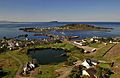
The flooded quarry and village of Ellenabeich with the outline of the former island of Eilean-a-beithich at center left and Easdale beyond
-
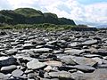
Slate on the shoreline of Seil
-
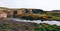
Flooded slate quarry near Balvicar
-
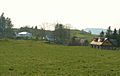
The scattered settlement of Oban Seil
-
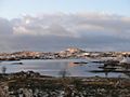
Balvicar Bay in winter, seen from mainland Scotland, looking towards the heights of Bàrr Mòr


Images for kids
-
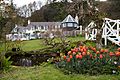
An Cala house and gardens
.jpg)
See also
 In Spanish: Seil para niños
