
Kerrera facts for kids
| Norse name | Kjarbarey |
|---|---|
| Meaning of name | Norse for 'Kjarbar's island' or possibly 'copse island' |
 Gylen Castle |
|
| OS grid reference | NM813281 |
| Coordinates | 56°23′53″N 05°32′19″W / 56.39806°N 5.53861°W |
| Physical geography | |
| Island group | Mull |
| Area | 1,214 ha (4.69 sq mi) |
| Area rank | 44 |
| Highest elevation | Carn Breugach 189 m (620 ft) |
| Administration | |
| Sovereign state | United Kingdom |
| Country | Scotland |
| Council area | Argyll and Bute |
| Demographics | |
| Population | 34 |
| Population density | 2.8/km2 (7.3/sq mi) |
| Largest settlement | Bailiemore |
Kerrera (also called Cearara in Scottish Gaelic) is a small island in the Inner Hebrides of Scotland. It is very close to the town of Oban. In 2016, about 45 people lived there, split into two groups in the north and south parts of the island.
Contents
What is Kerrera Made Of?
The oldest rocks on Kerrera are black slate. On top of this, you can find sandstone and lava rocks. These rocks formed a very long time ago, when the area was dry land. You can even see old ripple marks and sun cracks in some rocks, which shows they were once soft mud that dried out. There are also thin layers of limestone on the island.
All these rocks are cut by igneous dykes. These are like walls of rock that formed when hot, melted rock pushed up through cracks. Many geological faults (cracks in the Earth's crust) also cross Kerrera. More recently, you can find modern beach sand and old raised beaches around the island.
Where is Kerrera?
Kerrera is about 7 kilometers (4.3 miles) long and 2 kilometers (1.2 miles) wide. It is separated from the mainland by the Sound of Kerrera, which is about 500 meters (0.3 miles) wide. The highest point on the island is Carn Breugach, which is 189 meters (620 feet) tall.
You can get to Kerrera by two different ferry services. A passenger ferry, the MV Carvoria, runs from Gallanach Road, which is about 3 kilometers (1.9 miles) southwest of Oban. From where the ferry lands, you can follow tracks to the small villages in the middle and south of the island. There is a walking path around the south end of the island that takes about 3 hours to complete.
The northern part of the island can be reached by a separate ferry that goes to Oban Marina. This marina is linked by a track to the rest of the island.
A Look Back at Kerrera's History
Kerrera is famous for the ruined Gylen Castle. This small tower house was built in 1582. It is also the place where Alexander II of Scotland died in 1249.
The famous artist J. M. W. Turner visited Kerrera in 1831. He drew 25 sketches of Gylen Castle, which are now kept in the Tate Gallery in London.
Life on Kerrera Today
Most of Kerrera island is owned by the McDougalls of Dunollie family. They are related to Somerled, a powerful Norse-Gael leader from a long time ago. A small tidal island called Rubh a' Chruidh, which is about 4 acres (1.6 hectares) big, was sold in 2010.
In 2011, the island had 34 people living there. However, by 2019, residents said the population had grown to 68 people, including 18 children!
There are no public buildings or shops on the island, except for two compost toilets provided by the community. In July 2019, the Isle of Kerrera Development Trust, a local community group, bought the old primary school building. It had been empty since 1997. The community plans to fix it up and turn it into a useful center for everyone.
The main jobs on the island are farming, especially raising sheep and Highland cattle, and tourism. There used to be a special bird sanctuary, but it closed in 2017. There is a tea room and café called Kerrera Tea Garden & Bunkhouse near Gylen Castle. As of 2016, there were no paved roads, no shop, and no pub on the island. Gylen Castle itself was partly fixed up in 2006 and is open for visitors to explore.
Gallery
-

Outline map of Kerrera.
-
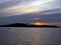
Sunset over Kerrera, viewed from Oban.
-
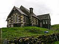
Disused school on Kerrera


Images for kids
-
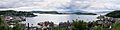
View of Kerrera from McCaig's tower in Oban
-
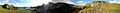
Landscape of the south of Kerrera showing Gylen Castle
See also
 In Spanish: Kerrera para niños
