
Smithsonian Butte facts for kids
Quick facts for kids Smithsonian Butte |
|
|---|---|

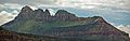
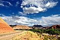
Smithsonian Butte, north aspect
|
|
| Highest point | |
| Elevation | 6,780 ft (2,070 m) |
| Prominence | 1,400 ft (430 m) |
| Isolation | 3.21 mi (5.17 km) |
| Parent peak | Canaan Mountain (7,363 ft) |
| Geography | |

Smithsonian Butte
Location in Utah

Smithsonian Butte
Location in the United States
|
|
| Location | Canaan Mountain Wilderness Washington County, Utah, US |
| Parent range | Colorado Plateau |
| Topo map | USGS Smithsonian Butte |
| Geology | |
| Age of rock | Jurassic |
| Type of rock | Navajo sandstone |
| Climbing | |
| Easiest route | class 5.3 climbing |
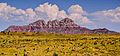
Smithsonian Butte is a tall mountain peak in southwest Utah, United States. It stands about 6,780-foot (2,070 m) high. You can find it in the beautiful Canaan Mountain Wilderness area of Washington County. This amazing natural landmark is part of the Colorado Plateau region.
Contents
About Smithsonian Butte
Smithsonian Butte is located about four miles southwest of Rockville. It is also four miles south of the famous Zion National Park. You can easily see this impressive mountain from Utah State Route 9.
How Tall is It?
This mountain rises very steeply from the ground around it. On its south side, it climbs 2,000 feet (600 meters) in just one mile. On its north side, it rises an incredible 3,000 feet in three miles above the Virgin River. The Virgin River helps drain water from the mountain when it rains or snows.
What is the Mountain Made Of?
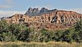
The very top of Smithsonian Butte is made of light-colored rock. This rock is called Navajo Sandstone, which formed during the Jurassic period. Below this, you can see deep-red sandstone from the Kayenta Formation. These different rock layers make the mountain look very colorful and unique.
How Did It Get Its Name?
A geologist named Clarence Edward Dutton (1841–1912) gave the mountain its name. He named it after the Smithsonian Institute. The Smithsonian Institute had helped fund his trips to explore this region. The name was officially recognized in 1934.
From 1875 to 1877, Dutton and his team mapped a huge area of southern Utah. They explored about 12,000 square miles (31,000 km2) of high plateaus. There is even a place called Dutton Pass, which is a low area between Smithsonian Butte and Canaan Mountain, named after him. You can reach this mountain by driving along the Smithsonian Butte National Back Country Byway.
Climate and Weather
The best times to visit Smithsonian Butte are during spring and fall. The weather is usually very pleasant then.
Weather Patterns
Smithsonian Butte is in a Cold semi-arid climate zone. This means that the coldest month of the year has an average temperature below 32 °F (0 °C). Also, at least half of the yearly rain and snow falls during spring and summer. This desert area gets less than 10 inches (250 millimeters) of rain each year. Snowfall in winter is usually light.
Images for kids
-
-
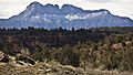
South aspect
-
-
-
-
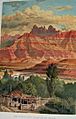
Smithsonian Butte shown in a colored picture by William Henry Holmes. This picture was in a book from 1882 by Clarence E. Dutton.


