Smyth County, Virginia facts for kids
Quick facts for kids
Smyth County
|
|||
|---|---|---|---|

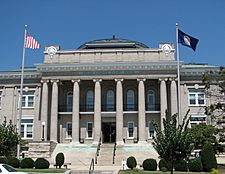
Smyth County Courthouse in Marion
|
|||
|
|||

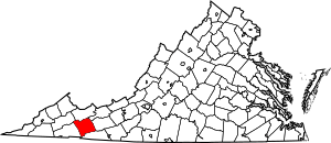
Location within the U.S. state of Virginia
|
|||
 Virginia's location within the U.S. |
|||
| Country | |||
| State | |||
| Founded | 1832 | ||
| Named for | Alexander Smyth | ||
| Seat | Marion | ||
| Largest town | Marion | ||
| Area | |||
| • Total | 452 sq mi (1,170 km2) | ||
| • Land | 451 sq mi (1,170 km2) | ||
| • Water | 1.4 sq mi (4 km2) 0.3% | ||
| Population
(2020)
|
|||
| • Total | 29,800 | ||
| • Density | 65.93/sq mi (25.46/km2) | ||
| Time zone | UTC−5 (Eastern) | ||
| • Summer (DST) | UTC−4 (EDT) | ||
| Congressional district | 9th | ||
Smyth County is a county located in the state of Virginia in the United States. In 2020, about 29,800 people lived there. The main town and county seat is Marion.
Contents
History of Smyth County
Smyth County was created on February 23, 1832. It was formed from parts of Washington and Wythe counties.
The county is named after Alexander Smyth. He was a general during the War of 1812. He also served in the Virginia state government and as a Representative in the U.S. Congress.
Geography of Smyth County
According to the U.S. Census Bureau, Smyth County covers a total area of 452 square miles (about 1,171 square kilometers). Most of this area, 451 square miles (1,168 square kilometers), is land. Only a small part, 1.4 square miles (3.6 square kilometers), is water.
Smyth County is part of the Appalachian Regional Commission. This group works to improve the economy and life in the Appalachian region.
Neighboring Counties
Smyth County shares borders with these other counties:
- Russell County – to the northwest
- Tazewell County – to the north
- Bland County – to the northeast
- Wythe County – to the east
- Grayson County – to the south
- Washington County – to the southwest
Protected Natural Areas
Parts of these national protected areas are found in Smyth County:
- Jefferson National Forest
- Mount Rogers National Recreation Area
Main Roads
These are some of the major highways that go through Smyth County:
 I-81
I-81 US 11
US 11 SR 16
SR 16 SR 42
SR 42 SR 91
SR 91 SR 107
Population of Smyth County
The population of Smyth County has changed over the years. Here's a look at how many people have lived there during different census counts:
| Historical population | |||
|---|---|---|---|
| Census | Pop. | %± | |
| 1840 | 6,522 | — | |
| 1850 | 8,162 | 25.1% | |
| 1860 | 8,952 | 9.7% | |
| 1870 | 8,898 | −0.6% | |
| 1880 | 12,160 | 36.7% | |
| 1890 | 13,360 | 9.9% | |
| 1900 | 17,121 | 28.2% | |
| 1910 | 20,326 | 18.7% | |
| 1920 | 22,125 | 8.9% | |
| 1930 | 25,125 | 13.6% | |
| 1940 | 28,861 | 14.9% | |
| 1950 | 30,187 | 4.6% | |
| 1960 | 31,066 | 2.9% | |
| 1970 | 31,349 | 0.9% | |
| 1980 | 33,366 | 6.4% | |
| 1990 | 32,370 | −3.0% | |
| 2000 | 33,081 | 2.2% | |
| 2010 | 32,208 | −2.6% | |
| 2020 | 29,800 | −7.5% | |
| U.S. Decennial Census 1790–1960 1900–1990 1990–2000 2010 2020 |
|||
In 2020, the population of Smyth County was 29,800 people. Most of the people living in the county were White. There were also smaller groups of Black or African American, Asian, and Native American people. About 1.87% of the population was Hispanic or Latino.
Tourism in Smyth County
The Smyth County Tourism Association was started in 2006. Its goal is to help tourism grow in a way that is good for the area. They manage the H.L. Bonham Regional Development and Tourism Center. They also promote the area through their website, visitsmythcountyva.com.
Education in Smyth County
Smyth County has several schools and educational programs.
Public High Schools
- Chilhowie High School, in Chilhowie
- Marion Senior High School, in Marion
- Northwood High School, in Saltville
Job Corps Program
- Blue Ridge Job Corps, located in Marion, helps young people learn job skills.
Communities in Smyth County
Smyth County has several towns and other communities.
Towns
- Chilhowie
- Marion
- Saltville (part of this town is also in Washington County)
Census-Designated Places
These are areas that are like towns but are not officially incorporated:
Other Unincorporated Communities
These are smaller communities that are not part of any town or census-designated place:
See also
 In Spanish: Condado de Smyth para niños
 | Bessie Coleman |
 | Spann Watson |
 | Jill E. Brown |
 | Sherman W. White |


