Sorol facts for kids

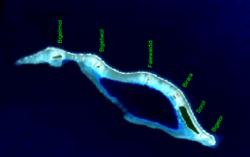
NASA picture of Sorol Atoll
|
|
|
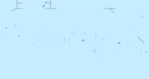
Location of Sorol in Yap State, Federated States of Micronesia
|
|
| Geography | |
|---|---|
| Location | North Pacific |
| Coordinates | 8°08′N 140°25′E / 8.133°N 140.417°E |
| Archipelago | Caroline |
| Total islands | 9 |
| Area | 0.934 km2 (0.361 sq mi) |
| Highest elevation | 2 m (7 ft) |
| Administration | |
| State | Yap |
| Demographics | |
| Population | 0 (2010) |
| Ethnic groups | Micronesian |
Sorol is a beautiful coral atoll made up of nine islands. It is located in the central Caroline Islands in the vast Pacific Ocean. Sorol is part of Yap State in the Federated States of Micronesia.
This atoll is about 150 kilometers (93 miles) south of Ulithi. It is also about 250 kilometers (155 miles) southeast of the main island of Yap. Sorol has not had people living on it since the early 1980s. It is officially a local government area, or municipality, within Yap State.
Contents
Exploring Sorol's Geography
Sorol Atoll stretches about 12.5 kilometers (7.8 miles) from east to west. It is up to 3.5 kilometers (2.2 miles) wide. The northern edge of the atoll is a long coral reef with several small islands.
The total land area of all the islands is quite small, only about 0.934 square kilometers (0.36 square miles). However, the atoll surrounds a deep lagoon that is 45 meters (148 feet) deep. This lagoon covers an area of about 7.1 square kilometers (2.7 square miles). The southern edge of the atoll is narrower and has two small openings into the lagoon. Only the four largest islands have plants growing on them.
Islands of Sorol Atoll
The individual islands that make up Sorol Atoll include:
- Bigelimol (the most northwestern island)
- Bigeliwol (in the northwest)
- Bigelor (the most southeastern island)
- Birara (in the south)
- Falewaidid (in the north)
- Sorol (in the southeast)
A Look at Sorol's History
The first time Sorol Island was officially seen by Europeans was on January 22, 1565. This sighting was made by a Spanish explorer named Alonso de Arellano. He was sailing on a ship called the San Lucas.
Changing Hands Over Time
Like all the Caroline Islands, Sorol was sold by Spain to the German Empire in 1899. After World War I, the island came under the control of the Empire of Japan. Japan then managed it as part of the South Seas Mandate.
After World War II, the United States of America took control of the island. It was managed as part of the Trust Territory of the Pacific Islands starting in 1947. Finally, in 1979, Sorol became part of the new country, the Federated States of Micronesia.
See also
 In Spanish: Sorol para niños
 | Bayard Rustin |
 | Jeannette Carter |
 | Jeremiah A. Brown |


