Soufrière Hills facts for kids
Quick facts for kids Soufrière Hills |
|
|---|---|
 |
|
| Highest point | |
| Elevation | 1,050 m (3,440 ft) |
| Prominence | 1,050 m (3,440 ft) |
| Geography | |
| Location | Montserrat, Caribbean |
| Country | |
| Geology | |
| Mountain type | Stratovolcano |
| Volcanic arc/belt | Lesser Antilles Volcanic Arc |
| Last eruption | 2013 |
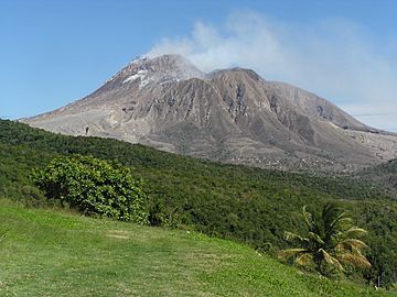
The Soufrière Hills volcano is a very active stratovolcano located on the Caribbean island of Montserrat. A stratovolcano is a tall, cone-shaped volcano built up by many layers of hardened lava and ash.
This volcano was quiet for a long time. But in 1995, it suddenly became active. It has been erupting on and off ever since. Because of these eruptions, people cannot live in the southern part of Montserrat. The island's capital city, Plymouth, was completely destroyed. About two-thirds of the people living on Montserrat had to leave their homes.
When the volcano erupted, it released very hot clouds of gas and ash. These dangerous clouds are called pyroclastic flows. They can be extremely hot, reaching temperatures of about 400 degrees Celsius (752 degrees Fahrenheit).
Contents
Understanding the Soufrière Hills Volcano
The Soufrière Hills volcano is part of a chain of volcanoes in the Caribbean. This chain is called the Lesser Antilles Volcanic Arc. It shows how Earth's plates move and create volcanoes.
What is a Stratovolcano?
A stratovolcano, like Soufrière Hills, is known for its steep sides. It forms from many layers of lava, ash, and rocks. These layers build up over thousands of years. When they erupt, stratovolcanoes can be very powerful.
When Did the Volcano Awaken?
The Soufrière Hills volcano was quiet for centuries. Scientists call this being "dormant." But in 1995, it started to show signs of waking up. It began to erupt, and these eruptions have continued for many years.
Impact of the Volcano's Eruptions
The eruptions of Soufrière Hills have changed Montserrat forever. They have had a huge impact on the island's land and its people.
Destroyed Capital City
The capital city of Montserrat, Plymouth, was directly in the path of the eruptions. It was buried under ash and mud. The city is now abandoned and unsafe. This shows how powerful and destructive volcanoes can be.
People Had to Move
Many people had to leave their homes because of the danger. About two out of every three people on Montserrat moved away. Some went to other parts of the island. Others moved to different countries. This was a very difficult time for them.
Understanding Pyroclastic Flows
One of the most dangerous things from the volcano is a pyroclastic flow. This is a fast-moving cloud of hot gas, ash, and rock. It rushes down the volcano's sides at high speeds. These flows are extremely hot and can destroy everything in their path.
Images for kids
-
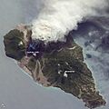
2009 ash and steam plume, Soufrière Hills Volcano. Grey deposits that include pyroclastic flows and volcanic mudflows (lahars) are visible extending from the volcano toward the coastline. NASA ISS photo, 11 October 2009, a view from the northeast looking southwest
-
Volcanic ash (tuff) from Montserrat
-
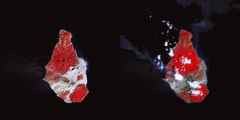
False colour satellite image of Soufrière Hills before and after a 2010 partial dome collapse. Red areas are living vegetation, grey areas are covered in volcanic debris
See also
 In Spanish: Soufrière Hills para niños
 | Misty Copeland |
 | Raven Wilkinson |
 | Debra Austin |
 | Aesha Ash |


