South Branch Township, Crawford County, Michigan facts for kids
There is also South Branch Township, Wexford County, Michigan.
Quick facts for kids
South Branch Township, Michigan
|
|
|---|---|

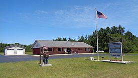
South Branch Township Hall
|
|

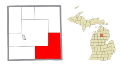
Location within Crawford County
|
|
| Country | United States |
| State | Michigan |
| County | Crawford |
| Established | 1876 |
| Area | |
| • Total | 105.56 sq mi (273.4 km2) |
| • Land | 104.83 sq mi (271.5 km2) |
| • Water | 0.73 sq mi (1.9 km2) |
| Elevation | 1,135 ft (346 m) |
| Population
(2020)
|
|
| • Total | 1,638 |
| • Density | 15.517/sq mi (5.9912/km2) |
| Time zone | UTC-5 (Eastern (EST)) |
| • Summer (DST) | UTC-4 (EDT) |
| Zip code(s) | |
| Area code(s) | 989 |
| FIPS code | 26-74760 |
| GNIS feature ID | 1627093 |
South Branch Township is a community in Crawford County, Michigan. It's a type of local government area called a civil township. In 2020, about 1,638 people lived here. The township is known for its beautiful natural areas and the Au Sable River.
Contents
Exploring South Branch Township's Communities
Deerheart Valley
- Deerheart Valley is a small area in the township that doesn't have its own local government. It's found along the south branch of the Au Sable River.
Eldorado: A Historic Community
- Eldorado is another small community in the township. It's located along M-18, a state highway.
- This area once had a post office called Jack Pine, which opened in 1885.
- Later, residents asked for the post office name to be changed to Eldorado. This name came from the idea of "a source of wealth," because of the many trees and lumber in the area.
- The post office was renamed Eldorado in 1908 and stayed open until 1952.
Geography and Natural Features
Land and Water Area
- South Branch Township covers about 105.56 square miles (273.40 square kilometers).
- Most of this area, about 104.83 square miles (271.51 square kilometers), is land.
- The rest, about 0.73 square miles (1.89 square kilometers), is water.
Location and Borders
- The township is in the southeast corner of Crawford County.
- It shares borders with Oscoda County to the east.
- To the south, it borders Roscommon County.
The Au Sable River
- South Branch Township gets its name from the South Branch of the Au Sable River.
- This river flows almost the entire length of the township.
- It starts in the southwest and flows north and east.
- Finally, it joins the main Au Sable River in the northern part of the township.
Local Attractions
- The Roscommon Zoo is located within South Branch Township, right along M-18. It's a fun place to visit!
Main Roads in the Township
- Important roads that go through South Branch Township include:
 M-18
M-18 M-72
M-72 F-97
F-97
Population and People
Township Population
- In 2020, the population of South Branch Township was 1,638 people.
- Back in 2000, there were 1,842 people living here.
- This means the population has changed a bit over the years.
Households and Families
- In 2000, there were 735 households in the township.
- A household is a group of people living together in one home.
- Most households were families, with many being married couples.
- The average household had about 2.51 people.
Age of Residents
- In 2000, the median age in the township was 43 years old.
- This means half the people were younger than 43, and half were older.
- About 24% of the population was under 18 years old.
- About 17.3% of the population was 65 years or older.
See also
 In Spanish: Municipio de South Branch (condado de Crawford) para niños
Black History Month on Kiddle
Renowned African-American Artists:
 | Selma Burke |
 | Pauline Powell Burns |
 | Frederick J. Brown |
 | Robert Blackburn |

All content from Kiddle encyclopedia articles (including the article images and facts) can be freely used under Attribution-ShareAlike license, unless stated otherwise. Cite this article:
South Branch Township, Crawford County, Michigan Facts for Kids. Kiddle Encyclopedia.


