South Calder Water facts for kids
Quick facts for kids South Calder Water |
|
|---|---|

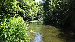
The river at Coltness
|
The South Calder Water is a river in Scotland. People who live nearby often call it "The Cawder" or just "Calder". This river starts on a high, flat area between Shotts and Fauldhouse. It then flows west until it meets the much bigger River Clyde.
The high ground where the South Calder Water begins is also where another river, the River Almond, starts. The River Almond flows in the opposite direction, heading east towards the River Forth.
Contents
What Does the Name "Calder" Mean?
The exact meaning of the name "Calder" isn't fully known. However, it most likely comes from an old language called Cumbric. This language was similar to modern Welsh. It was spoken in the Strathclyde area from the early Middle Ages until about the year 1200 AD.
In Cumbric, "caled dwr" means "hard water". This name might describe how strong the river's current is. Or, it could refer to the rocky riverbed found beneath the water.
A Look Back: The River's History
The South Calder Water has been around for a very long time, and it has seen many changes.
Ancient Roman Connections
Did you know that the ancient Romans built roads near this river? They made roads through areas like Wishaw and Motherwell. The remains of an old Roman fort, called the Bothwellhaugh Roman Fort, are located where the Calder meets the Clyde. Some people believe that a bridge crossing the river at Bothwellhaugh was built by the Romans. However, experts are not sure if the bridge is truly that old.
Wishaw House: A Grand Home
In the early 1600s, a large and fancy house was built right next to the river. It was named Wishaw House. The family who owned it also bought several farms nearby. This house was passed down through many generations of important families. Eventually, it was left empty and torn down in the 1950s.
Where Does the River Flow?
The South Calder Water doesn't flow for a very long distance. It travels about 10 miles. Along its journey, it winds around towns like Shotts, Wishaw, and Motherwell. Finally, it flows into Strathclyde Loch.
From Source to Loch
Near its start at Calderhead, the river flows through a wide valley. It passes by the villages of Bonkle and Murdostoun Castle. After Newmains, the river changes. It then cuts through a very deep and winding valley until it reaches Strathclyde Loch in Motherwell. This valley is found near parts of Wishaw, like Bonkle and Coltness.
The Underground River at Ravenscraig
At a place called Ravenscraig, the valley was filled in. This happened when the Ravenscraig steelworks were built, to create a large flat area. Because of this, the river now flows through a "cut and cover" tunnel. This means it goes underground for about half a mile beneath the old steelworks site. It then comes out again at Jerviston. If you drive across the Ravenscraig site today, you wouldn't even know there's a river flowing underneath!
Meeting Strathclyde Loch
The river's journey ends at Strathclyde Loch. In the past, the South Calder Water used to flow directly into the River Clyde. But in the 1960s, the River Clyde was moved about a mile to the west. This was done to create the large, man-made loch we see today. Now, the South Calder Water is the main source of water for Strathclyde Loch.
Places Named After the River
You can find the river's name in several places nearby. For example, there's Calder public park in Coursington (Motherwell). There's also Calderbridge Primary School in Coltness (Wishaw). And in Shotts, you'll find Calderhead High School.
 | Victor J. Glover |
 | Yvonne Cagle |
 | Jeanette Epps |
 | Bernard A. Harris Jr. |

