South Glens Falls, New York facts for kids
Quick facts for kids
South Glens Falls
|
|
|---|---|
|
Village
|
|
| Village of South Glens Falls | |

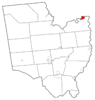
Map highlighting South Glens Falls' location within Saratoga County.
|
|
| Country | United States |
| State | New York |
| County | Saratoga |
| Area | |
| • Total | 1.49 sq mi (3.86 km2) |
| • Land | 1.36 sq mi (3.52 km2) |
| • Water | 0.13 sq mi (0.34 km2) |
| Elevation | 344 ft (105 m) |
| Population
(2020)
|
|
| • Total | 3,744 |
| • Density | 2,757.00/sq mi (1,064.15/km2) |
| Time zone | UTC-5 (Eastern (EST)) |
| • Summer (DST) | UTC-4 (EDT) |
| ZIP code |
12803
|
| Area code(s) | 518 |
| FIPS code | 36-69078 |
| GNIS feature ID | 0970626 |
South Glens Falls is a village in northern Saratoga County, New York. In 2020, about 3,744 people lived there. The village is surrounded by the Town of Moreau. The Hudson River separates it from the City of Glens Falls.
The village seal shows Cooper's Cave. This cave is named after the famous author James Fenimore Cooper. He visited the area and was inspired to use it in his novel, The Last of the Mohicans. The cave is in the bedrock of the Hudson River. You can see it from a special viewing platform under the bridge.
Contents
History of South Glens Falls
In ancient times, the area was a winter hunting ground. It was used by the Mohawk and Algonquian tribes. Later, people started to settle here. Goods were moved through the "Great Carry," which is now Route 9. This route connected Glens Falls and Fort Edward.
In 1766, the Daniel Parks family was the first to settle. They received about 800 acres (3.2 km²) of land. They built a house and a saw mill. By the mid-1830s, the settlement had many mills. There were saw mills, a grist mill, and a cotton mill. There was also a quarry and a dock for trade.
The Village officially became a village in 1895. This happened because people wanted to create a public water system. The Historical Society of Moreau and South Glens Falls is in the Parks-Bentley House. This house was added to the National Register of Historic Places in 1994.
Education in South Glens Falls
The South Glens Falls Central School District is approved by the New York State Education Department. It was officially started in 1945. The district covers about 70 square miles (180 km²). It serves the towns of Moreau, Northumberland, and Wilton.
The district has four elementary schools for grades K-5. It also has one middle school for grades 6-8. There is one high school for grades 9-12. About 3,350 students attend schools in the district. There are about 15 students for every teacher. More than half of the teachers have over 20 years of experience. The cost per student is low compared to other areas in Saratoga County. A nine-member board of education manages the district.
Elementary Schools
- Ballard Elementary School
- Harrison Avenue Elementary School
- Moreau Elementary School
- Tanglewood Elementary School
Middle School
- Oliver W. Winch Middle School
High School
- South Glens Falls Senior High School
South Glens Falls Senior High School is also known as South High. It hosts the yearly South High Marathon Dance. High school students raise money for families, individuals, or causes in need. The first event was in 1978. It raised about $1,500 for the local Emergency Squad. By 2020, the Marathon Dance had raised over $8.9 million in total.
Government and Public Services
The Village is led by a Mayor and a four-person Village Board. These leaders help make decisions for the community.
The village has its own police department, the South Glens Falls Police Department. The Moreau Emergency Squad provides medical help. The South Glens Falls Fire Company protects the village from fires.
Geography and Location
South Glens Falls is located at 43°17′47″N 73°38′3″W / 43.29639°N 73.63417°W. The village covers about 1.5 square miles (3.86 km²). Most of this area is land, and a small part is water.
The village is on the south bank of the Hudson River. You can reach it from exit 17N of Interstate 87. Several main roads meet in the village. These include U.S. Route 9, New York State Route 32, and County Road 28. All of these roads run north and south.
Population Information
As of the 2020 census, 3,744 people lived in the village. There were 1,599 households. About 90.6% of the people were White. About 1.12% were African American.
In the village, 21.7% of the population was under 18 years old. About 17.7% were 65 years or older. The average age was 38 years. The median income for a household was $31,623. About 10.6% of the population lived below the poverty line.
See also
 In Spanish: South Glens Falls para niños
 | Percy Lavon Julian |
 | Katherine Johnson |
 | George Washington Carver |
 | Annie Easley |


