South Holland IDB facts for kids
Quick facts for kids South Holland IDB |
|
|---|---|
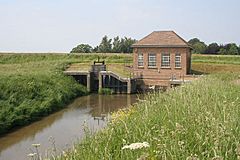
 Lord's Drain pumping station was built in 1962 and pumps into the River Welland. |
|
| OS grid reference | TF358248 |
| Shire county | |
| Region | |
| Country | England |
| Sovereign state | United Kingdom |
| EU Parliament | East Midlands |
The South Holland IDB is a special group in England. It's called an internal drainage board. Their main job is to manage water and stop floods in a large area of low-lying land in South Lincolnshire. This board was created under a law called the Land Drainage Act 1930.
What makes this area special is that it doesn't have big rivers flowing into it from higher places. This means the board only has to deal with the water that falls within its own area. The River Welland is on its west side, and the River Nene is on its east side.
Long ago, in Roman times, people lived along a path from Spalding to Sutton Bridge. This area was also mentioned in the Domesday Book. Later, starting in the 1600s, people began to claim and drain the salty marshland to the north. The Court of Sewers helped manage this drainage.
In 1793, the South Holland Drainage District was officially set up by a special law. They did a lot of drainage work. But they had problems because the River Nene's exit to the sea wasn't very good. A new exit was built in 1832. This allowed the district to lower their own water gates (sluices) in 1852. This helped water flow out better by gravity.
During and after the Second World War, more food was needed. So, large areas of grass fields were turned into farms. The drains were made deeper and wider to improve the soil. The main water gate was rebuilt again in 1937. For this project, a new method called "well point dewatering" was used for the first time in England. This method helps to dry out the ground during construction.
In 1949, the first electric pumping station was built. Many more followed. In July 1968, very heavy rain showed that the area could still flood. Because of this, more electric pumping stations were built. Today, more than half of the district relies on these pumps to prevent floods. Most stations can still let water out by gravity if the power goes out or a pump breaks down.
Contents
Where is South Holland?
The South Holland IDB looks after water drainage for an area of about 148.51 square miles (384.6 km2). This area is mostly around the town of Holbeach in Lincolnshire.
Its northern edge is along The Wash, which is part of the sea. The eastern edge follows the River Nene to Tydd Gote. From there, it turns west, going near Tydd St Mary and Sutton St James. Then it goes south to include Holbeach Drove and Shepeau Stow. After that, it turns north again to Whaplode Drove. From there, it goes west to the New River, following it north to the River Welland. The River Welland then forms the western edge back to The Wash.
Inside this area, most of the land (92%) is used for farming. The rest (8%) is for homes and businesses. The board takes care of 435 miles (700 km) of drainage channels. They also maintain 17 pumping stations and 30 sluices (water gates) and other structures. These help control water levels. The Environment Agency looks after the main rivers and 26 miles (42 km) of sea defenses. These defenses protect the area from the sea.
The area has main roads like the A151 road from Spalding to Holbeach. This road continues as the A17 to Long Sutton and crosses the River Nene at Sutton Bridge. From Holbeach, the A17 also goes northwest to cross the River Welland at Fosdyke.
A Look Back in Time
The path from Spalding to Long Sutton has been a place where people lived since Roman times. South of Whaplode and Holbeach, there's proof of many Roman settlements. This land is now about 7.1 and 10 feet (2.16 and 3.05 m) above sea level. It was protected by banks that Romans likely built. The Roman Bank to the north kept out the sea. The Raven Bank to the south separated the area from a low-lying fen. This fen often flooded from the Welland and Nene rivers. The area where people could live was about 5 miles (8 km) wide between these banks.
After the 300s, the land sank, causing floods. Some experts think farming didn't start again until the 1000s, as seen in the Domesday Book. But others believe that many place names with Saxon endings, like Weston and Holbeach, show that Saxon villages were thriving.
Salty marshes slowly grew north of the Roman Bank. They stretched about 2 and 5 miles (3 and 8 km) beyond it. These marshes were gradually enclosed, adding about 55 square miles (140 km2) of reclaimed land. Between the Roman Bank and the Raven Bank, the land was divided by walls. Each village built these walls to stop flooding if a nearby village didn't maintain its part of the main banks.
More land was enclosed over many years. In 1632, 1,121 acres (454 ha) were reclaimed in Tydd St Mary. In 1660, another 6,760 acres (2,740 ha) from Sutton and Lutton marshes were enclosed. Also in 1660, a much bigger project was done by "Adventurers". This covered 27.15 square miles (70.3 km2) in Gedney, Whaplode, Holbeach, and Moulton. Smaller areas were reclaimed in 1720, 1747, 1806, and 1865.
Early Drainage Efforts
Rules for maintaining flood defenses slowly came into place. In 1317, officials were chosen to check banks and drains in the marshes. They were to make any needed repairs. In 1571, an investigation was held to find out which drains and banks villages should maintain. It also said that landowners should fix sea banks every year. If they didn't, they would be penalized.
Around this time, George Carleton, who owned over 1,000 acres (400 ha), wanted to improve his land's drainage. He planned to dig drains south of Ravens Dyke. These would lead to a water gate with an engine at Sutton sea bank. The Lincolnshire Commission of Sewers didn't like "new ideas" and opposed his plan. This argument lasted for many years.
Carleton built a drainage engine where the Holbeach River met the sea bank. But it was destroyed in December 1587, just four days after it was finished. Someone cut through its main support beam. During the trial, it came out that Carleton had been threatened before. He had another plan for a drainage mill at Saturday Bridge. It was also clear that Carleton paid for the work himself. He didn't expect the village to pay for its upkeep.
In July 1578, Lord Burghley tried to solve the problem of the South Holland drain. He asked surveyors John Hexham and Ralph Agas to survey the area. Their findings mostly supported Carleton's ideas. Four special officials, including Carleton, were chosen to design the drain's path. They were helped by engineer Humphrey Bradley. But there's no proof that any work was done then. The drain wasn't built until 1793.
The Court of Sewers was generally in charge of drainage. But large parts of South Holland were separate. They got their own laws to allow specific work. This is how the Deeping Fen District and the South Holland Drainage District were created. The Court for the other areas was called the Hundred of Elloe. It met in Spalding.
South Holland Drainage District is Formed
The South Holland Drainage District was officially created by a law in 1793. At that time, the main drain was the Old Shire Drain. It had been dug in 1629 by the Adventurers of the Bedford Level. This drain was also known as the South Eau. It emptied into the River Nene at Tydd Gote through a sluice.
Before getting the law passed, landowners in South Holland hired George Maxwell and John Hudson to plan a drainage system. Maxwell was an engineer, and Hudson was a surveyor. They checked the area in November 1791. Then they hired others to do a full survey. They came back in August 1792. Maxwell measured that the proposed route would drop 8 feet (2.4 m) over 14 miles (23 km). The project was expected to cost nearly £18,000. Digging the drain cost £8,450, and building the sluice at Peters Point on the Nene cost £3,100. Their plans were well-liked and became the basis for the new law.
The law appointed Commissioners to make sure the district was drained. Three of them, including Maxwell, raised £38,400. The work started under the engineer Thomas Pear. The project took about three years. Pear died in 1795, and his son, also named Thomas Pear, finished the work. The drainage district was first 30.31 square miles (78.5 km2). Later, it grew to 56.87 square miles (147.3 km2).
The law also had a special rule for the Lord's Drain. This drain was owned by the Adventurers of Deeping Fen. Water from that fen flowed into it through a tunnel under the Welland. The Commissioners paid the Adventurers £1,500 and took over the drain. Besides the new main drain, which ran for 14 miles (23 km), the project included two other drains. The highland drain was 5 miles (8.0 km) long, and the lowland drain was 4 miles (6.4 km) long. Three bridges were built for roads. The main sluice, finished in 1795, had three arches and was 26 feet (7.9 m) wide.
The plan included drainage engines. One was in Sutton St Mary or Tydd, to pump the main drain into the Nene. The other was on the Lord's Drain. Landowners west of the Welland could still send water under the Welland to the Lord's Drain by paying a fee. To pay for the project, the Commissioners could charge a "land tax." This tax couldn't be more than £2 per acre over three years. It was based on how much each landowner would benefit.
The River Nene's exit to the sea wasn't good enough. So, a new one was built in 1832. The South Holland trustees paid £7,000 towards it. Because of this, they were allowed to lower their own water exit, which they did in 1852. The new sluice was 31 feet (9.4 m) wide. Its bottom was 6.33 feet (1.93 m) below sea level. This was about 5 feet (1.5 m) lower than the first sluice from 1795. This sluice controlled the drainage of 53.13 square miles (137.6 km2) of land. When high tides in the Nene stopped water from flowing out, levels in the drain would rise to 3.7 feet (1.1 m) above sea level.
At the very south of the drainage district is Sutton St Edmund. Its common lands were enclosed in 1797. A law was passed in 1809 to drain them. The first steam-powered pumping station in the Fens was built there in 1817. It pumped water into the South Holland Main Drain. It was a 10 or 12 hp (7.5 or 8.9 kW) machine. But it was removed in 1834/35 when the North Level Main Drain was built, and it was no longer needed.
New Laws and Modernisation
In 1927, a special group called a Royal Commission looked into land drainage in the United Kingdom. They found that the old laws were confusing and unfair. They suggested that new groups were needed. These groups would have the power and money to drain land well. They proposed having "catchment boards" for each main river. These boards would oversee smaller drainage boards. This idea was similar to what a committee had suggested in 1877.
The Land Drainage Act 1930 made these ideas into law. For South Holland, this meant five internal drainage boards were created: Holland Elloe IDB, South Holland IDB, South Holland Embankment Drainage Board, South Welland IDB, and Sutton Bridge IDB. From the early 1940s, these five boards worked together. They shared resources and workers when needed. On August 1, 1974, they all joined together to become the South Holland IDB we know today. There have been a few small changes to the area they cover and how they are organized since then.
How Drainage Changed
To help water flow out better by gravity, the sluice into the River Nene at Peters Point was rebuilt in 1937. It was made a bit narrower, 26 feet (7.92 m) wide. But its bottom was lowered to 10 feet (3.05 m) below sea level. The ground where the foundations were built was very silty. So, "well point dewatering" equipment was used for the first time in England. This method puts small tubes into the ground. A strong vacuum pump then lowers the water level in the ground. This creates a dry and stable place to work.
During the Second World War, more food was needed. This led to large areas of low-lying grass fields being plowed for crops. This meant better drainage was needed. The Main Drain Improvement Scheme was planned in 1942. The Main Drain and other channels were made wider and deeper. Ten new bridges were needed for the wider channels. Old brick structures were pulled down and replaced with open bridges. Feeder drains were improved. The area served by the drainage board grew to 63.28 square miles (163.9 km2).
The first electric pumping station was built in 1949. It was for a new exit for the Lawyers and Andersons areas. Several more followed. The Fleet Haven pumping station cost £21,793 and was finished in 1958/59. In the same year, Dawsmere pumping station cost £33,868. Lord's Drain pumping station started working in 1962. Sluices were also improved. The one on the Holbeach River was finished in 1955. The Lutton Leam outfall sluice followed in 1958/59.
Even with these improvements, the Fleet Fen area was still at risk of flooding. A big upgrade, paid for by the government, was finished in 1971. It included a new pumping station where the Main Drain and the Fleet River meet. This station used special "submersible pumps" for the first time in a land drainage project.
Very heavy rain on July 11, 1968, showed that more work was still needed. Over 4.9 inches (125 mm) of rain fell on Gedney in the early morning. Water from Spalding was sent into the Coronation Channel. This channel is a flood-relief bypass for the River Welland. Clay Lake pumping station was built in 1970. It handles this water. It can also pump the nearby fen when it's not busy. Five more pumping stations were built across the district.
Now, more than half of the area served by the IDB depends on pumping stations. But most stations can still let water out by gravity. This means power failures or breakdowns are not a disaster. Six more pumping stations have been built since 1974. The newest one started in July 2003 at Lawyers Sluice. It helps when the 1949 structure can't let water out due to high tides.
Pumping Stations
This table shows where the 16 pumping stations managed by the South Holland IDB are located. It also shows where they send the water.
| Point | Coordinates (Links to map resources) |
OS Grid Ref | Notes |
|---|---|---|---|
| Clay Lake PS | 52°46′38″N 0°08′33″W / 52.7772°N 0.1424°W | TF254215 | Into River Welland |
| Wisemans PS | 52°43′21″N 0°04′37″W / 52.7226°N 0.0770°W | TF299156 | On South Holland Main Drain |
| Peartree Hill PS | 52°43′26″N 0°02′16″W / 52.7239°N 0.0379°W | TF326158 | Into South Holland Main Drain |
| Gotts PS | 52°44′09″N 0°01′09″E / 52.7357°N 0.0192°E | TF364172 | Into South Holland Main Drain |
| Roses PS | 52°45′45″N 0°04′00″W / 52.7624°N 0.0668°W | TF305200 | Into Little South Holland Drain |
| Donningtons PS | 52°43′24″N 0°02′18″W / 52.7233°N 0.0382°W | TF325157 | Into South Holland Main Drain |
| Fleet Fen PS | 52°43′51″N 0°00′59″E / 52.7308°N 0.0163°E | TF362167 | Into South Holland Main Drain |
| Little Holland PS | 52°45′09″N 0°03′06″E / 52.7525°N 0.0517°E | TF385191 | Into South Holland Main Drain |
| Sutton St James PS | 52°45′09″N 0°03′12″E / 52.7524°N 0.0532°E | TF386191 | Into South Holland Main Drain |
| Westmere PS | 52°47′11″N 0°12′17″E / 52.7863°N 0.2048°E | TF487232 | Into River Nene |
| Dawsmere PS | 52°50′02″N 0°11′47″E / 52.8338°N 0.1965°E | TF480285 | Into The Wash |
| Fleet Haven PS | 52°52′27″N 0°08′09″E / 52.8743°N 0.1357°E | TF438328 | Into The Wash |
| Manor Farm PS | 52°50′07″N 0°04′47″E / 52.8353°N 0.0798°E | TF401284 | Into Fleet Haven tributary |
| Lawyers PS | 52°53′23″N 0°05′24″E / 52.8897°N 0.0900°E | TF407345 | Commissioned 2003. Into The Wash |
| Holbeach Bank PS | 52°49′52″N 0°00′36″E / 52.8311°N 0.0100°E | TF355278 | Into Whaplode River |
| Lords PS | 52°51′31″N 0°04′37″W / 52.8586°N 0.0769°W | TF295307 | Into River Welland |
 | Jessica Watkins |
 | Robert Henry Lawrence Jr. |
 | Mae Jemison |
 | Sian Proctor |
 | Guion Bluford |


