Ralph Agas facts for kids
Ralph Agas (born around 1540 – died 26 November 1621) was an English expert in measuring land and making maps. He was born in Stoke-by-Nayland, a village in Suffolk, England. He lived there his whole life, but often traveled to London for work. Agas started his career as a surveyor around 1566. He is known as one of the most important early land surveyors.
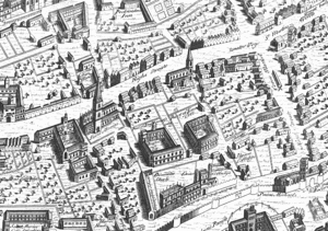
Agas is famous for his large, detailed map of Oxford. He drew this map in 1578, and it was printed in 1588. Some old maps of London and Cambridge were once thought to be his work, but experts now believe they were made by others.
Contents
Ralph Agas's Life Story
Agas was born in Stoke-by-Nayland, Suffolk, likely between 1540 and 1545. He started working as a land surveyor around 1566. Records show he had a physical disability, being described as "lame" or a "cripple." We don't know exactly what his disability was.
He was also a church leader, serving as a rector in Gressenhall, Norfolk, from 1578 to 1583. After this time, he likely focused fully on his surveying career.
Agas always lived in Suffolk. However, he often visited London to find new surveying jobs. During these trips, he stayed at inns. For example, in 1596, he stayed at the "Flower de Luce" near Fleet Bridge. In 1606, he stayed at the "Helmet" in Holborn.
Ralph Agas died in Stoke-by-Nayland on 26 November 1621. He was buried there the next day.
Agas's Famous Maps
Agas's main job was creating local estate maps for different clients. He was one of the first surveyors to draw detailed maps instead of just writing descriptions of land. His earliest known map is from 1575, showing lands at West Lexham, Norfolk. He worked in many counties, including Bedfordshire, Berkshire, Cambridgeshire, Essex, Gloucestershire, Norfolk, Oxfordshire, Suffolk, and Surrey.
One of his maps, made in 1581 for Toddington, Bedfordshire, shows a great picture of a small market town from the Elizabethan era. A powerful person named William Cecil, 1st Baron Burghley was one of his supporters. He also worked for Corpus Christi College, Oxford, though they only asked for written surveys, not maps.
The Oxford Map
Agas is best known for his detailed map of Oxford, called Oxonia Antiqua Restaurata. This map is like a "bird's-flight view" of the city. He drew it in 1578, and it was printed in 1588. A copy of this map is kept at the Bodleian Library in Oxford.
Other Attributed Maps
A map of Dunwich in Suffolk is also thought to be by Agas. This map was printed for a history book about the town in 1744.
Maps Not Made by Agas
For a long time, an important early map of London, known as the "Woodcut map," was believed to be Agas's work. A poem on Agas's 1588 Oxford map said he hoped to survey London. This led people to think he made the Woodcut map. However, experts now know the Woodcut map was made earlier, in the 1560s. It was based on an even older map from the 1550s. So, it's very unlikely Agas created it. Still, the Woodcut map is often incorrectly called the "Agas" map.
A map of Cambridge printed in 1592 was also once thought to be by Agas. But now, most experts believe John Hamond made it.
Agas's Writings and Ideas
Agas wrote several documents to tell people about his surveying services.
Advertising His Skills
His longest writing is a 20-page booklet from 1596, called A Preparative to Platting of Landes and Tenements for Surveigh. In it, he explained his surveying methods, including using a tool called the theodolite. He argued that maps were very helpful for landowners. He also criticized less skilled surveyors. He praised the theodolite for being more accurate than older tools.
He also wrote a shorter advertisement, which is undated. In it, Agas said he had over 40 years of experience. He claimed to know all about land ownership rules and could read old records well. He stressed how an experienced surveyor could help landowners avoid problems like hidden land or illegal takeovers.
Another advertisement, written by hand in 1606, shows his many skills. Besides surveying, Agas claimed he could read and fix old, damaged records. He could also find the weight and size of any solid object. He was good at math and could write very small. He even had a special recipe to protect eyesight! He said he could move heavy trees without harming them.
Other Important Documents
More of Agas's original writings are kept in the British Library. One is a letter from 1593 to Lord Burghley. It's about how to perfectly measure land and map cities and estates. In this letter, Agas describes using a "profitable staff" and a large theodolite. He also mentions using a steel wire for measuring.
In another letter to Burghley in 1597, Agas wrote about his work in the Fens (wetlands) of eastern England. He explained how he mapped the land and measured water levels. He thanked Burghley for payments but also mentioned that a lot of money was still owed to him.
His last known professional writing is from 1606. It's an opinion he gave to officials looking into hidden lands belonging to the King or Queen.
Agas's Personal Life
Ralph Agas was married, but his wife's name is not known. He had at least three sons, named Robert and Thomas, and two daughters. He is thought to be related to Edward Aggas, who was a bookseller and translator from the same area.
 | Roy Wilkins |
 | John Lewis |
 | Linda Carol Brown |


