
Dunwich facts for kids
Quick facts for kids Dunwich |
|
|---|---|
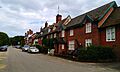
 Dunwich, view down St. James Street; to the right is the local museum |
|

Dunwich
|
|
| Population | 183 (2011 census) |
| OS grid reference | TM475705 |
| Civil parish |
|
| District |
|
| Shire county | |
| Region | |
| Country | England |
| Sovereign state | United Kingdom |
| Post town | SAXMUNDHAM |
| Postcode district | IP17 |
| Dialling code | 01728 |
| Police | Suffolk |
| Fire | Suffolk |
| Ambulance | East of England |
| EU Parliament | East of England |
| UK Parliament |
|
Dunwich is a small village in Suffolk, England. It is located on the North Sea coast, about 92 miles (148 km) north-east of London. Dunwich is part of the Suffolk Coast and Heaths Area of Outstanding Natural Beauty (AONB), which means it's a special place with beautiful natural scenery.
Long ago, Dunwich was a very important and busy port. It was even the capital of the Kingdom of the East Angles, an old kingdom in England during the Anglo-Saxon period. At its biggest, Dunwich was as large as London was in the 1300s. However, over many years, the sea has slowly washed away most of the town. This process is called coastal erosion. Big storms, especially in the late 1200s, caused a lot of damage and made the town shrink to the small village it is today. Some people think Dunwich might be connected to an ancient place called Dommoc.
In 2011, about 183 people lived in Dunwich. It doesn't have a local council like many towns. Instead, it has a "parish meeting" where local people discuss important matters.
Contents
History of Dunwich

Dunwich has a long and interesting history. Since the 1400s, many people have believed it was the ancient city of Dommoc. This was where the first Anglo-Saxon bishops of East Anglia had their main church around 629–31 AD. Bishops of Dommoc lived there until about 870 AD, when the Danes took over the East Anglian kingdom. For a long time, people called Dunwich the "former capital of East Anglia." However, some historians now think Dommoc might have been somewhere else, like Walton Castle.
Dunwich in the Domesday Book
In 1086, a famous old book called the Domesday Book described Dunwich as having three churches. At that time, it was a thriving town with an estimated 3,000 people.
The Great Storms
The decline of Dunwich began with a series of powerful storms. On January 1, 1286, a huge storm surge (a very high wave caused by a storm) hit the town. It destroyed many buildings. Before this, most damage to Dunwich was just land being lost and the harbour being harmed.
More storms followed in 1287, in February and December. Another fierce storm hit in 1328. Then, in 1347, a very large storm swept about 400 houses into the sea. The "Grote Mandrenke" (Great Drowning of Men) storm around January 16, 1362, finally destroyed much of what was left of the town.

Today, most of the buildings from the 1200s are gone, including all eight churches. Dunwich is now a small village. You can still see the remains of a 13th-century Franciscan priory (a type of monastery) called Greyfriars. You can also see parts of the Leper Hospital of St James. A popular local story says that on certain tides, you can still hear church bells ringing from under the waves.
It seems that the main reason Dunwich disappeared was not just the storms. The River Dunwich, which created a sheltered harbour, changed its course. It moved about 2.5 miles (4 km) north to Walberswick. When the river moved, Dunwich lost its main purpose as a port. People started to leave the town. Without people to maintain sea defences, the sea gradually washed away the remaining parts of the town.
Dunwich's Political Past
Even as it shrank, Dunwich kept its right to send two members to Parliament until 1832. It was known as a "rotten borough." This meant it was a place that had very few voters but still had a lot of power in Parliament. The town hall was lost to the sea, and the local government moved to a small cottage, which is now called the Old Town Hall, Dunwich.
By the mid-1800s, only 237 people lived in Dunwich. A new church, St James, was built in 1832. This was because the last of the old churches, All Saints', was no longer used. All Saints' Church eventually fell into the sea between 1904 and 1919. The last part of its tower fell on November 12, 1919. In 2005, a historian named Stuart Bacon said that recent low tides showed that ships were once built in Dunwich.
Exploring Underwater Dunwich

Since 2008, special projects have been trying to map and explore the lost town of Dunwich underwater. These projects use advanced technology to see what lies beneath the waves.
Underwater Surveys
One project, funded by English Heritage, used special tools like multibeam and sidescan sonar. These tools send sound waves to the seafloor to create detailed maps. They found many ruins that divers later confirmed were old stone buildings with medieval mortar (a type of cement).
In 2009, more surveys used even higher-resolution sonar. In 2010, the BBC used special acoustic imaging cameras (DIDSON) to film the ruins through the murky water. These cameras clearly showed piles of ruined blocks and carved stones from medieval churches and chapels.
What They Found
These surveys have created the most complete map of the Dunwich town site, which is the largest medieval underwater site in Europe. The Dunwich Museum displays maps and images from these surveys. It also shows how Dunwich fought against coastal erosion for 800 years.
In 2011, the TV show Time Team even filmed an episode about the Anglo-Saxon and medieval history of Dunwich. More work is planned to explore new sites and study the land around Dunwich. This work hopes to confirm the age of old town ditches and roads.
So far, these underwater explorations have found the ruins of St Peter's and St Nicholas's churches. They also found a chapel, probably St Katherine's, and ruins from the Blackfriars priory and the old town hall. The locations of the Knight's Templar Church and All Saints' Church are known from digital maps, but they are still buried under sand. It was discovered that Dunwich was a very important port even in Saxon times.
Old Buildings and Structures


Even though much of Dunwich is gone, some interesting historical remains can still be seen or have been found.
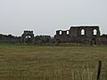
- Greyfriars: This was a Franciscan priory (a type of monastery) in the southwest of the city. Because it was so far west, it is one of the few important parts of old Dunwich that you can still see. It was founded in 1277 and moved to its current spot in 1290. It lasted until 1538 when King Henry VIII closed many monasteries. Much of its original stone wall is still there. The most impressive parts still standing are pieces of the dining hall (refectory) and the 14th-century gateway, which was the main entrance.
- St Bartholomew's and St Michael's: These were small chapels built by the end of the 1000s.
- St Leonard's: This was a parish church that fell into the sea in the 1300s.
- St Nicholas's: A parish church with a cross-shaped building. It was lost to the sea soon after the Black Death (a terrible plague) in the 1300s.
- St Martin's: This parish church was built before 1175. It was lost to the sea between 1335 and 1408.
- St Francis Chapel and St Katherine's Chapel: Both of these chapels were lost in the 1500s.
- St John the Baptist's: A large, cross-shaped parish church that was taken apart in the 1540s.
- Preceptory of the Knights Templar: This was a base for the Knights Templar, a famous group of knight-monks. It was thought to be founded around 1189 and was a round building, like the famous Temple Church in London. In 1322, the Templars' land was given to another group, the Knights Hospitallers. After King Henry VIII closed the monasteries, the Temple building was torn down in 1562. Its foundations were washed away by the sea later on.
- St Peter's: This was a parish church. People took anything valuable from it as the cliff edge got closer. The east wall fell in 1688, and the rest of the building followed in 1697. The church's old records (parish register) are now kept in the British Library.
- Blackfriars: This was a Dominican priory (another type of monastery) in the southeast of the city. It was founded during the time of King Henry III. Even though it was close to the sea, it remained active until King Henry VIII closed the monasteries. The last part of the building fell into the sea in 1717.
- All Saints' Church: This was the last of Dunwich's old churches to be lost to the sea. It was abandoned in the 1750s because people couldn't afford to keep it up. However, people were still buried in its churchyard until the 1820s. The cliff edge reached All Saints' in 1904. Its tower fell into the sea in 1922. One of the tower's supports (buttresses) was saved and is now at the current St James' Church. In 2022, only one gravestone remained, very close to the cliff edge.
RAF Dunwich
During the Second World War, there was an RAF (Royal Air Force) station called RAF Dunwich. It was one of the stations that provided low-level radar coverage for the East Anglian coast.
Dunwich Dynamo
The annual Dunwich Dynamo is a popular overnight bicycle ride. It starts in London and ends on Dunwich beach.
Images for kids
-
Dunwich, view down St. James Street; to the right is the local museum
-
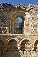
Former leper hospital, Norman window detail
-
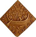
Seal of Dunwich, cast (French National Archives, Paris)
-
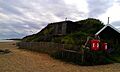
Beach at Dunwich
-
Remains of Greyfriars Priory
-
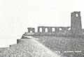
Ruins of All Saints' Church in Dunwich, here in a postcard of 1904
