
South Houston, Texas facts for kids
Quick facts for kids
South Houston, Texas
|
|
|---|---|

Marker for the city of South Houston
|
|

Location in Harris County and the state of Texas
|
|
| Country | |
| State | |
| County | Harris |
| Government | |
| • Type | Council-Manager |
| Area | |
| • Total | 3.05 sq mi (7.89 km2) |
| • Land | 3.05 sq mi (7.89 km2) |
| • Water | 0.00 sq mi (0.00 km2) |
| Elevation | 30 ft (9 m) |
| Population
(2020)
|
|
| • Total | 16,153 |
| • Density | 5,724.89/sq mi (2,210.20/km2) |
| Time zone | UTC-6 (Central (CST)) |
| • Summer (DST) | UTC-5 (CDT) |
| ZIP code |
77587
|
| Area codes | 713, 281, 832, 346 |
| FIPS code | 48-69020 |
| GNIS feature ID | 1347476 |
South Houston is a city in the state of Texas, in the United States. It is part of the larger Houston–The Woodlands–Sugar Land area and is located in Harris County. In 2020, about 16,153 people lived there. South Houston is next to the cities of Houston and Pasadena. It is found southeast of Houston.
Contents
History of South Houston
How South Houston Started
In 1907, a man named C.S. Woods started a settlement called Dumont. He worked for the Western Land Company. A post office opened there in 1910. In 1913, Dumont officially became a city and changed its name to South Houston.
Because South Houston became a city in 1913, the larger city of Houston could not take over its land. Houston did, however, add many nearby areas that were not yet cities.
Early Industries and Growth
At first, South Houston's main business was shipping farm products using the Galveston, Houston and Henderson Railroad. A big hurricane in 1915 damaged many local businesses.
Later, the creation of the Houston Ship Channel helped new factories and industries grow inland, including in South Houston. The city grew very quickly between the 1940s and the early 1960s. By 1960, about 7,523 people lived there. In 1980, the population was 11,782, and there were 303 businesses. By 1990, 14,207 people called South Houston home.
Elephants and Highways
Did you know that elephants helped build a road in South Houston? George Christy, a former mayor of South Houston, owned a circus. His elephants helped with the construction of the Spencer Highway.
Population Changes
From the 1980s to the 1990s, more and more Hispanic people moved to South Houston. Many of these new residents were of Mexican descent.
Geography of South Houston

South Houston is located at 29°39′40″N 95°13′47″W / 29.66111°N 95.22972°W. This is its exact spot on a map.
The United States Census Bureau says that the city covers about 7.8 square kilometers (3.0 square miles). All of this area is land, with no water.
People of South Houston
| Historical population | |||
|---|---|---|---|
| Census | Pop. | %± | |
| 1930 | 612 | — | |
| 1940 | 982 | 60.5% | |
| 1950 | 4,126 | 320.2% | |
| 1960 | 7,532 | 82.5% | |
| 1970 | 11,527 | 53.0% | |
| 1980 | 13,293 | 15.3% | |
| 1990 | 14,207 | 6.9% | |
| 2000 | 15,833 | 11.4% | |
| 2010 | 16,983 | 7.3% | |
| 2020 | 16,153 | −4.9% | |
| U.S. Decennial Census | |||


| Race | Number | Percentage |
|---|---|---|
| White (NH) | 1,128 | 6.98% |
| Black or African American (NH) | 330 | 2.04% |
| Native American or Alaska Native (NH) | 18 | 0.11% |
| Asian (NH) | 99 | 0.61% |
| Pacific Islander (NH) | 2 | 0.01% |
| Some Other Race (NH) | 32 | 0.2% |
| Mixed/Multi-Racial (NH) | 93 | 0.58% |
| Hispanic or Latino | 14,451 | 89.46% |
| Total | 16,153 |
In 2020, there were 16,153 people living in South Houston. There were 5,221 households and 4,107 families.
In 2010, there were 16,983 people and 4,617 households. About 89.4% of the people were Hispanic or Latino.
Many households (47.7%) had children under 18 living with them. The average household had 3.45 people. The average family had 3.86 people.
About 34.1% of the population was under 18 years old. The average age in the city was 28 years.
The average income for a household in the city was $44,607 (in 2017 dollars). About 24% of the people lived below the poverty line. This included 25.8% of those under 18.
Economy and Businesses
Local Businesses in South Houston
The main office for the Lewis Food Town grocery store chain is in South Houston.
In 2006, the H-E-B grocery store company opened a special store called "Mi Tienda" in South Houston. "Mi Tienda" means "My Store" in Spanish. This store has a Hispanic theme. By 2007, all the employees at Mi Tienda spoke Spanish.
Education in South Houston
Public Schools for Students

Students in South Houston attend schools that are part of the Pasadena Independent School District.
Elementary Schools
Several elementary schools serve different parts of South Houston:
- Pearl Hall Elementary School
- Walter Matthys Elementary School (opened in 1992)
- L.F. Smith Elementary School
- South Houston Elementary School
South Houston Elementary School had computers in all classrooms and a student-run broadcasting studio by 2000. Even though many students came from families with lower incomes, the school earned "recognized" scores from the Texas Education Agency in 1999–2000.
Middle and Intermediate Schools
Some parts of South Houston (west of Old Galveston Road) go to Rick Schneider Middle School in Houston for grades 5–6. Other parts go to Carter Lomax Middle School in Pasadena for grades 5–6.
For grades 7–8, students west of Old Galveston Road attend South Houston Intermediate School. Students east of Old Galveston Road go to Queens Intermediate School in Pasadena for grades 6–8. South Houston Intermediate School is on land that used to be an old college and other places before it became a school.
High School
All students in South Houston attend South Houston High School.
Public Libraries

South Houston has its own branch of the Harris County Public Library. It is located at 607 Avenue A. The first library in South Houston opened in 1927. A special building was built for the library in 1937. The current library building opened in May 1991 and is about 5,800 square feet (539 square meters).
Colleges and Universities
After high school, students from South Houston can attend San Jacinto College.
Gallery of Schools
-
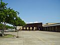
South Houston Elementary School
-
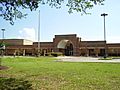
Walter Matthys Elementary School
-
L. F. Smith Elementary School
-
Pearl Hall Elementary School
-

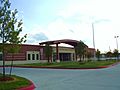
South Houston Intermediate School


Transportation
Harris County Transit provides public transportation services in South Houston.
Gallery
-
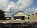
South Houston Police Department front entrance
-
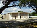
South Houston Municipal Court


See also
 In Spanish: South Houston (Texas) para niños
