
South Mountain (La Sal Mountains) facts for kids
Quick facts for kids South Mountain |
|
|---|---|

South Mountain, west aspect
|
|
| Highest point | |
| Elevation | 11,798 ft (3,596 m) |
| Prominence | 1,657 ft (505 m) |
| Isolation | 2.45 mi (3.94 km) |
| Parent peak | Mount Tukuhnikivatz |
| Geography | |

South Mountain
Location in Utah

South Mountain
Location in the United States
|
|
| Location | San Juan County, Utah |
| Parent range | La Sal Mountains |
| Topo map | USGS Mount Tukuhnikivatz |
| Climbing | |
| Easiest route | class 2 |
South Mountain is a tall mountain peak located in San Juan County, Utah, in the United States. It stands about 11,798-foot (3,596 m) (that's over 3,500 meters!) high. This mountain is part of the La Sal Mountains range.
It is located about 5 miles (8.0 km) north of a small place called La Sal, Utah. The nearest big town is Moab, which is about 20 mi (32 km) to the northwest. Water from rain and melting snow on South Mountain flows into streams that eventually reach the mighty Colorado River. Its closest tall neighbor is Mount Tukuhnikivatz, located 2.64 mi (4.25 km) to the north.
Mountain Weather and Climate
The best times to visit the South Mountain area are during spring and fall. The weather is usually mild and pleasant then.
This region has a type of weather called a Cold semi-arid climate. This means it's a desert climate, but it can get quite cold in winter. The coldest month often has an average temperature below 32 °F (0 °C). Also, more than half of the year's rain and snow falls during spring and summer.
Even though it gets some rain, this desert area receives less than 10 inches (250 millimeters) of rainfall each year. Snowfall in winter is usually not very heavy.
Views of South Mountain
-
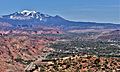
South Mountain can be seen in the distance beyond the town of Moab.
-
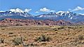
Mount Tukuhnikivatz is on the left, and South Mountain is on the right.
-
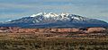
A view of the south side of the mountain.


