
Mount Tukuhnikivatz facts for kids
Quick facts for kids Mount Tukuhnikivatz |
|
|---|---|

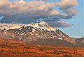
West aspect, from Highway 191
|
|
| Highest point | |
| Elevation | 12,482 ft (3,805 m) |
| Prominence | 722 ft (220 m) |
| Isolation | 1.67 mi (2.69 km) |
| Parent peak | Mount Peale (12,721 ft) |
| Geography | |

Mount Tukuhnikivatz
Location in Utah

Mount Tukuhnikivatz
Location in the United States
|
|
| Location | San Juan County, Utah, U.S. |
| Parent range | La Sal Mountains |
| Topo map | USGS Mount Tukuhnikivatz |
| Geology | |
| Age of rock | Oligocene |
| Mountain type | Laccolith |
| Type of rock | igneous |
| Climbing | |
| Easiest route | class 2 scrambling |
Mount Tukuhnikivatz is a tall mountain peak in Utah, United States. It stands 12,482 feet (3,805 meters) high. This mountain is located in San Juan County. It is the third-highest peak in the La Sal Mountains range.
Many people enjoy ski mountaineering here. The mountain is part of the Manti-La Sal National Forest. Water from the mountain flows into the Colorado River. The closest town is Moab, about 19 miles (31 km) away. The name "Tukuhnikivatz" comes from a Native American word. It means "Where the sun sets last." Locals often call it "Mount Tuk" for short. There is also a smaller peak nearby called Little Tuk, which is 12,048 feet high.
Mountain Weather and Seasons
The best times to visit Mount Tukuhnikivatz are spring and fall. The mountain has a Cold semi-arid climate. This means winters are cold, with average temperatures below freezing. Most of the yearly rain and snow falls in spring and summer.
This area is like a desert, getting less than 10 inches (250 mm) of rain each year. Snowfall in winter is usually not very heavy.
Gallery
-
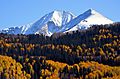
Mt. Tukuhnikivatz and Little Tuk (right), from the north
-
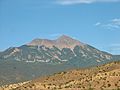
Tukuhnikivatz from southwest
-
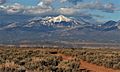
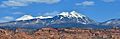
West aspect, Mt. Tukuhnikivatz centered, Mt. Peale to right
-
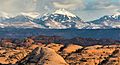
From northwest, with petrified dunes in foreground
-
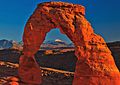
Mt. Tukuhnikivatz framed by Delicate Arch
-
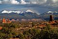
Mt. Tukuhnikivatz centered, from Arches National Park
-
Little Tuk (left) and Mt. Tukuhnikivatz in summer.
-
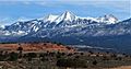
Mt. Tukuhnikivatz, with Mt. Mellenthin to the left

.jpg)


Images for kids
-
Tukuhnikivatz at sunset

