
Mount Mellenthin facts for kids
Quick facts for kids Mount Mellenthin |
|
|---|---|

West aspect
|
|
| Highest point | |
| Elevation | 12,645 ft (3,854 m) |
| Prominence | 645 ft (197 m) |
| Isolation | 1.75 mi (2.82 km) |
| Parent peak | Mount Peale (12,721 ft) |
| Geography | |

Mount Mellenthin
Location in Utah

Mount Mellenthin
Location in the United States
|
|
| Location | San Juan County, Utah, U.S. |
| Parent range | La Sal Mountains |
| Topo map | USGS Mount Peale |
| Geology | |
| Age of rock | Oligocene |
| Mountain type | Laccolith |
| Climbing | |
| Easiest route | class 2 |
Mount Mellenthin is a tall mountain peak in Utah, United States. It stands 12,645 feet (3,854 meters) high. This makes it the second-highest peak in the La Sal Mountains. You can find it in San Juan County.
The mountain is part of the Manti-La Sal National Forest. It is in a dry, wild area with few people. Water from the mountain flows into streams that lead to the Colorado River. The closest town is Moab, about 20 miles (32 km) away. The highest mountain nearby is Mount Peale, which is about 1.7 miles (2.7 km) to the south.
Mount Mellenthin is named after Rudolf E. Mellenthin. He was a forest ranger for the La Sal National Forest. The mountain was officially given its name in 1932. This was done by the United States Board on Geographic Names.
Mountain Weather
The best times to visit Mount Mellenthin are spring and fall. The mountain is in a cold semi-arid climate zone. This means the coldest month has an average temperature below 32 °F (0 °C). Also, most of the yearly rain and snow falls during spring and summer.
This desert climate gets less than 10 inches (254 mm) of rain each year. Snowfall is usually light during the winter months.
Images for kids
-
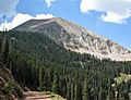
East side of Mount Mellenthin
-
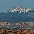
Mount Mellenthin seen from Arches National Park
-
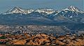
Mount Mellenthin (left) and Mount Tukuhnikivatz (right)


