
Southport, New York facts for kids
Quick facts for kids
Southport, New York
|
||
|---|---|---|

Southport Town Hall
|
||
|
||

Southport, New York
Location in New York
|
||
| Country | United States | |
| State | New York | |
| County | Chemung | |
| Government | ||
| • Type | Town Council | |
| Area | ||
| • Total | 46.84 sq mi (121.31 km2) | |
| • Land | 46.41 sq mi (120.21 km2) | |
| • Water | 0.43 sq mi (1.10 km2) | |
| Elevation | 1,073 ft (327 m) | |
| Population
(2020)
|
||
| • Total | 9,684 |
|
| • Estimate
(2021)
|
9,515 | |
| • Density | 224.40/sq mi (86.64/km2) | |
| Time zone | UTC-5 (Eastern (EST)) | |
| • Summer (DST) | UTC-4 (EDT) | |
| FIPS code | 36-015-69617 | |
| GNIS feature ID | 0979509 | |
Southport is a small town located in Chemung County, New York, in the United States. In 2020, about 9,684 people lived there. The town is in the southwest part of Chemung County. It is also southwest of the city of Elmira. Southport is part of the larger Elmira area.
Contents
History of Southport
The first people settled in the Southport area around 1788. The town of Southport was officially created in 1822. It was formed from a part of the town of Elmira. Later, in 1867, a section from the eastern part of Southport was used to help create the new town of Ashland.
Geography and Location
Southport covers a total area of about 121.3 square kilometers (46.8 square miles). Most of this area, about 120.2 square kilometers (46.4 square miles), is land. The rest is water.
The southern border of Southport touches the state of Pennsylvania. The western border of the town is shared with Steuben County. The Chemung River flows along part of the northern border. This river is a branch of the Susquehanna River.
Two main roads, New York State Route 14 and New York State Route 328, run north-south through Southport. They meet in the village of Southport.
How Many People Live in Southport?
| Historical population | |||
|---|---|---|---|
| Census | Pop. | %± | |
| 1830 | 1,454 | — | |
| 1840 | 2,101 | 44.5% | |
| 1850 | 3,184 | 51.5% | |
| 1860 | 4,733 | 48.6% | |
| 1870 | 2,185 | −53.8% | |
| 1880 | 3,619 | 65.6% | |
| 1890 | 2,044 | −43.5% | |
| 1900 | 2,201 | 7.7% | |
| 1910 | 2,034 | −7.6% | |
| 1920 | 3,084 | 51.6% | |
| 1930 | 5,421 | 75.8% | |
| 1940 | 5,774 | 6.5% | |
| 1950 | 9,164 | 58.7% | |
| 1960 | 11,433 | 24.8% | |
| 1970 | 11,976 | 4.7% | |
| 1980 | 11,586 | −3.3% | |
| 1990 | 11,571 | −0.1% | |
| 2000 | 11,185 | −3.3% | |
| 2010 | 10,940 | −2.2% | |
| 2020 | 9,684 | −11.5% | |
| 2021 (est.) | 9,515 | −13.0% | |
| U.S. Decennial Census | |||
In the year 2000, there were 11,185 people living in Southport. These people lived in 4,189 households. About 28.6% of these households had children under 18 years old. Most people in Southport were White (90.55%). About 6.78% were Black or African American.
The average age of people in Southport in 2000 was 40 years old. About 21.2% of the population was under 18 years old.
Places and Communities in Southport
Southport has several smaller communities and interesting spots:
- Bulkhead – This used to be a community in the town.
- Mudlick Creek – A stream that flows out of the western part of the town.
- Mount Zoar – A tall hill located in the northern part of Southport.
- Pine City – A small village located between Southport village and Webb Mills. It is named for the many pine trees in the area.
- Rosstown – A place found south of Southport on County Road 26.
- Sagetown – A location near the western town line, close to Mudlick Creek.
- Seeley Creek – This name refers to two things:
- A stream that flows north through the town to the Chemung River.
- A small village south of Webb Mills. It is named after an early family who settled there.
- Southport – This is the main village of Southport. It is in the northeastern part of the town and is a suburb of Elmira.
- Webb Mills – A village in the south-central part of the town, north of Seeley Creek.
Images for kids
-
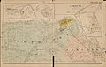
Map showing the Town of Southport, with Ashland, 1904

See also
 In Spanish: Southport (pueblo) para niños
