
Sperry Glacier facts for kids
Quick facts for kids Sperry Glacier |
|
|---|---|

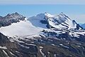
Sperry Glacier beneath snowy Gunsight Mountain - September 8, 2008
|
|
| Type | Mountain glacier |
| Location | Glacier National Park, Flathead County, Montana, United States |
| Coordinates | 48°37′23″N 113°45′44″W / 48.62306°N 113.76222°W |
| Area | 216 acres (0.87 km2) in 2005 |
| Terminus | Talus |
| Status | Retreating |
Sperry Glacier is a large glacier found in Glacier National Park in Montana, a state in the United States. It sits on the northern slopes of Gunsight Mountain. While many features in the park were shaped by ice ages long ago, Sperry Glacier formed more recently. It grew during a cooler time called the Little Ice Age, which lasted from about the 1200s to the mid-1800s.
Sperry Glacier used to be one of the biggest glaciers in the park. However, it has shrunk a lot since the mid-1800s. Its size has gone down by about 75 percent. In 2005, the glacier was measured to be about 216 acres (0.87 km2). Back in the mid-1800s, it was much larger, covering about 930 acres (3.8 km2). This means it lost almost 35 percent of its size between 1966 and 2005 alone. The glacier is named after Lyman B. Sperry, a professor who explored and mapped the area in 1895. As Sperry Glacier melts, it leaves behind cool features like large piles of rock called moraines. It also creates streams and lakes with a milky blue color from tiny rock dust. Unlike some other glaciers, Sperry Glacier is high up, so you won't see icebergs floating in the lakes below it.
Contents
Exploring Sperry Glacier: A Hiking Adventure

Many hikers enjoy visiting Sperry Glacier. Some choose to stay overnight at Sperry Chalet or its nearby campground. This helps them get an early start for the hike to the glacier.
The Trail to Sperry Glacier
The hike from Sperry Chalet to Sperry Glacier is about 7 miles (11 km) round-trip. It is a challenging trail because it is very steep. You will climb about 1,600 feet (490 m) in just 2.5 miles (4.0 km). Along the way, you will see beautiful glacial cirques. These are bowl-shaped valleys carved by glaciers. They have streams, waterfalls, and lakes that reflect the snowy peaks.
Reaching the Glacier's Edge
As you get closer, you will find a narrow stone staircase. It is cut right into the rock ridge of Comeau Pass. From the top of these steps, you get amazing views. You can see mountains like Mount Brown, Edwards Mountain, and Little Matterhorn. To reach the glacier itself, you will need to cross rocky areas and snowfields. It can be tricky, so it's important to follow the rock piles called cairns. These markers show you the safest and easiest paths. Park rangers also lead hikes from the chalet, which can be very helpful.
Longer Hikes to Floral Park
For hikers who want a bigger adventure, there is a longer route to the glacier. This route also takes you through an area called Floral Park. You can start this long day hike from Logan Pass. The path goes along the western edge of Hidden Lake. Then, it climbs up along Bearhat Mountain and crosses a part of the Dragon's Tail. From there, the trail goes down into Floral Park. After carefully walking across the bottom of the glacier, you can leave the area through Comeau Pass. This path leads you down to the Going-to-the-Sun Road near Lake McDonald. This longer route is about 20 miles (32 km) and is very demanding.
Images for kids
-
Sperry Glacier beneath snowy Gunsight Mountain - September 8, 2008
See also
 In Spanish: Glaciar Sperry para niños
