
Springer Mountain facts for kids
Quick facts for kids Springer Mountain |
|
|---|---|

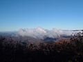
Springer Mountain viewed from East Ellijay
|
|
| Highest point | |
| Elevation | 3,782 ft (1,153 m) NAVD 88 |
| Geography | |

Springer Mountain
Location in Georgia (U.S. state)
|
|
| Location | Fannin/Gilmer counties, Georgia, U.S. |
| Parent range | Blue Ridge Mountains |
| Topo map | USGS Noontootla |
| Climbing | |
| First ascent | unknown |
| Easiest route | Appalachian Trail |
Springer Mountain is a cool mountain in northern Georgia. It sits right on the edge of Fannin and Gilmer counties. This mountain is part of the beautiful Blue Ridge Mountains. It's also found within the Chattahoochee National Forest. Springer Mountain is about 3,782 feet (1,153 m) tall. It's super important because it's the starting point for two famous long-distance hiking paths: the Appalachian Trail and the Benton MacKaye Trail.
Contents
What's in a Name?
The exact reason for Springer Mountain's name isn't fully known. There are a couple of ideas about where the name came from.
One idea is that it was named after William G. Springer. He was an early settler who helped make laws better for Native Americans in 1833. Another idea is that the mountain was named for John Springer. He was the first Presbyterian minister to become a minister in Georgia, back in 1790.
People have been calling it Springer Mountain since at least 1910. But even in 1959, some people in Gilmer County still called it Penitentiary Mountain. The Georgia Appalachian Trail Club (GATC) officially changed the name. No one knows why it was called Penitentiary Mountain before. Also, there isn't a known Cherokee name for the mountain.
Where is Springer Mountain?
Springer Mountain is shaped a bit like a loaf of bread. It runs from north to south. You can find it right on the border of Gilmer and Fannin counties. The top of the mountain is about 3,782 feet (1,153 m) above sea level.
This mountain is part of the large Blue Ridge Mountains range. This range stretches all the way from Georgia to Pennsylvania. Springer Mountain helps divide the Blue Ridge Mountains in Georgia. One part goes northwest towards the Cohutta Mountains. The other part goes southwest towards Mount Oglethorpe. Springer Mountain is inside the Chattahoochee National Forest. It's also part of the Ed Jenkins National Recreation Area.
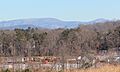
The mountain is about 17 miles (27 km) east of Ellijay. It's also about 14 miles (23 km) northwest of Dahlonega. And it's 11 miles (18 km) southwest of Suches. Mount Oglethorpe was the first southern end of the Appalachian Trail. It's located about 14 miles (23 km) south of Springer Mountain. Other cool places nearby include Black Mountain, Tickanetley Creek, and Winding Stair Gap.
Hiking Adventures
Springer Mountain is a popular spot for hikers. It's the starting point for two very long and famous trails.
The Appalachian Trail

In 1958, the starting point of the Appalachian Trail was moved. It used to be at Mount Oglethorpe. But it was moved to Springer Mountain. This happened because more buildings were being built around Mount Oglethorpe. Springer Mountain was chosen because it was more remote. This meant it was less likely to have new buildings built near it.
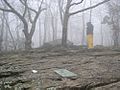
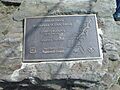
One way to reach the top of Springer Mountain is from a parking lot. This lot is on Forest Service Road 42. From there, it's a 0.9 miles (1.4 km) hike south on the Appalachian Trail to the summit. Hikers who want to start their journey north on the Appalachian Trail first walk south to the peak. Then they turn around and head north. At the very top of Springer Mountain, you'll find a bronze plaque with the Appalachian Trail logo. There's also a book for hikers to sign and a special marker.
You can also reach Springer Mountain from the south. This is by using the Appalachian Approach Trail. This trail starts at the visitor's center of Amicalola Falls State Park. It is about 8.5 miles (13.7 km) long.
The Benton MacKaye Trail
Springer Mountain is also the southern starting point for the Benton MacKaye Trail. The beginning of this trail is about 0.3 miles (0.48 km) north of the mountain's summit.
Shelters for Hikers
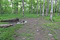
If you're hiking and need a place to rest, there are shelters nearby. The closest one is the Springer Mountain Shelter. It's about 0.2 miles (0.32 km) north of the summit. There's also a water spring near this shelter. Another shelter is the Black Gap Shelter. It's about 1.5 miles (2.4 km) south of the summit. You can find it on the Appalachian Approach Trail.
Images for kids
-
A hiker signs the Appalachian Trail register at Springer Mountain
-
Appalachian Trail marker
-
Campsite on top of the mountain
-
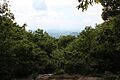
View from Springer Mountain in May
-
View from Springer Mountain in November
-
Springer Mountain (left) and Black Mountain (right) covered in snow. Viewed from East Ellijay


.jpg)


.jpg)
