
Mount Oglethorpe facts for kids
Quick facts for kids Mount Oglethorpe |
|
|---|---|

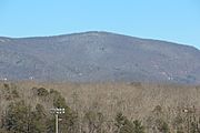
Mount Oglethorpe in October
|
|
| Highest point | |
| Elevation | 3,288 ft (1,002 m) |
| Prominence | 1,258 ft |
| Geography | |

Mount Oglethorpe
Location in Georgia (U.S. state)
|
|
| Location | Pickens County, Georgia, U.S. |
| Parent range | Blue Ridge Mountains |
| Topo map | USGS Nelson |
| Climbing | |
| Easiest route | Drive |
Mount Oglethorpe is a cool mountain in Pickens County, Georgia, USA. It's the very first mountain at the southern end of the Blue Ridge Mountains. Standing tall at about 3,288 feet (1,002 meters), it's the highest spot in Pickens County!
For many years, from 1937 to 1958, Mount Oglethorpe was the official starting point for the famous Appalachian Trail. But because of too much building around the mountain, the trail's starting point was moved in 1958. It moved about 13 miles (21 km) northeast to Springer Mountain.
Contents
Where is Mount Oglethorpe?
Mount Oglethorpe is located in eastern Pickens County. It's close to the border with Dawson County. The mountain is about 6 miles (10 km) east of Jasper. It's also about 13 miles (21 km) west of Dawsonville. You can find it about 7 miles (11 km) north of Nelson.
South of the mountain, you can find marble quarries. These are places where marble is dug out of the ground. The community of Bent Tree is on the western side of the mountain. Big Canoe is on the eastern side. Springer Mountain, where the Appalachian Trail now starts, is about 13 miles (21 km) northeast.
Other mountains nearby include Burnt Mountain and Sharptop Mountain. Mount Oglethorpe's very top isn't on protected land. But its northeastern slopes are part of the Dawson Forest Wildlife Management Area. This area helps protect animals and nature.
At 3,288 feet (1,002 meters) high, Mount Oglethorpe is the tallest mountain in Pickens County. It's also known as the southern end of the beautiful Blue Ridge Mountains.
Mountain History
Early Days of Mount Oglethorpe

The Cherokee people lived on Mount Oglethorpe as far back as the 1700s. They would bend trees to mark their trails and places to stay on the mountain. Later, white settlers started moving into the area. This happened after the Georgia Land Lotteries in the early 1800s.
Mount Oglethorpe was first called Grassy Knob. In 1930, its name changed to Mount Oglethorpe. This was to honor James Oglethorpe, who founded the Georgia Colony. In the same year, a tall marble obelisk was built on the mountain's top. It was 38 feet (12 meters) high and called the Oglethorpe Monument.
Mount Oglethorpe and the Appalachian Trail
In 1930, Mount Oglethorpe was chosen as the southern end of the Appalachian Trail. This famous hiking trail stretches for thousands of miles. Mount Oglethorpe wasn't the only idea for the trail's start. Some people thought about Mount Mitchell in North Carolina.
There were good reasons to pick Mount Oglethorpe. It was seen as the true southern tip of the Blue Ridge Mountains. A powerful local businessman named Sam Tate also helped with the decision. He was the president of the Georgia Marble Company. Tate wanted to build a resort nearby. He hoped the trail would pass by his new resort. To help convince the Georgia Appalachian Trail Club, Tate gave money. He also let the trail go through his private land.
In 1937, the Appalachian Trail was finished. Mount Oglethorpe officially became its southern starting point. Famous early hikers like Grandma Gatewood and Earl Shaffer began their long journeys here.
However, Mount Oglethorpe was not on protected land. This meant it was open for building. In the 1950s, companies bought land there for logging and chicken farms. A new gravel road led to damage on the mountain. Because of all this building, the Georgia Appalachian Trail Club decided to move the trailhead.
In 1958, the trail leaders chose Springer Mountain as the new starting point. Springer Mountain was about a 20-mile (32 km) hike north. It was considered less exciting than Mount Oglethorpe. But it was also more remote. This meant it was less likely to be developed. Today, the only part of the old trail that remains is the Appalachian Approach Trail. It runs between Amicalola Falls State Park and Springer Mountain.
Life After the Appalachian Trail
After the trail moved, communication towers were built on Mount Oglethorpe's top. In the 1970s, the Big Canoe community started building homes on the eastern side. The Oglethorpe Monument was damaged by weather and lightning. So, in 1999, it was moved to downtown Jasper. Parts of the old Appalachian Trail became closed to the public. The mountain's summit was also closed.
In 1995, Ken Rice and his wife Billie Ann bought about 107 acres (43 ha) of land near the summit. In 2014, the Rices opened their land to the public. They named it Eagle's Rest. This public park has hiking trails and observation decks.
Visiting Mount Oglethorpe
Before 2014, you couldn't easily visit the summit without going onto private land. Now, it's open to everyone! You can reach Mount Oglethorpe's summit by driving south from Georgia State Route 136. Take Monument Road for about 5 miles (8 km). You can also get to the summit from the south through Big Canoe.
Gallery
-
Mount Oglethorpe with a dusting of snow.
-
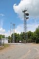
Communication towers on the summit
-
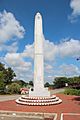
The Oglethorpe Monument. Formerly on Mount Oglethorpe's summit, the monument is now located in Jasper
.jpg)


