
Square Butte (Arizona) facts for kids
Quick facts for kids Square Butte |
|
|---|---|
| Tsé Dikʼání | |

Southeast aspect
|
|
| Highest point | |
| Elevation | 7,140 ft (2,180 m) |
| Prominence | 400 ft (120 m) |
| Isolation | 1.76 mi (2.83 km) |
| Parent peak | White Mesa |
| Geography | |

Square Butte
Location in Arizona

Square Butte
Location in the United States
|
|
| Location | Navajo Reservation Coconino County, Arizona, U.S. |
| Parent range | Colorado Plateau |
| Topo map | USGS Square Butte |
| Geology | |
| Age of rock | Jurassic |
| Type of rock | Entrada Sandstone |
Square Butte is a tall sandstone mountain in northern Arizona. It stands 7,140 feet (2,176 meters) high. This landmark is located on land belonging to the Navajo Nation, in Coconino County.
The mountain is about 35 miles (56 km) southeast of the town of Page. It is also 9 miles (14 km) east of Kaibito. Square Butte rises more than 700 feet (213 meters) above the land around it. You can easily spot it from Arizona State Route 98.
In the Navajo language, Square Butte is called Tsé Dikʼání. This name means "square rock," which describes its shape well. The closest taller mountain is White Mesa, which is about 2 miles (3 km) to the south.
Rain and snow that fall on Square Butte flow into nearby washes and canyons. This water eventually reaches Lake Powell and the Colorado River. The area around Square Butte has a dry climate. Summers are hot and very dry, while winters are cold. The best times to visit are spring and fall.
The top of Square Butte is made of a type of rock called Entrada Sandstone. Below it is another rock layer called Carmel Formation. Both of these rocks formed a very long time ago, during the Jurassic period. This was the time when dinosaurs roamed the Earth!
Gallery
-
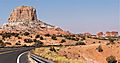
From Highway 98, with Setting Red Rocks to right
-
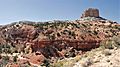
Note exposed Carmel Formation


