
St. Anthony Falls Hydroelectric Development facts for kids
St. Anthony Falls in Minneapolis, Minnesota, is the only natural waterfall on the Mississippi River. For a long time, people have used the power of its water. Early European settlers, who first arrived around Fort Snelling in 1820, quickly saw its potential.
By 1821, a sawmill was already running, followed by a flour mill in 1823. As soon as land near the falls became available, people bought it to use the waterpower. At first, many lumber mills operated here, cutting wood floated down the Mississippi. After 1870, flour mills took over. From 1880 to 1930, this area was the top flour producer in the United States!
Even though some power later came from steam, in 1923, half of the waterpower was still used for flour milling. Other industries also used the falls' energy.
Making electricity from water (hydroelectric power) started very early, in 1881. Companies that owned the water rights helped build three big hydroelectric plants in 1894/1911, 1895, and 1908. To compare, the world's first large-scale electricity production using alternating current began at the Adams (Tesla) plant at Niagara Falls in 1895. Large-scale electricity wasn't really practical before alternating current was used. By 1908, 45% of the waterpower at St. Anthony Falls was used for hydroelectricity. One of these old plants is still working today!
Many parts of the St. Anthony Falls area are important historical sites. They are part of the St. Anthony Falls Historic District, which is listed on the National Register of Historic Places.
Contents
- How St. Anthony Falls Was Formed
- Waterpower Rights
- Early Electricity: Brush Electric Central Station (1882)
- Main Street Station (1894-1911)
- Lower Dam (1895, 1953, 2011)
- Hennepin Island Hydroelectric Plant (1908)
- Consolidated Hydro Plant
- A-Mill (2016)
- Northern States Power
- Water Over the Falls
- Ideas for New Hydroelectric Plants
- Images for kids
How St. Anthony Falls Was Formed
About 13,000 years ago, a huge river called Glacial River Warren flowed from Glacial Lake Agassiz. This massive flow created a giant waterfall that slowly moved upstream, first along the Mississippi River, then up the Minnesota River.
When this waterfall passed through St. Paul 13,000 years ago, it was incredibly wide (about 2,700 feet) and tall (175 feet). Around 10,000 years ago, it moved past where the Mississippi and Minnesota rivers meet. It left behind a waterfall about 180 feet high in the Mississippi River to the north. This waterfall continued moving upstream, carving out a deep gorge. What we see today at St. Anthony Falls is what's left of that amazing ancient waterfall.
To protect the falls from being destroyed by the Eastman Tunnel disaster, engineers covered the falls with a concrete apron and spillway. The "Horseshoe" (Upper) Dam, built on top of the falls, helped increase waterpower. It also keeps the limestone layer that forms the falls wet, which protects it from wearing away.
The power you can get from a waterfall or dam depends on how much water flows and the "head." The "head" is the difference in height between the water above the falls and the water below. At St. Anthony Falls, including the horseshoe dam, the head is 49 feet. This is a significant drop, showing how powerful the falls are.
Waterpower Rights
The right to use the waterpower at St. Anthony Falls was controlled by the owners of the land on the west and east banks of the river. Two companies, the Minneapolis Mill Company (west bank) and the St. Anthony Falls Water Power Company (east bank), were given permanent rights to use half the river's water in 1856.
These companies then rented out specific amounts of water flow to other businesses. Today, most of these water rights are owned by NSP (now part of Xcel Energy). The St. Anthony Falls Laboratory owns some rights from the Minneapolis side. Currently, only NSP's Hennepin Island Hydroelectric Plant, the St. Anthony Falls Laboratory, and the Pillsbury A-mill project use waterpower at the falls.
Later, the FERC (Federal Energy Regulatory Commission) started giving licenses for hydropower projects. There are four FERC licenses in this area: for the Hennepin Island Hydroelectric Plant, the A-mill project, the SAF at the lower dam, and the proposed Crown Hydro project.
It's important to know that "east bank" and "west bank" refer to how the river would be if it were straight. In this area, the "west" bank is actually on the south side of the river. Other directions are normal compass directions.
Early Electricity: Brush Electric Central Station (1882)
In 1881, the Pillsbury "A" Mill added a hydroelectric Brush Electric plant. This might have been the first time a flour mill in the world used water to make electricity! Other mills also installed their own Brush Systems. These systems used a generator to power arc-lights, which were a type of electric light used before light bulbs became common.
The Minnesota Brush Electric Co. built a plant on Upton Island, on the west bank. It started making power in September 1882, using five water-powered Brush generators. This became the first hydroelectric "Central Station" in the U.S., meaning it supplied electricity to many different users. Soon, Minneapolis street lights, including a tall 257-foot tower at Bridge Square, were powered by it. For comparison, Edison's Pearl Street Station in New York also started producing electricity in September 1882, but it used steam. The Brush central station is long gone; the remains of Upton Island were removed when locks were built in the 1960s.
Waterpower wasn't always dependable. So, in 1894, the generators were moved to the West Side Power Plant, which was the first steam-powered electric plant in Minneapolis. In 1886, generators for incandescent (light bulb) lights were added. In 1895, the generators moved again to the Main Street Station.
Main Street Station (1894-1911)

William de la Barre was the chief engineer for the waterpower companies. He wanted to make the best use of waterpower on the west side of the falls. He aimed to use the entire "head" (the height difference) by making the water channels bigger and placing turbines closer to the water level below the falls.
The west bank "power canal" supplied water to many mills. The east bank was less efficient, with a tunnel supplying the huge Pillsbury A-mill and another mill. There were also sawmills right at the edge of the falls. De la Barre saw that this hydropower could make electricity. He offered to lease some hydropower to Minneapolis General Electric. GE combined this with other water rights and built the Main Street Station at the falls in 1894-1895. About 38% of its power came from water (the rest was steam).
The original station burned down. A new one was built in 1911 that used only hydropower for three generators. The plant was very important for the city's electricity, so Minneapolis General Electric wanted it running again quickly. The old turbines survived the fire and were reused. This meant the new generators had to be powered by a "rope drive" (like a drive belt made of rope), and it produced much less electricity than the Hennepin Island Plant built three years earlier.
The station kept producing electricity until 1968. You can still see the plant at 206 Main St. One side, with water intake gates, is against the upper pond. A dam was built in 2000 to protect that side, which is now part of a Water Power Park.
The visible part of the plant is above the limestone rock that forms the Falls. The east side of the river, around Hennepin Island, used to flow where the plant is now and over the east-channel falls about 300 feet downstream. The plant was built between Hennepin Island and the east bank.
Lower Dam (1895, 1953, 2011)
Right after the Main Street Station, de la Barre built a "lower dam" and a hydroelectric powerhouse about half a mile below the falls. Construction happened from 1895 to 1897. This was the first dam in Minnesota built only to make hydroelectric power. It had a much larger electricity-making capacity than any other plant in the state. The plant also used a new design where turbines and generators were directly connected, instead of using belts.
The power was sold to the streetcar company, TCRT, which started replacing old streetcars with electric ones in 1889. The plant produced 8.5 megawatts of power.
Around 1950, electric streetcars were replaced by buses, so TCRT stopped buying power. Also, the Corps of Engineers rebuilt the dam, adding a lock and an auxiliary lock, which created a higher 24-foot drop for water. Because of this, the powerhouse was replaced between 1950 and 1953. The new plant produced 8.25 megawatts using 10 generators.
In 1987, a large hole formed under the powerplant, draining the upper pond. The powerhouse was damaged and removed in 1988. It was decided that rebuilding a powerplant there wasn't practical. (The lower dam is outside the St. Anthony Falls Historic District.)
In the same area, the Southeast Steam Plant was built in 1903 near the east end of the Stone Arch Bridge, also to power streetcars.
More recently, a new hydroelectric system was installed in the auxiliary lock at the lower dam. This project, by Brookfield/SAF Hydropower, produces 8.98 megawatts and started operating in December 2011.
A FERC license (12451) was given in 2016 to "SAF Hydroelectric" for the "Lower St. Anthony Falls" project, which lasts until 2056.
Hennepin Island Hydroelectric Plant (1908)

In another project by De la Barre, he designed and built the Hennepin Island Hydroelectric Plant between 1906 and 1908. It's located near the center of Hennepin Island and isn't very visible. A 400-foot canal connects the plant to the upper pond.
This plant was the first in the U.S. to use "surplus power." Waterpower users had rights to a specific amount of water flow. This plant used any water flow that was above that total amount.
The plant first produced 9.9 megawatts of power. All the electricity was rented to Minneapolis General Electric, who then rented it to the streetcar system.
In 1955, as streetcars were replaced by buses, the plant was updated. A fifth generator was added, increasing the total power to 12.4 megawatts. The fifth generator was a new type, with the turbine below the generator. This allowed it to use the available water drop better.
The spinning parts of the turbines were replaced and generators were updated, finishing in 2013. The historic outer shells of the turbines were kept. These changes increased the plant's power from 12.4 megawatts to 13.9 megawatts.
This is the only historic plant at the falls that is still working today.
A FERC license (2056) was reissued in 2004 (and updated in 2011) to "Northern States Power Co (MN)" for the "St. Anthony Falls" project, lasting until 2034. This license also covers important parts of the Falls, including the horseshoe dam and the dams that connect Hennepin Island to the east bank. In the past, the Main Street Station, lower dam, and Consolidated Hydro were also under this license.
Consolidated Hydro Plant
As flour mills on the west bank of the falls closed down and their buildings were torn apart, Northern States Power used the turbines at seven of these old mill sites to generate 2.73 megawatts of electricity. This was called the Consolidated Hydro Plant. However, when the lock was built at the falls in 1959, it blocked the "power canal" that supplied water to these sites, ending the Consolidated Hydroelectric Plant.
A-Mill (2016)

The Pillsbury "A" Mill is on the east bank at Main Street and Third Avenue Southeast. When it was built in 1881, it was the largest flour mill in the world for many years and was a very important building on Main Street. It had a tunnel to bring water in, two deep pits for two turbines, and two tunnels to let water out. Most of the water intake tunnel was built into the solid rock.
The mill stopped using waterpower in 1955 and stopped making flour in 2003.
Around 2015, the mill was turned into apartments for artists by a company called Dominium. As part of this change, a hydroelectric plant was installed. It uses a 5-foot wide pipe inside the much larger original water intake tunnel, a turbine and generator in one of the old pits, and a concrete pipe in the larger old water outlet tunnel. All you can see of this project is the water intake screen and gate driver at the riverbank and water flowing out of the east water outlet tunnel. It can produce up to 0.6 megawatts of power, which is about 34% of the power from one turbine when Pillsbury used waterpower. It started operating in 2016.
This building is designed nicely so visitors can see the old waterpower features, including a glass floor above one of the turbine pits.
A FERC license (14628) was given in 2015 to "Minneapolis Leased Housing Assn IV" for the "A-mill Artist Lofts" project, which produces 0.6 megawatts and lasts until 2065.
Northern States Power
Northern States Power Co (NSP) is the company that now owns the historic hydroelectric projects mentioned in this article. They ended up with three hydroelectric plants (one still working, one torn down) and most of the water rights.
The St. Anthony Falls Water Power Company built the Lower Dam and Hydroelectric Plant, then the Hennepin Island Hydroelectric Plant. These companies later merged into the Pillsbury-Washburn Flour Mills Company in 1889. By 1923, these assets, including the plants and water rights, were sold to a company connected to Northern States Power. The waterpower companies became a direct part of NSP in 1937.
The Minnesota Brush Electric Company was taken over by the Minneapolis General Electric Co. by 1893. In 1912, Consumers Power bought Minneapolis General Electric Company (and the Main Street Station). Consumers Power reorganized in 1916 and became Northern States Power.
NSP later became part of Xcel Energy in 2000 through mergers. It is now known as Northern States Power Company (doing business as Xcel Energy).
Water Over the Falls
The 2004 FERC license for NSP (for the Hennepin Island Power Plant) requires that a minimum amount of water flows over the Falls. This means the water should be at least 2 inches deep, which is about 100 cubic feet per second (cfs). If the flow drops below this, NSP has to reduce how much water it uses. This rule applies when people are likely to be there, during daylight, and not in the winter.
The updated A-mill FERC license allows the A-mill to use water only when there is more flow than what NSP needs, still keeping the 100 cfs requirement over the Falls.
The 2004 NSP license also requires NSP to create a plan to decide what the water flow should be for good looks. This includes asking people at the falls what they think by showing them pictures of different water flows. NSP sent a report to FERC on March 30, 2017, suggesting a minimum flow of 300 cfs all the time.
The Minneapolis Park Board, and others, want a minimum flow of 2000 cfs. FERC will eventually decide what the minimum flow rate should be. This is a big topic of discussion right now.
Ideas for New Hydroelectric Plants
Crown Hydro
The original Crown Hydro FERC license was for two generators, making 3.4 megawatts of power. The generators were supposed to be in the old Crown Roller Mill building, using its original water pits. But Crown Hydro couldn't agree with the building owner.
Crown Hydro then suggested putting the generators at the old Fuji-Ya Restaurant site. The Minneapolis Park Board said it owned that site and didn't want the project there. FERC agreed that the Park Board owned the site, so Crown Hydro couldn't use it.
Crown Hydro then proposed another change: putting the generators about 250 feet north of the Crown Roller Mill on land owned by the Corps of Engineers (near the locks). This location could affect many historic properties, especially because a new tunnel would be needed to let water out. This requires a special review process called Section 106 review. This review is still happening. However, there is strong opposition to this project, including from the Park Board.
A FERC license (11175) was given in 1999 to "Crown Hydro. LLC" for the "Crown Mill" project, for 3.4 megawatts, lasting until 2049.
Symphony Hydro
Symphony Hydro wants to put generator panels inside one of the locks (which are not used to control "flying carp"). This project could generate 3.4 megawatts. This idea would likely be dropped if the 20-year-old Crown Hydro project moves forward. Symphony has a first FERC permit and seems to still be considering their project.
Images for kids
-
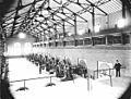
1895 Lower Dam - 7 of 8 - 35 Hz plus 2 - DC generators (Minnesota Historical Society)

