St. Hilaire, Minnesota facts for kids
Quick facts for kids
St. Hilaire
|
|
|---|---|

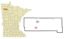
Location of St. Hilaire, Minnesota
|
|
| Country | United States |
| State | Minnesota |
| County | Pennington |
| Founded | Incorporated |
| 1882 | July 4, 1883 |
| Area | |
| • Total | 0.84 sq mi (2.18 km2) |
| • Land | 0.78 sq mi (2.03 km2) |
| • Water | 0.06 sq mi (0.16 km2) |
| Elevation | 1,089 ft (332 m) |
| Population
(2020)
|
|
| • Total | 273 |
| • Estimate
(2021)
|
266 |
| • Density | 349.10/sq mi (134.77/km2) |
| Time zone | UTC-6 (CST) |
| • Summer (DST) | UTC-5 (CDT) |
| ZIP code |
56754
|
| Area code(s) | 218 |
| FIPS code | 27-57022 |
| GNIS feature ID | 0650607 |
St. Hilaire is a small city in Pennington County, Minnesota, United States. It is located in River Falls Township. In 2020, the city had a population of 273 people.
Contents
History of St. Hilaire
St. Hilaire was first planned out in 1882. It officially became a village on July 4, 1883. On that same day, the city also got its first train service. The Great Northern Railway opened a new train line. This line connected St. Hilaire to other towns like Crookston.
People have a few ideas about how St. Hilaire got its name:
- A Frenchman named St. Hilaire lived by the Red Lake River. He sold things like gunpowder and tobacco. When people needed supplies, they would "go to St. Hilaire." The name then stuck for the area.
- Another idea is that a Frenchman named Arthur Yvernault bought the land where the town was built. He named the town after his hometown in France.
- The third idea is that it was named by Hon. Frank Ives. He was a judge from Crookston, Minnesota. He named it after a French politician and writer named Jules Barthélemy-Saint-Hilaire. This idea is supported by a historian named Warren Upham and the Minnesota Historical Society.
Harry Ives, Frank Ives's son, was the first postmaster in St. Hilaire in 1882. He also started the first newspaper for the community, called the St. Hilaire Spectator. This newspaper was published from 1883 until 1942.
Geography of St. Hilaire
St. Hilaire is located in Minnesota. According to the United States Census Bureau, the city covers a total area of about 0.83 square miles (2.18 square kilometers). Most of this area, about 0.77 square miles (2.03 square kilometers), is land. The rest, about 0.06 square miles (0.16 square kilometers), is water.
People of St. Hilaire
| Historical population | |||
|---|---|---|---|
| Census | Pop. | %± | |
| 1890 | 193 | — | |
| 1900 | 840 | 335.2% | |
| 1910 | 468 | −44.3% | |
| 1920 | 346 | −26.1% | |
| 1930 | 280 | −19.1% | |
| 1940 | 288 | 2.9% | |
| 1950 | 276 | −4.2% | |
| 1960 | 270 | −2.2% | |
| 1970 | 337 | 24.8% | |
| 1980 | 388 | 15.1% | |
| 1990 | 298 | −23.2% | |
| 2000 | 272 | −8.7% | |
| 2010 | 279 | 2.6% | |
| 2020 | 273 | −2.2% | |
| 2021 (est.) | 266 | −4.7% | |
| U.S. Decennial Census 2020 Census |
|||
2010 Census Information
In 2010, there were 279 people living in St. Hilaire. These people lived in 123 households. About 71 of these households were families.
Most of the people in St. Hilaire were White (97.8%). A small number were Native American (1.1%) or from other races. About 1.4% of the population was Hispanic or Latino.
About 30.9% of households had children under 18 living with them. Many households (43.1%) were married couples. Some households (32.5%) were made up of people living alone. About 8.2% of households had someone aged 65 or older living by themselves.
The average age of people in the city was 37.1 years old. About 25.1% of residents were under 18. Also, 11.5% of residents were 65 years or older. The city had slightly more males (53.0%) than females (47.0%).
See also
 In Spanish: St. Hilaire (Minnesota) para niños
 | Emma Amos |
 | Edward Mitchell Bannister |
 | Larry D. Alexander |
 | Ernie Barnes |

