Stanardsville, Virginia facts for kids
Quick facts for kids
Stanardsville
|
||
|---|---|---|

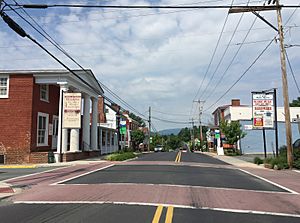
Central Stanardsville
|
||
|
||
 Location of Stanardsville within the Greene County
|
||
| Country | ||
| State | ||
| County | Greene | |
| Area | ||
| • Total | 0.36 sq mi (0.93 km2) | |
| • Land | 0.36 sq mi (0.93 km2) | |
| • Water | 0.00 sq mi (0.00 km2) | |
| Elevation | 663 ft (202 m) | |
| Population
(2020)
|
||
| • Total | 349 | |
| • Estimate
(2019)
|
386 | |
| • Density | 1,081.23/sq mi (417.11/km2) | |
| Time zone | UTC−5 (Eastern (EST)) | |
| • Summer (DST) | UTC−4 (EDT) | |
| ZIP code |
22973
|
|
| Area code(s) | 434 | |
| FIPS code | 51-75008 | |
| GNIS feature ID | 1500151 | |
Stanardsville is a small town in Greene County, Virginia, United States. It is known as the county seat of Greene County. This means it is where the main government offices for the county are located.
In 2020, about 349 people lived in Stanardsville. The town is named after Robert Stanard. He was a kind person who gave land for the town to use. Stanardsville is also part of the larger Charlottesville, Virginia metropolitan area.
Contents
History of Stanardsville
Stanardsville got its name from the Stanard family. They owned a lot of land in the area. In 1794, they helped plan the first parts of the town.
Later, in 1838, Greene County was formed. This new county was made from land that used to be part of Orange County. Stanardsville was chosen to be the main town, or county seat, for Greene County.
Several important buildings and areas in Stanardsville are listed on the National Register of Historic Places. This list helps protect places that are important to history. Some of these places include the Greene County Courthouse, the Beadles House, the Octonia Stone, the Powell–McMullan House, and the Stanardsville Historic District.
Geography of Stanardsville
Stanardsville is located in the middle of Greene County. It sits at the eastern base of the Blue Ridge Mountains. The town's exact location is 38°17′49″N 78°26′22″W / 38.29694°N 78.43944°W.
The United States Census Bureau says that Stanardsville covers a total area of about 0.9 square kilometers (0.36 square miles). All of this area is land.
Transportation in Stanardsville
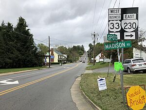
The main roads that go through Stanardsville are U.S. Route 33 Business and Virginia State Route 230. U.S. Route 33 Business is the older path of U.S. Route 33. The newer U.S. Route 33 now goes around the town to the south.
U.S. Route 33 goes east towards Richmond. It goes west towards Skyline Drive and then to Harrisonburg. Virginia State Route 230 heads northeast. It connects Stanardsville to Madison and further to Washington, D.C. by way of U.S. Route 29.
Population of Stanardsville
| Historical population | |||
|---|---|---|---|
| Census | Pop. | %± | |
| 1930 | 229 | — | |
| 1940 | 212 | −7.4% | |
| 1950 | 182 | −14.2% | |
| 1960 | 283 | 55.5% | |
| 1970 | 296 | 4.6% | |
| 1980 | 284 | −4.1% | |
| 1990 | 257 | −9.5% | |
| 2000 | 476 | 85.2% | |
| 2010 | 367 | −22.9% | |
| 2020 | 349 | −4.9% | |
| U.S. Decennial Census | |||
Every ten years, the United States counts its population in a process called a census. The 2020 census showed that 349 people lived in Stanardsville. This was a small decrease from the 367 people counted in 2010.
In 2000, there were 476 people living in the town. These people lived in 183 households. A household means all the people living together in one home. About 116 of these households were families.
The population was made up of different groups. Most people were White (88.87%). There were also African American (8.61%) and Native American (0.21%) residents. Some people were from other races (1.05%) or from two or more races (1.26%). A small number (0.84%) were of Hispanic or Latino background.
About 31.1% of households had children under 18 living with them. The average household had about 2.21 people. The average family had about 2.73 people.
The town's population had people of all ages. About 23.3% were under 18 years old. About 29.4% were 65 years or older. The average age in the town was 41 years old.
See also
 In Spanish: Stanardsville (Virginia) para niños
 | Percy Lavon Julian |
 | Katherine Johnson |
 | George Washington Carver |
 | Annie Easley |


