
Stanley Peak (Ball Range) facts for kids
Quick facts for kids Stanley Peak |
|
|---|---|

Stanley Peak from Mt. Whymper, 2004
|
|
| Highest point | |
| Elevation | 3,155 m (10,351 ft) |
| Prominence | 248 m (814 ft) |
| Geography | |
| Location | Kootenay National Park |
| Parent range | Ball Range Canadian Rocky Mountains |
| Climbing | |
| First ascent | 1901 by Edward Whymper and guides |
| Easiest route | Difficult scramble; UIAA III |
Stanley Peak is a tall mountain found in the Canadian Rocky Mountains. It stands 3,155 meters (about 10,335 feet) high. This impressive peak is located in the beautiful Kootenay National Park in British Columbia, Canada. It's part of a group of mountains called the Ball Range.
Contents
About Stanley Peak
Stanley Peak is a well-known landmark in the Canadian Rockies. Its height makes it one of the taller peaks in the area. The mountain is a popular spot for adventurers and nature lovers.
How Stanley Peak Got Its Name
The mountain was named in 1901 by the first person to climb it, an English explorer named Edward Whymper. He named it after Frederick Stanley, 16th Earl of Derby, who was the sixth Governor-General of Canada. A Governor-General is like a representative of the King or Queen in a country.
Some records also suggest the name might have been given in 1912. This later naming was possibly after Stanley H. Mitchell, who was a secretary for the Alpine Club of Canada.
Seeing and Exploring Stanley Peak
You can easily see Stanley Peak from the Trans-Canada Highway and Highway 93. These are major roads that run through the area.
On the northeast side of the peak, there is a large ice formation called Stanley Glacier. You can get a closer look at this glacier by following a hiking trail. This trail leads into a special valley located between Stanley Peak and another mountain called Storm Mountain.
Climbing Stanley Peak can be quite challenging. There is a route that involves scrambling, which means using your hands and feet to climb over rocks. This route is best attempted in late summer when the snow has melted. It requires good navigation skills to find the way through the many rock ledges and gullies on the mountain's north face.
Images for kids
-
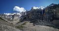
The valley below Stanley Peak and its glacier, taken from the Stanley Glacier Trail

