Stanwell-Fletcher Lake facts for kids
Quick facts for kids Stanwell-Fletcher Lake |
|
|---|---|
| Location | Somerset Island, Nunavut, Canada |
| Coordinates | 72°46′N 94°48′W / 72.767°N 94.800°W |
| Type | Lake |
| Etymology | Named after USAAF Major J.F. Stanwell-Fletcher |
| Primary inflows | Stanwell-Fletcher River |
| Primary outflows | Union River |
| Catchment area | 1,970 square kilometres (760 sq mi) |
| Basin countries | Canada |
| Surface area | 339 km2 (131 sq mi) |
| Max. depth | About 100 m (330 ft) |
| Surface elevation | 7.6 m (25 ft) |
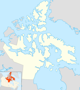
Stanwell-Fletcher Lake is the biggest lake on Somerset Island. This island is the tenth-largest in the Canadian Arctic Archipelago. The lake and most of Somerset Island are found in the Qikiqtaaluk Region of Nunavut, a territory in Canada.
Where is Stanwell-Fletcher Lake?
Stanwell-Fletcher Lake is in the middle of Somerset Island. It is west of Creswell Bay and east of Four Rivers Bay. Creswell Bay is a large inlet on the island's eastern coast. Four Rivers Bay is part of Peel Sound. The lake has a few small islands that do not have names.
How does water flow in and out of the lake?
Many smaller streams flow into Stanwell-Fletcher Lake. The biggest one is the Stanwell-Fletcher River. This river starts at Fiona Lake and flows into the north end of Stanwell-Fletcher Lake.
The water leaves the lake through the Union River. This river flows from the eastern side of the lake into Creswell Bay. The Union River is about 4 km (2.5 mi) long. The area of land that drains water into the lake is about 1,970 km2 (760 sq mi). This is about 8% of all of Somerset Island. The lake itself covers an area of 339 km2 (131 sq mi).
How does the climate affect the lake?
Somerset Island has a tundra climate. This means it is very cold. The lake, rivers, and streams around it are frozen for most of the year. This stops a lot of water from flowing in or out.
In the 1960s, the lake's ice cover stayed frozen for several years. It hardly thawed in the summer. But a study in 2015 showed that the ice is now melting more each year. The most melting happens in July and August.
Is the lake fresh or salt water?
Stanwell-Fletcher Lake is a fresh water lake. This means its water is not salty. The water in the lake mixes completely once a year. It stays at a steady average temperature of about 1.5 °C (34.7 °F).
Long ago, around 2400 years ago, the lake basin was connected to the sea. It was a salty fjord. Over time, the salt water was slowly replaced by fresh water. This happened as the lake became separated from the sea.
How was the lake formed?
Stanwell-Fletcher Lake was formed by glaciers. During the Pleistocene Ice Age, a huge sheet of ice called the Innuitian Ice Sheet moved across the land. This ice carved out the basin where the lake now sits. This process is called glacial scouring.
After the glacier melted, the basin might have been part of a fjord. This fjord would have been connected to Creswell Bay or Four Rivers Bay. It might even have been a strait that split Somerset Island in half.
What happened after the ice melted?
After the ice melted, the land slowly rose up. This process is called Post-glacial rebound. By about 3500 years ago, this rising land had separated the lake from the sea. However, some salty water from the sea still flowed in during certain seasons or tides until about 2400 years ago.
What kind of rocks are around the lake?
Most of the rocks around the lake are very old, from the Precambrian time. The rocks to the northwest and under the lake are likely from the Cretaceous and Tertiary periods.
The land rises steeply to the west, southwest, and northeast of the lake. In the southeast, the land is lower and leads to Creswell Bay. The land around the Stanwell-Fletcher River in the northwest slopes more gently.
What is the bottom of the lake like?
The bottom of Stanwell-Fletcher Lake is mostly mud. This mud comes from old, decayed plants. There are also small pebbles. In the northeast, there are finer sediments. This is because several rivers from the nearby highlands have built up large deltas there.
The deepest part of the lake is a U-shaped valley. This valley runs from the northwest to the southeast. It reaches a depth of about 100 m (330 ft). The lake bottom drops sharply into this deep valley in the northwest. There are shallower areas, like shelves, in the southwest and northeast.
History of the Lake Area
People have lived on Somerset Island for a very long time. Inuit or pre-Inuit cultures lived here throughout history.
Who lived near the lake?
Scientists have found signs of old settlements on the northwest shore of the lake. These settlements belonged to the Pre-Dorset and Dorset people. They were found along steep valleys that lead to the west coast of the island. These valleys might have been part of a fjord connected to the lake in the past.
How did the lake get its name?
European explorers mapped the coast of Somerset Island in the 1800s. But they did not explore the inland areas much. Stanwell-Fletcher Lake was named sometime between 1943 and 1965.
It was named after Major J.F. Stanwell-Fletcher. He was a pilot in the USAAF. In 1943, he parachuted into Fort Ross. This was the first time someone parachuted north of the Arctic Circle. He made the jump to help with moving people from a trading post in the southeast of Somerset Island.
 | Janet Taylor Pickett |
 | Synthia Saint James |
 | Howardena Pindell |
 | Faith Ringgold |


