Staunton River State Park facts for kids
Staunton River State Park is a fun state park in Virginia. It was one of the first state parks in Virginia. The park was built by the Civilian Conservation Corps and opened in 1936. You can find it along the Staunton River near Scottsburg, Virginia. It's also a special place called an International Dark Sky Park, which means it's great for looking at stars!
Contents
Where is Staunton River State Park?
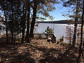
The park's construction started in 1933. It is located where the Staunton River and the Dan River meet. Later, in the early 1950s, a large lake called Buggs Island Lake was formed nearby. These two rivers are part of the Roanoke River basin. The area from the park downstream along the Roanoke River is known as the Roanoke River valley.
Why is it Called Staunton River?
The park gets its name from the Staunton River, which runs along its edge. Today, this river is also known as the Roanoke River. But many local people still call it the Staunton River (pronounced "Stanton").
The river is believed to be named after Captain Henry Staunton. Before the American Revolutionary War, Captain Staunton led a group of soldiers. Their job was to patrol the river valley. They protected settlers in Virginia from attacks. Because of his work, this part of the river became known as "Captain Staunton's River." Later, it was simply called the Staunton River.
History of Staunton River State Park
|
Staunton River State Park Historic District
|
|

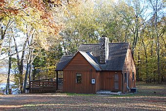
A cabin in the park
|
|
| Lua error in Module:Location_map at line 420: attempt to index field 'wikibase' (a nil value). | |
| Nearest city | Scottsburg, Virginia |
|---|---|
| Area | 1,597 acres (646 ha) |
| Built | 1933 |
| Architectural style | Late 19th And Early 20th Century American Movements, Modern Movement |
| NRHP reference No. | 07000402 |
| Significant dates | |
| Added to NRHP | May 4, 2007 |
The first European settlers in this area were small farmers. Over time, growing tobacco became very popular. This led to the growth of large farms called plantations. Many of these plantations were located along the Staunton River.
Two famous plantations were Red Hill and Roanoke Plantation. Red Hill was the last home of Patrick Henry, a famous American. Roanoke Plantation was where Captain Adam Clement lived. His son, John Marshall Clemens, was the father of Samuel Clemens, also known as Mark Twain.
The Fork Plantation was located right where Staunton River State Park is today. In 1839, Richard Logan took ownership of this large plantation. It covered more than 1,000 acres (4.0 km2) of land. There was also a Fork Mission church nearby.
River Travel and Trade
Plantations needed ways to transport their crops. The Staunton and Dan Rivers were perfect for this. People used special flat-bottomed boats called bateaux (pronounced "bah-TOH"). These boats traveled upstream from Brookneal and downstream to Clarksville and Gaston, North Carolina.
Samuel Pannilla owned many of these boats. His boats would stop at his plantation and other landings. They picked up and delivered goods for different shippers. This river transportation system was important until the Civil War. It became popular again in 1869. However, when railroads arrived, most river travel stopped.
Matt Haskins was a very strong African American man. He was known as a legend among the bateau men. People said he could lift a 200-pound (91 kg) sack of fertilizer with his teeth! He could also pick up a barrel of liquor and drink from it.
Life on the Plantations
After the Civil War, the Fork Plantation fell apart. Tenant farmers then took over the land. The land near the rivers was very rich and good for farming. Farmers could harvest 500–600 pounds (230–270 kg) of corn each year. Tobacco was the main crop, and a lot of it was grown. One landlord might have had about 50 tenant farmers and their families living on what is now the park land.
A Unique Community Experiment
In 1899, a group from Wisconsin tried something new. They started a Christian social colony at the fork of the rivers. It was an experimental community, like a Utopia. On August 8, 1899, J. C. Zimmerman bought 1,426 acres (5.77 km2) of land. He led about nine or ten families to start the colony.
Their buildings were set up in a half-circle shape. A shared kitchen and dining room were in the middle. But the people didn't know much about farming in this area. The colony started to fail, and the group soon left.
Building the State Park
In 1933, the state of Virginia bought 1,196 acres (4.84 km2) of land. This land came from J. W. Johnson and his family. More land was bought for the park too. From 1933 to 1935, a group called the Civilian Conservation Corps (CCC) worked at "the fork." They built most of the park's buildings and facilities.
In 1936, Staunton River State Park officially opened. It was one of the first six state parks in Virginia. The park covered 1,776 acres (7.19 km2). It offered many fun activities for people in south-central Virginia.
In 1952, the John H. Kerr Dam was finished. This created Buggs Island Lake, and part of the park was flooded. Today, the park still offers lots of recreation. You can find a pool, tennis courts, a volleyball court, and picnic areas. There's also a children's playground, a place to launch boats, a campground, and cabins. You can also explore nature trails. The park is in a quiet, rural area, and much of its original beauty remains.
Historic Buildings in the Park
The Staunton River State Park Historic District was added to the National Register of Historic Places in 2007. This means the area is important for its history. The historic district includes 14 buildings, 5 sites, and 5 structures that are important to its history.
These include the District Manager's House and garage (built in 1934). There's also the restaurant and visitor's center (1935-1936). The pool area, with its bath house and concession building, is also historic. Picnic areas, including shelters and restrooms, were built between 1933 and 1935. The cabins (1934-1936), campground (1940), and tennis courts (1937) are also part of this historic district.
 | Sharif Bey |
 | Hale Woodruff |
 | Richmond Barthé |
 | Purvis Young |


