
Steeles Avenue facts for kids
Quick facts for kids
|
|||||||
|---|---|---|---|---|---|---|---|
| Lua error in Module:Infobox_road/map at line 15: attempt to index field 'wikibase' (a nil value). | |||||||
| Major junctions | |||||||
| West end | Milborough Townline | ||||||
| East end | Scarbough Pickering Townline | ||||||
| Location | |||||||
| Major cities: | Toronto | ||||||
| Highway system | |||||||
Roads in Ontario
|
|||||||


Steeles Avenue is a major street in Ontario, Canada. It runs from west to east. This road forms the northern edge of Toronto. It also forms the southern edge of York Region.
Steeles Avenue is about 38.75 kilometers long within Toronto. It stretches between Albion Road and the border of Scarborough and Pickering. West of Albion Road, Steeles Avenue continues into Peel Region. Here, it is also known as Peel Regional Road 15. It goes through Brampton and into Halton Region in Milton. The road stops at Appleby Line because of the Crawford Lake Conservation Area. It then starts again east of Guelph Line. It continues until the Milborough Townline, which is on the border of Milton and Hamilton. East of the Toronto-Pickering border, Steeles Avenue changes its name to Taunton Road.
Contents
How Steeles Avenue Got Its Name
Steeles Avenue is named after a person called J. C. Steele. He owned a tavern, which is like an old-fashioned inn or pub. This tavern was located on the street where it meets Yonge Street.
Once Called Ontario's Worst Road
In October 2006, the CAA said Steeles Avenue was the worst road in Ontario. A year later, in October 2007, it was listed as the fifth worst. Then, in October 2008, it was again named the worst road in Ontario.
The main reasons for this were many potholes and the poor quality of the road. After the CAA's report, some parts of the road were fixed. These repairs happened between Dufferin Street and Bayview Avenue.
Cool Places Along Steeles Avenue
Many interesting places are located along Steeles Avenue. Here are some of them, listed from west to east:
| Landmark | Cross street | Notes | Image |
|---|---|---|---|
| Crawford Lake Conservation Area | Guelph Line | A beautiful nature area with a rare meromictic lake. |  |
| Toronto Premium Outlets | Trafalgar Road | The first Premium Outlets shopping center in Canada. | |
| Sheridan College-Davis Campus | McLaughlin Road | Sheridan’s biggest campus, with nearly 8,000 students. |  |
| Shoppers World Brampton | Hurontario Street | A large shopping mall in Brampton. |  |
| Wet 'n' Wild Toronto | Finch Avenue West | One of Canada's largest waterparks, great for summer fun! | |
| Black Creek Pioneer Village | Jane Street | A living history museum showing what life was like in the 1800s. |  |
| Pioneer Village station | Northwest Gate | A subway station on the Toronto subway system. |  |
| York University | Keele Street, Founders Road, Murray Ross Parkway | Toronto's second largest university. | .jpg) |
| Centerpoint Mall | Yonge Street | A shopping mall located at a busy intersection. |  |
| Pacific Mall | Kennedy Road | The largest indoor Chinese Asian mall in North America. |  |
| Splendid China Mall | Kennedy Road, Redlea Avenue | Another large Asian shopping mall. |  |
| Milliken GO Station | Old Kennedy Road, Silverstar Boulevard | A GO Transit train station for commuters. |  |
Images for kids
-
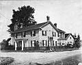
The Green Bush Inn at Yonge and Steeles; circa 1920
-

Steeles Ave. in Brampton
-
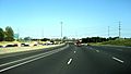
Highway 404 southbound approaching interchange with Steeles Avenue, circa 2007.


