Still Fork facts for kids
Quick facts for kids Still Fork |
|
|---|---|

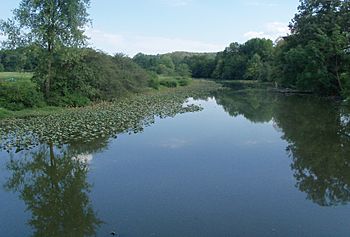
From Arrow Road Bridge
|
|
| Country | United States |
| State | Ohio |
| Region | Carroll County, Ohio |
| Physical characteristics | |
| Main source | Fox Township, Carroll County 1,180 ft (360 m) 40°37′10″N 80°56′08″W / 40.61944°N 80.93556°W |
| River mouth | Sandy Creek Minerva, Carroll County 1,027 ft (313 m) 40°42′59″N 81°06′31″W / 40.71639°N 81.10861°W |
| Length | 16.1 mi (25.9 km) |
| Basin features | |
| Basin size | 71.4 sq mi (185 km2) |
Still Fork is a small river, also called a creek, located in eastern Ohio in the United States. It flows for about 16.1 miles (25.9 km) and is a branch of the Sandy Creek. Still Fork is part of a much larger water system that eventually reaches the Mississippi River. This means that water from Still Fork travels through Sandy Creek, then the Tuscarawas, Muskingum, and Ohio Rivers before joining the mighty Mississippi.
The Still Fork river basin, which is the area of land where all the water drains into the river, covers about 71.4 square miles (185 km2) in Carroll County, Ohio. The river starts in eastern Carroll County at an elevation of about 1,180 feet (360 meters). It then flows northwest through several townships like Fox, Washington, Augusta, and Brown. Finally, it reaches its end, or mouth, in Minerva, Ohio, at an elevation of about 1,027 feet (313 meters).
Along its path, the Still Fork valley is home to the Ohi-Rail Corporation (OHIC) railway and Arbor Road. Near Augusta, the creek passes through a rural Amish community. Downstream from Ohio State Route 9, you'll find the small community of Pattersonville. Other small communities in the area include Mechanicstown and Norristown.
In the past, people wanted to use Still Fork for transportation. On February 15, 1837, the state of Ohio passed a law to create the Still Fork of Sandy Navigation Company. This company was formed by seven men from Carroll County.
What was the Company's Goal?
The company's main goal was to build and maintain a "navigable canal or slack-water navigation" system. This means they wanted to make the river easier for boats to travel on. They planned to start near William Croxton's land, where the road between New Lisbon and Carrollton crossed Still Fork. From there, they wanted to follow the river's path to connect with the Sandy and Beaver Canal in Pekin, Carroll County.
To help with this, the company was allowed to use nearby streams or ponds as "reservoirs or feeders." These would store water and feed it into the canal system to keep it at the right level for boats. The company raised $65,000 by selling shares, with each share costing $25.
Still Fork's Tributaries
Still Fork has several smaller streams, called tributaries, that flow into it. These tributaries add water to Still Fork as it makes its way to Sandy Creek. Here are some of the main ones:
- Muddy Fork: This is a significant tributary, about 8.3 miles (13.4 km) long. It flows into Still Fork and has its own drainage area of about 17.1 square miles (44.3 km2).
- Wholebark Run: This smaller stream is about 1.6 miles (2.6 km) long.
- Pumpkin Run: Another short tributary, Pumpkin Run is about 1.9 miles (3.1 km) long.
- Reeds Run: This stream flows for about 5 miles (8.0 km) before joining Still Fork.
- Pipes Fork: Pipes Fork is about 4.2 miles (6.8 km) long and contributes to Still Fork's flow.
- Friday Creek: This tributary is about 4.4 miles (7.1 km) long and also flows into Still Fork.
 | Ernest Everett Just |
 | Mary Jackson |
 | Emmett Chappelle |
 | Marie Maynard Daly |

