Stockville, Nebraska facts for kids
Quick facts for kids
Stockville, Nebraska
|
|
|---|---|
|
Village
|
|

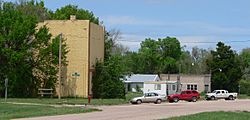
Downtown Stockville: west side of Wellington Street, May 2010
|
|

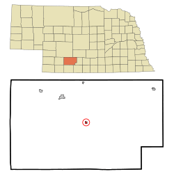
Location of Stockville, Nebraska
|
|
| Country | United States |
| State | Nebraska |
| County | Frontier |
| Area | |
| • Total | 0.26 sq mi (0.68 km2) |
| • Land | 0.26 sq mi (0.68 km2) |
| • Water | 0.00 sq mi (0.00 km2) |
| Elevation | 2,484 ft (757 m) |
| Population
(2020)
|
|
| • Total | 25 |
| • Density | 95.42/sq mi (36.81/km2) |
| Time zone | UTC-6 (Central (CST)) |
| • Summer (DST) | UTC-5 (CDT) |
| ZIP code |
69042
|
| Area code(s) | 308 |
| FIPS code | 31-47290 |
| GNIS feature ID | 2399906 |
Stockville is a small village in Frontier County, Nebraska, USA. In 2010, only 25 people lived there. It is the main town, or "county seat," for Frontier County. This means it is where the county government is located.
Contents
History of Stockville
How Stockville Got Its Start
Stockville was founded in 1872. Its name comes from the many livestock (farm animals like cattle) in the area. Many ranchers lived here.
Early Settlers and Native Americans
Before Stockville was founded, a group of Oglala Dakota people lived near the area. They were called the Cut-off Oglala. They settled there in 1870. Around the same time, white cattlemen also started to move into the area. They settled near Medicine Creek.
In 1872, an Oglala chief named Whistler and two other Oglala people were killed. This likely happened because of white bison hunters. After these events, the Oglala people left the valley. They moved to a special area called an Indian reservation between 1873 and 1874.
Geography of Stockville
Stockville is a small village. The United States Census Bureau says it covers about 0.26 square miles (0.68 square kilometers). All of this area is land, with no water.
Population Changes in Stockville
The number of people living in Stockville has changed a lot over the years. Here is a look at the population from 1890 to 2020:
| Historical population | |||
|---|---|---|---|
| Census | Pop. | %± | |
| 1890 | 227 | — | |
| 1900 | 269 | 18.5% | |
| 1910 | 232 | −13.8% | |
| 1920 | 196 | −15.5% | |
| 1930 | 186 | −5.1% | |
| 1940 | 238 | 28.0% | |
| 1950 | 181 | −23.9% | |
| 1960 | 91 | −49.7% | |
| 1970 | 61 | −33.0% | |
| 1980 | 45 | −26.2% | |
| 1990 | 32 | −28.9% | |
| 2000 | 36 | 12.5% | |
| 2010 | 25 | −30.6% | |
| 2020 | 25 | 0.0% | |
| U.S. Decennial Census | |||
Stockville's Population in 2010
In 2010, a census (a count of all people) showed that 25 people lived in Stockville. These people lived in 11 different homes, and 8 of these were families.
Population Density and Housing
The population density was about 96 people per square mile (37 people per square kilometer). This means there were not many people living close together. There were 19 housing units in the village. On average, there were about 73 housing units per square mile (28 per square kilometer).
Racial Background of Residents
Most people in Stockville were White, making up 96.0% of the population. A small part, 4.0%, were from other races. Also, 4.0% of the population were Hispanic or Latino.
Households and Families
Out of the 11 homes, 18.2% had children under 18 living there. Most homes (72.7%) were married couples living together. About 27.3% of homes were not families. This means they were individuals living alone. Also, 9.1% of homes had someone 65 years or older living by themselves. The average home had 2.27 people, and the average family had 2.75 people.
Age and Gender in Stockville
The average age of people in Stockville was 62.8 years. This shows it is an older community.
- 20% of residents were under 18 years old.
- No one was between 18 and 24 years old.
- 8% were between 25 and 44 years old.
- 32% were between 45 and 64 years old.
- 40% were 65 years of age or older.
When it came to gender, 48.0% of the population was male, and 52.0% was female.
Famous People from Stockville
- Frank B. Morrison was the 31st Governor of Nebraska. He was an important political leader for the state.
See also
 In Spanish: Stockville (Nebraska) para niños
 | Tommie Smith |
 | Simone Manuel |
 | Shani Davis |
 | Simone Biles |
 | Alice Coachman |

